Country:
 Romania
Region:
City:
Latitude and Longitude:
Time Zone:
Postal Code:
IP information under different IP Channel
ip-api
Country
Region
City
ASN
Time Zone
ISP
Blacklist
Proxy
Latitude
Longitude
Postal
Route
IPinfo
Country
Region
City
ASN
Time Zone
ISP
Blacklist
Proxy
Latitude
Longitude
Postal
Route
MaxMind
Country
Region
City
ASN
Time Zone
ISP
Blacklist
Proxy
Latitude
Longitude
Postal
Route
Luminati
Country
RORegion
if
City
bragadiru
ASN
Time Zone
Europe/Bucharest
ISP
Net Gate Comunicatii Srl
Latitude
Longitude
Postal
db-ip
Country
Region
City
ASN
Time Zone
ISP
Blacklist
Proxy
Latitude
Longitude
Postal
Route
ipdata
Country
Region
City
ASN
Time Zone
ISP
Blacklist
Proxy
Latitude
Longitude
Postal
Route
Popular places and events near this IP address

Berceni, Ilfov
Commune in Ilfov, Romania
Distance: Approx. 6380 meters
Latitude and longitude: 44.31666667,26.18333333
Berceni is a commune in the southeastern part of Ilfov County, Muntenia, Romania, composed of a single village, Berceni. The commune is located at the southern edge of Bucharest, about 15 km (9.3 mi) from the city center, to which it is connected by the Berceni Road and the DJ401 county road. On its northwestern side, the commune abuts the Berceni neighborhood of Bucharest, while on its southeastern side it abuts Giurgiu County.

1 Decembrie
Commune in Ilfov, Romania
Distance: Approx. 8121 meters
Latitude and longitude: 44.28333333,26.06666667
1 Decembrie is a commune in the south of Ilfov County, Muntenia, Romania, composed of a single village, 1 Decembrie. It also included the village of Copăceni until 2005, when it was split off to form a separate commune.

Vidra, Ilfov
Commune in Ilfov, Romania
Distance: Approx. 1256 meters
Latitude and longitude: 44.26666667,26.15
Vidra is a commune in the south of Ilfov County, Muntenia, Romania. Its name means "otter". It is composed of three villages: Crețești, Sintești, and Vidra.
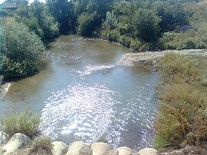
Neajlov
River in Giurgiu, Romania
Distance: Approx. 8893 meters
Latitude and longitude: 44.18722222,26.20611111
The Neajlov is a river in Romania. It is a right tributary of the river Argeș, which it meets near Gostinari, Giurgiu County. It rises from the higher Romanian Plain, east of Pitești.

Copăceni, Ilfov
Commune in Ilfov, Romania
Distance: Approx. 6851 meters
Latitude and longitude: 44.27222222,26.07916667
Copăceni is a commune in Ilfov County, Muntenia, Romania, established in 2005 when it was split off from 1 Decembrie. It is composed of a single village, Copăceni.
Jilava massacre
1940 massacre in Romania
Distance: Approx. 9366 meters
Latitude and longitude: 44.335,26.1075
The Jilava massacre took place during the night of November 26, 1940, at Jilava Prison, near Bucharest, Romania. Sixty-four political detainees were killed by the Iron Guard (Legion), with further high-profile assassinations in the immediate aftermath. It came about halfway through the fascist National Legionary State and led to the first open clash between the Guard and conducător Ion Antonescu, who ousted the Legion from power in January 1941.

Adunații-Copăceni
Commune in Giurgiu, Romania
Distance: Approx. 9149 meters
Latitude and longitude: 44.25,26.05
Adunații-Copăceni is a commune located in Giurgiu County, Muntenia, Romania. It is composed of four villages: Adunații-Copăceni, Dărăști-Vlașca, Mogoșești, and Varlaam. The commune is situated in the southern part of the Wallachian Plain, on the banks of the Argeș River, at an altitude of 79 m (259 ft).

Vărăști
Commune in Giurgiu, Romania
Distance: Approx. 6991 meters
Latitude and longitude: 44.25,26.25
Vărăști is a commune located in Giurgiu County, Muntenia, Romania. It is composed of two villages, Dobreni and Vărăști.

Colibași, Giurgiu
Commune in Giurgiu, Romania
Distance: Approx. 6980 meters
Latitude and longitude: 44.2,26.18333333
Colibași is a commune located in Giurgiu County, Muntenia, Romania. It is composed of two villages, Câmpurelu and Colibași. The commune is situated in the Wallachian Plain, on the left bank of the Argeș River.

Battle of the Argeș
1916 battle during World War I
Distance: Approx. 9085 meters
Latitude and longitude: 44.26666667,26.05
The Battle of the Argeș took place during the Romanian Campaign of World War I.on 1 December 1916. The battle was fought along the line of the Argeș River in Romania between Austro-German forces of the Central Powers and Romanian forces with the Russian imperial forces.

Stadionul Berceni
Football stadium in Berceni, Romania
Distance: Approx. 5528 meters
Latitude and longitude: 44.30861111,26.18388889
Berceni Stadium is a football stadium in Berceni, Ilfov County, Romania. The stadium holds 2,700 people. The home was the ground of second division side ACS Berceni until 2016, the Stadionul Berceni stage three group matches at the 2011 UEFA European Under-19 Football Championship.
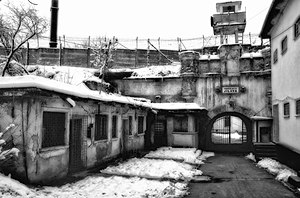
Jilava Prison
Prison in Jilava, Romania
Distance: Approx. 9366 meters
Latitude and longitude: 44.335,26.1075
Jilava Prison (Romanian: Penitenciarul București–Jilava) is a prison located in Jilava, a village south of Bucharest, Romania.
Weather in this IP's area
clear sky
12 Celsius
11 Celsius
11 Celsius
13 Celsius
1028 hPa
53 %
1028 hPa
1022 hPa
10000 meters
3.14 m/s
4.84 m/s
77 degree
3 %
07:35:20
18:24:52