Country:
 Croatia
Region:
City:
Latitude and Longitude:
Time Zone:
Postal Code:
IP information under different IP Channel
ip-api
Country
Region
City
ASN
Time Zone
ISP
Blacklist
Proxy
Latitude
Longitude
Postal
Route
IPinfo
Country
Region
City
ASN
Time Zone
ISP
Blacklist
Proxy
Latitude
Longitude
Postal
Route
MaxMind
Country
Region
City
ASN
Time Zone
ISP
Blacklist
Proxy
Latitude
Longitude
Postal
Route
Luminati
Country
HRRegion
17
City
split
ASN
Time Zone
Europe/Zagreb
ISP
Telemach Hrvatska d.o.o.
Latitude
Longitude
Postal
db-ip
Country
Region
City
ASN
Time Zone
ISP
Blacklist
Proxy
Latitude
Longitude
Postal
Route
ipdata
Country
Region
City
ASN
Time Zone
ISP
Blacklist
Proxy
Latitude
Longitude
Postal
Route
Popular places and events near this IP address
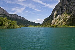
Cetina
River in Croatia
Distance: Approx. 654 meters
Latitude and longitude: 43.4398,16.6864
Cetina (pronounced [tsětina]) is a river in southern Croatia. It has a length of 101 km (63 mi) and its basin covers an area of 1,463 km2 (565 sq mi). From its source, Cetina descends from an elevation of 385 metres (1,263 ft) above sea level to the Adriatic Sea.

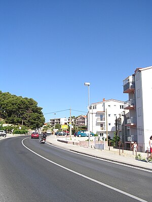
Omiš
Town in Split-Dalmatia, Croatia
Distance: Approx. 1352 meters
Latitude and longitude: 43.43333333,16.68333333
Omiš (Croatian pronunciation: [ɔ̌miːʃ], Latin and Italian: Almissa) is a town and port in the Dalmatia region of Croatia, and a municipality in the Split-Dalmatia County. The town is approximately 25 kilometres (16 miles) south-east of Croatia's second largest city, Split, where the Cetina River meets the Adriatic Sea. Omiš municipality has a population of 14,936 and its area is 266 square kilometres (103 sq mi).

Postira
Village and municipality in Split-Dalmatia County, Croatia
Distance: Approx. 8232 meters
Latitude and longitude: 43.38333333,16.63333333
Postira is a village and a municipality in Croatia in the Split-Dalmatia County on the island of Brač.
Duće
Village in Croatia
Distance: Approx. 2248 meters
Latitude and longitude: 43.45,16.66666667
Duće is a Croatian village situated close to Omiš in the Dugi Rat municipality, Split-Dalmatia County. It is a series of small settlements in Poljica, the area between the foot of the Mosor mountains and the Adriatic Sea. The village was founded prior to the 12th century.
Zakučac Hydroelectric Power Plant
Dam in Zakučac, Croatia
Distance: Approx. 1740 meters
Latitude and longitude: 43.4576,16.7016
Zakučac Hydroelectric Power Plant is a large power plant in Croatia that has four turbines with a nominal capacity of 122 megawatts (164,000 hp) each having a total capacity of 488 megawatts (654,000 hp). It is a high-pressure diversion plant located at the Cetina River mouth into the sea, near the city of Omiš. It is operated by Hrvatska elektroprivreda.

Mirabella Fortress (Peovica)
Distance: Approx. 192 meters
Latitude and longitude: 43.44483333,16.694
Mirabella Fortress (Peovica) is a fortress located above town of Omiš in Split-Dalmatia County, in Dalmatia, Croatia. Mirabella or Peovica is a Romanesque fortress, built in the 13th century above the town of Omiš by the Kačić family. Mirabella was a reliable hideout for the Omiš pirates who used to retreat into the safety of the Cetina gorge.

Starigrad Fortress
Distance: Approx. 595 meters
Latitude and longitude: 43.44472222,16.7
Starigrad Fortress is a 15th-century fortress located near Omiš in Split-Dalmatia county, in Dalmatia, Croatia. The fortress or Fortica was built during the Croatian–Ottoman wars as a primary defence against the Ottoman Empire. The precipitous fortification is sited on a 262 m (860 ft) ridge above the town Omiš.
Gata, Croatia
Village in Split-Dalmatia County, Croatia
Distance: Approx. 2664 meters
Latitude and longitude: 43.46666667,16.7
Gata is a village located at the foot of the mountain Mosor, 16 miles east of the city of Split, and 1.3 miles inland from the coast of the Adriatic Sea. It is administratively located within the city of Omiš, in the Split-Dalmatia County. The village had a population of 567 in the 2011 census.

Srijane Viaduct
Bridge in Central Croatia
Distance: Approx. 9017 meters
Latitude and longitude: 43.51728,16.738358
The Srijane Viaduct, also known as the Radovići Viaduct, is located between the Bisko and Blato na Cetini interchanges of the A1 motorway in Croatia. It is a 504 metres (1,654 ft) long plate girder reinforced concrete viaduct. At this location the motorway route follows a horizontal curve of 850 metres (2,790 ft) radius.
Brač Channel
Distance: Approx. 5601 meters
Latitude and longitude: 43.39515705,16.67277951
The Brač Channel (Croatian: Brački kanal) is a channel in the Adriatic Sea between the Dalmatian mainland and the island of Brač.

Jesenice, Croatia
Place in Split-Dalmatia, Croatia
Distance: Approx. 7947 meters
Latitude and longitude: 43.462,16.598
Jesenice is a settlement near Dugi Rat, Croatia, population 2,089 (census 2011). It consists of the villages of Bajnice, Krilo, Orij, and Suhi Potok.
Dubrava, Split-Dalmatia County
Village in Croatia
Distance: Approx. 7011 meters
Latitude and longitude: 43.497888,16.649609
Dubrava is a settlement in the Town of Omiš in Croatia. In 2021, its population was 305.
Weather in this IP's area
heavy intensity rain
17 Celsius
17 Celsius
17 Celsius
18 Celsius
1016 hPa
83 %
1016 hPa
1016 hPa
10000 meters
2.77 m/s
2.71 m/s
45 degree
93 %
06:38:28
18:54:47