Country:
 Croatia
Region:
City:
Latitude and Longitude:
Time Zone:
Postal Code:
IP information under different IP Channel
ip-api
Country
Region
City
ASN
Time Zone
ISP
Blacklist
Proxy
Latitude
Longitude
Postal
Route
IPinfo
Country
Region
City
ASN
Time Zone
ISP
Blacklist
Proxy
Latitude
Longitude
Postal
Route
MaxMind
Country
Region
City
ASN
Time Zone
ISP
Blacklist
Proxy
Latitude
Longitude
Postal
Route
Luminati
Country
HRRegion
17
City
split
ASN
Time Zone
Europe/Zagreb
ISP
Telemach Hrvatska d.o.o.
Latitude
Longitude
Postal
db-ip
Country
Region
City
ASN
Time Zone
ISP
Blacklist
Proxy
Latitude
Longitude
Postal
Route
ipdata
Country
Region
City
ASN
Time Zone
ISP
Blacklist
Proxy
Latitude
Longitude
Postal
Route
Popular places and events near this IP address

Salona
Roman ruined city in Croatia
Distance: Approx. 1020 meters
Latitude and longitude: 43.53944444,16.48305556
Salona (Ancient Greek: Σάλωνα) was an ancient city and the capital of the Roman province of Dalmatia. It was the last residence of the final western Roman Emperor Julius Nepos and acted as the de facto capital of the Western Roman Empire during the years 476-480. Salona is located in the modern town of Solin, next to Split, in Croatia.

Klis
Municipality in Dalmatian Hinterland, Croatia
Distance: Approx. 3455 meters
Latitude and longitude: 43.56666667,16.51666667
Klis (Croatian: Klis, Italian: Clissa, Turkish: Kilis) is a Croatian village and a municipality located around a mountain fortress bearing the same name.

Jadro
River in Croatia
Distance: Approx. 1704 meters
Latitude and longitude: 43.5347,16.4757
The Jadro is a watercourse in Dalmatia, Croatia, that discharges into the Adriatic Sea. The upper reaches of the Jadro River, as well as its source, Jadro Spring, are protected as an ichthyological nature reserve, partly due to the presence of an endemic species of soft-mouthed trout. The headwaters of the Jadro River were the original water supply for the ancient city comprised by Diocletian's Palace (now an area within the present day city of Split).
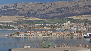
Vranjic
Village in Split-Dalmatia County, Croatia
Distance: Approx. 2127 meters
Latitude and longitude: 43.53063343,16.47242195
Vranjic (Italian: Vragnizza) is a village north of Split, near the mouth of Jadro River, administratively located in the Town of Solin. Because of its beauty it was nicknamed "Little Venice". The church of Saint Martin, the pope, is a place of cultural heritage, with sacred folk music performers Crkveni pjevači župe sv.
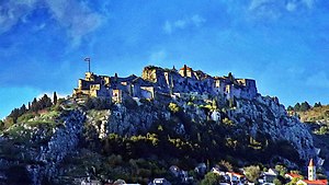
Fortress of Klis
Medieval fortress in Klis, Croatia
Distance: Approx. 3214 meters
Latitude and longitude: 43.56,16.52388889
The Klis Fortress (Croatian: Tvrđava Klis; Italian: Fortezza di Clissa) is a medieval fortress situated above the village of Klis, near Split, Croatia. From its origin as a small stronghold built by the ancient Illyrian tribe Dalmatae, to a role as royal castle and seat of many Croatian kings, to its final development as a large fortress during the Ottoman wars in Europe, Klis Fortress has guarded the frontier, being lost and re-conquered several times throughout its two-thousand-year-long history. Due to its location on a pass that separates the mountains Mosor and Kozjak, the fortress served as a major source of defense in Dalmatia, especially against the Ottoman Empire.

Aqueduct of Diocletian
Bridge in Dalmatia, Croatia
Distance: Approx. 1791 meters
Latitude and longitude: 43.52416667,16.48944444
The Aqueduct of Diocletian (Croatian: Dioklecijanov akvadukt) is an ancient Roman aqueduct near Split, Croatia (Latin: Spalatum) constructed during the Roman Empire to supply water to the palace of the emperor Diocletian, who was Augustus 284 to 305 AD, retired to Spalatum, and died there in 311.

Hollow Church
Church in Solin, Croatia
Distance: Approx. 131 meters
Latitude and longitude: 43.5403,16.497
Hollow Church (Croatian: Šuplja crkva) is the archaeological excavation of what used to be a Romanesque Roman Catholic church in the 11th-century Salona, Croatia.

Siege of Klis
1536–37 Ottoman victory in Croatia
Distance: Approx. 3214 meters
Latitude and longitude: 43.56,16.52388889
The siege of Klis or Battle of Klis (Croatian: Opsada Klisa, Bitka kod Klisa, Turkish: Klise Kuşatması) was a siege of Klis Fortress in the Kingdom of Croatia within Habsburg monarchy. The siege of the fortress, which lasted for more than two decades, and the final battle near Klis in 1537, were fought as a part of the Ottoman–Habsburg wars between the defending Croatian–Habsburg forces under the leadership of Croatian feudal lord Petar Kružić, and the attacking Ottoman army under the leadership of the Ottoman general Murat-beg Tardić. After the decisive Ottoman victory at the Battle of Krbava Field in 1493, and especially after the Battle of Mohács in 1526, the Croats continued defending themselves against the Ottoman attacks.

Dalmatia Tower
Mixed-use: office, hotel in Split, Croatia
Distance: Approx. 4193 meters
Latitude and longitude: 43.52027778,16.45111111
Dalmatia Tower is a high-rise office building and a hotel in Split, Croatia. It is located on the intersection of the Domovinskog rata Street and the Dubrovačka Street and it is the tallest building in Croatia.

University of Split Library
Distance: Approx. 3895 meters
Latitude and longitude: 43.511,16.4679
The University of Split Library is a scientific institution and the central library of the University of Split, which acquires and distributes information sources for the needs of all Split studies, providing users with appropriate conditions for learning and study work. After the National and University Libraries in Zagreb, it is the richest library in the Republic of Croatia. Its fund today has around 400,000 books and 12,000 serial publications, and its special collections contain a rich collection of rare and valuable books, geographical maps and atlases, pictorial materials and musicals.

Kučine, Croatia
Place
Distance: Approx. 2857 meters
Latitude and longitude: 43.5325,16.52972222
Kučine is a village near Solin, Croatia. In the 2011 census, it had 974 inhabitants.

Rižinice monastery
Historic site in Klis, Croatia
Distance: Approx. 1721 meters
Latitude and longitude: 43.5549,16.4988
Rupotine is an archeological site near Solin, Croatia, which is believed by Croatian archaeologists to be the site of medieval Rižinice monastery. It is considered one of the most significant early medieval Croatian archeological sites due to the inscription of duke Trpimir "PRO DUCE TREPIME(ro)" which was found here.
Weather in this IP's area
moderate rain
18 Celsius
18 Celsius
17 Celsius
18 Celsius
1016 hPa
77 %
1016 hPa
1014 hPa
10000 meters
4.63 m/s
110 degree
20 %
06:39:14
18:55:35