Country:
Region:
City:
Latitude and Longitude:
Time Zone:
Postal Code:
IP information under different IP Channel
ip-api
Country
Region
City
ASN
Time Zone
ISP
Blacklist
Proxy
Latitude
Longitude
Postal
Route
Luminati
Country
ASN
Time Zone
Europe/Zagreb
ISP
IPT d.o.o.
Latitude
Longitude
Postal
IPinfo
Country
Region
City
ASN
Time Zone
ISP
Blacklist
Proxy
Latitude
Longitude
Postal
Route
db-ip
Country
Region
City
ASN
Time Zone
ISP
Blacklist
Proxy
Latitude
Longitude
Postal
Route
ipdata
Country
Region
City
ASN
Time Zone
ISP
Blacklist
Proxy
Latitude
Longitude
Postal
Route
Popular places and events near this IP address

State of Slovenes, Croats and Serbs
1918 unrecognised pan-Slavic state in Southeast Europe
Distance: Approx. 582 meters
Latitude and longitude: 45.8,15.96666667
The State of Slovenes, Croats and Serbs (Serbo-Croatian: Država Slovenaca, Hrvata i Srba / Држава Словенаца, Хрвата и Срба; Slovene: Država Slovencev, Hrvatov in Srbov) was a political entity that was constituted in October 1918, at the end of World War I, by Slovenes, Croats and Serbs (Prečani) residing in what were the southernmost parts of the Austro-Hungarian Empire. Although internationally unrecognised, this was the first incarnation of a Yugoslav state founded on the Pan-Slavic ideology. Thirty-three days after it was proclaimed, the state joined the Kingdom of Serbia to form the Kingdom of Serbs, Croats and Slovenes.

Croatian Radiotelevision
Croatian radio television company
Distance: Approx. 653 meters
Latitude and longitude: 45.79305556,15.97472222
Hrvatska radiotelevizija (abbr. HRT), or Croatian Radiotelevision, is a Croatian public broadcasting company. It operates several radio and television channels, over a domestic transmitter network as well as satellite.

Trnje, Zagreb
Place
Distance: Approx. 609 meters
Latitude and longitude: 45.79480278,15.97920556
Trnje (Croatian pronunciation: [tr̩̂ːɲe]) is a district in the City of Zagreb, Croatia. According to the 2011 census, the district had 42,282 residents. It is located in the central part of the city, south of Donji grad across the railway (Zagreb Main Station), east of Trešnjevka (Savska road), west of Peščenica (Vjekoslav Heinzel Avenue and Marin Držić Avenue), and north of the river Sava.

Kingdom of Croatia-Slavonia
Territory within Austria-Hungary
Distance: Approx. 582 meters
Latitude and longitude: 45.8,15.96666667
The Kingdom of Croatia-Slavonia (Croatian: Kraljevina Hrvatska i Slavonija; Hungarian: Horvát-Szlavónország or Horvát–Szlavón Királyság; German: Königreich Kroatien und Slawonien) was a nominally autonomous kingdom and constitutionally defined separate political nation within the Austro-Hungarian Empire. It was created in 1868 by merging the kingdoms of Croatia and Slavonia following the Croatian–Hungarian Settlement of 1868. It was associated with the Kingdom of Hungary within the dual Austro-Hungarian state, being within the Lands of the Crown of St.
Eurotower (Zagreb)
Building in Zagreb, Croatia
Distance: Approx. 353 meters
Latitude and longitude: 45.79881,15.96945
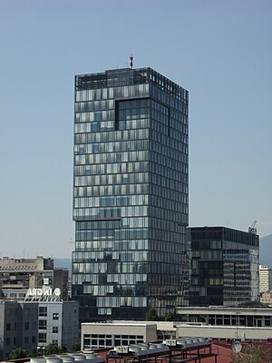
Eurotower is a high-rise building in Zagreb, Croatia, located in Trnje at the intersection of the Vukovarska and Lučićeva streets, in the southwest corner. It was built in 2006. This office tower has 26 levels and it is 96 m (315 ft) tall.
Faculty of Electrical Engineering and Computing, University of Zagreb
Technical faculty of the University of Zagreb
Distance: Approx. 308 meters
Latitude and longitude: 45.80091667,15.97127778
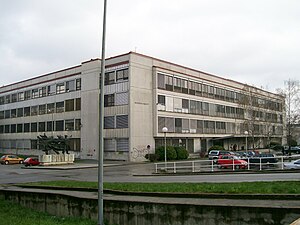
The Faculty of Electrical Engineering and Computing (Croatian: Fakultet elektrotehnike i računarstva, abbr: FER) is a faculty of the University of Zagreb. It is the largest technical faculty and the leading educational facility for research and development in the fields of electrical engineering and computing in Croatia. FER owns four buildings situated in the Zagreb neighbourhood of Martinovka, Trnje.

National and University Library in Zagreb
National library of Croatia and central library of the University of Zagreb
Distance: Approx. 368 meters
Latitude and longitude: 45.79666667,15.9775
National and University Library in Zagreb (NSK) (Croatian: Nacionalna i sveučilišna knjižnica u Zagrebu, NSK; formerly Nacionalna i sveučilišna biblioteka u Zagrebu, NSB) is the national library of Croatia and central library of the University of Zagreb. The Library was established in 1607. Its primary mission is the development and preservation of Croatian national written heritage.

Faculty of Humanities and Social Sciences, University of Zagreb
University department
Distance: Approx. 333 meters
Latitude and longitude: 45.79673,15.97104
The Faculty of Humanities and Social Sciences or the Faculty of Philosophy in Zagreb (Croatian: Filozofski fakultet Sveučilišta u Zagrebu) is one of the faculties of the University of Zagreb.

Croatian Fraternal Union Avenue
Distance: Approx. 442 meters
Latitude and longitude: 45.79722222,15.97916667
Croatian Fraternal Union Avenue (Croatian: Avenija Hrvatske bratske zajednice, often shortened to Avenija HBZ) is a controlled-access avenue in Zagreb, Croatia. Going north-south, the avenue connects the Martinovka neighborhood near downtown and Vatroslav Lisinski Concert Hall in the north with Novi Zagreb and the Liberty Bridge in the south. The road runs from Paromlinska Street to Tomljanovićeva Road, intersecting Vukovar Avenue, Slavonska Avenue (interchange) and ending in the south with an interchange on Tomljanovićeva Road.
Zagreb Glavni kolodvor
Railway station in Zagreb, Croatia
Distance: Approx. 751 meters
Latitude and longitude: 45.80472222,15.97888889
Zagreb Glavni kolodvor (Croatian for Zagreb main station) is the main railway station in Zagreb, Croatia. Located 1 km (0.62 mi) south of the city's main square, it is the largest station in Croatia and the main hub of the Croatian Railways network.
Esplanade Zagreb Hotel
Hotel in Zagreb, Croatia
Distance: Approx. 729 meters
Latitude and longitude: 45.80532,15.97584
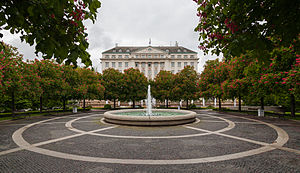
The Esplanade Zagreb Hotel is a historic luxury hotel in Zagreb, Croatia. It was built in 1925 to provide accommodation for passengers of the famous Orient Express train, which traveled between Paris and Istanbul.
Ministry of Economy and Sustainable Development (Croatia)
Government ministry in Croatia
Distance: Approx. 259 meters
Latitude and longitude: 45.799747,15.977114
The ministry of Economy of the Republic of Croatia (Croatian: Ministarstvo gospodarstva i održivog razvoja) is the ministry in the Government of Croatia which is in charge of the development of the economy, and conducting administrative and other tasks related to: industry, except food and tobacco industry, shipbuilding, energy, mining, trade, cooperatives, other than agricultural, small and medium businesses, trade, trade policy, and policy to protect domestic production; economic cooperation with foreign countries, involvement in European economic integration, the harmonization of activities in conjunction with the Croatian membership in the World Trade Organization and participation in multilateral trade negotiations in the framework of this organization, promotion of exports and foreign investment, the establishment and operation of free zones, systematic stimulation of entrepreneurship, state of market, supplies and prices, consumer protection, strategic stockpiles, the privatization of shares and stakes in the state owned companies, restructuring and rehabilitation of legal entities, safety at work.
Weather in this IP's area
fog
2 Celsius
-0 Celsius
-1 Celsius
3 Celsius
1014 hPa
91 %
1014 hPa
1000 hPa
200 meters
2.57 m/s
50 degree
100 %
06:59:12
16:23:19


