Country:
 Iceland
Region:
City:
Latitude and Longitude:
Time Zone:
Postal Code:
IP information under different IP Channel
ip-api
Country
Region
City
ASN
Time Zone
ISP
Blacklist
Proxy
Latitude
Longitude
Postal
Route
IPinfo
Country
Region
City
ASN
Time Zone
ISP
Blacklist
Proxy
Latitude
Longitude
Postal
Route
MaxMind
Country
Region
City
ASN
Time Zone
ISP
Blacklist
Proxy
Latitude
Longitude
Postal
Route
Luminati
Country
ISRegion
1
City
reykjavik
ASN
Time Zone
Atlantic/Reykjavik
ISP
Ljosleidarinn ehf
Latitude
Longitude
Postal
db-ip
Country
Region
City
ASN
Time Zone
ISP
Blacklist
Proxy
Latitude
Longitude
Postal
Route
ipdata
Country
Region
City
ASN
Time Zone
ISP
Blacklist
Proxy
Latitude
Longitude
Postal
Route
Popular places and events near this IP address
Menntaskólinn Hraðbraut
Private school in Reykjavík, Iceland
Distance: Approx. 1403 meters
Latitude and longitude: 64.12888889,-21.86694444
Menntaskólinn Hraðbraut (or Hraðbraut; meaning in Icelandic: speedway) was a privately run Icelandic secondary school that ran from 2003 to 2012. The school awarded a student degree after two years of study instead of the then standard four; the school's name reflected this express course.
Kópavogur College
Distance: Approx. 1230 meters
Latitude and longitude: 64.11083333,-21.895
Kópavogur College (Icelandic: Menntaskólinn í Kópavogi Icelandic pronunciation: [ˈmɛn̥taˌskouːlɪn i ˈkʰouːpaˌvɔijɪ]) is an upper-secondary school in Kópavogur, Iceland, founded on September 22, 1973.
Verzló
School in Reykjavík, Iceland
Distance: Approx. 1672 meters
Latitude and longitude: 64.12777778,-21.89638889
Verzlunarskóli Íslands, usually referred to as Verzló (official name in English: Commercial College of Iceland) is an Icelandic gymnasium. It was founded in 1905 and is the oldest private school in Iceland. The school is located in Reykjavík and has more than 900 students.

Elliðaár
Distance: Approx. 1680 meters
Latitude and longitude: 64.12166667,-21.84083333
The river Elliðaár (Icelandic pronunciation: [ˈɛtlɪːðaˌauːr̥], "Elliði's river") is situated in the Reykjavík area in the south-west of Iceland. Two small rivers have their source in the volcanic mountain range of Bláfjöll and stream down to Elliðavatn lake at the eastern suburban border of the city, its outlet forming the river. On their way, they pass through the nature reserve area of Heiðmörk.
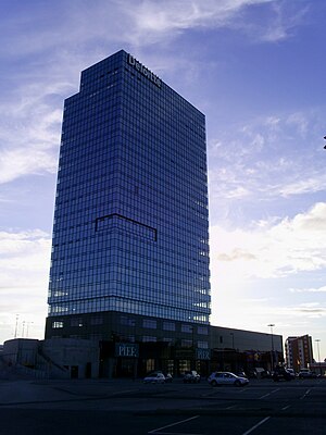
Smáratorg Tower
Office in Kópavogur, Iceland
Distance: Approx. 1578 meters
Latitude and longitude: 64.10277778,-21.88055556
Smáratorg 3 (Icelandic pronunciation: [ˈsmauːraˌtʰɔrk]) is an office and retail building in Iceland. It is the tallest building in Iceland, surpassing Hallgrímskirkja in height, and is the fourth-tallest architectural structure in the country after the masts of Naval Radio Transmitter Facility in Grindavík and longwave radio mast at Hellissandur (which is the tallest longwave radio mast in the world). The building is located in Smárahverfi, Kópavogur, where the shopping mall Smáralind is also located.
Hvassaleiti
Distance: Approx. 938 meters
Latitude and longitude: 64.125,-21.875
Hvassaleiti (Icelandic pronunciation: [ˈkʰvassaˌleiːtɪ]) is a neighbourhood in Reykjavík, the capital of Iceland (103, Reykjavík). Children there used to go to two schools Hvassaleitisskóli (founded in 1966) or Álftamýraskóli (founded in 1964). After their merger children attend Háaleitisskóli.
Hvassaleitisskóli
Distance: Approx. 1326 meters
Latitude and longitude: 64.12783333,-21.8825
Hvassaleitisskóli (also known colloquially as Hvassó) was an Icelandic elementary school located at Hvassaleiti in Reykjavík. The school was founded in 1966 and had around 240 students, 32 teachers and 6 other workers. It was merged with the Álftamýrarskóli school to form the Háaleitiskóli school.

Grímsbær
Distance: Approx. 621 meters
Latitude and longitude: 64.122115,-21.875314
Grímsbær (Icelandic pronunciation: [ˈkrimsˌpaiːr̥]) is a small shopping centre in the middle of Reykjavík, Iceland. Originally a two-story structure built into a hillside, in 2004 a third floor was built on top of the existing structure and the centre grew to around 2000 m2, which it remains to this day.
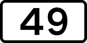
Route 49 (Iceland)
Distance: Approx. 1465 meters
Latitude and longitude: 64.12972222,-21.87555556
Nesbraut (Icelandic pronunciation: [ˈnɛsˌprœyːt]), or Route 49, is a major traffic artery in Reykjavík, Iceland. It is one of the two main roads running across Capital Region, the other being Kringlumýrarbraut. The name Nesbraut is not well known among locals as it is usually referred to by its main segments: Miklabraut [ˈmɪhklaˌprœyːt] and Hringbraut [ˈr̥iŋkˌprœyːt].

Háaleiti og Bústaðir
District in Capital, Iceland
Distance: Approx. 1432 meters
Latitude and longitude: 64.12916667,-21.87972222
Háaleiti og Bústaðir (Icelandic pronunciation: [ˈhauːaˌleiːtɪ ɔːɣ ˈpuːˌstaːðɪr̥]) is a district of Reykjavík, the capital of Iceland. Within the district are four neighbourhoods: Háaleiti proper, Kringla [ˈkʰriŋla], Gerði [ˈcɛrðɪ] and Fossvogur [ˈfɔsːˌvɔːɣʏr̥].

Víkingsvöllur
Football stadium in Reykjavík, Iceland
Distance: Approx. 888 meters
Latitude and longitude: 64.11638889,-21.85513889
Víkingsvöllur (Icelandic pronunciation: [ˈviːciŋsˌvœtlʏr̥]) is a football stadium in Reykjavík, Iceland.
Borgarspítalinn
Hospital in Reykjavík, Iceland
Distance: Approx. 985 meters
Latitude and longitude: 64.1228146,-21.88782277
Borgarspítalinn (English: City Hospital) was an Icelandic hospital located in Fossvogur, Reykjavík from 1967 until 1996 when it merged with St. Jósefsspítali to form Reykjavík Hospital. Reykjavík Hospital then merged with Landspítali in 2000 to form the National University Hospital of Iceland.
Weather in this IP's area
overcast clouds
9 Celsius
6 Celsius
7 Celsius
9 Celsius
975 hPa
59 %
975 hPa
972 hPa
10000 meters
6.05 m/s
9.92 m/s
22 degree
100 %
08:27:33
17:57:16