Country:
 Iceland
Region:
City:
Latitude and Longitude:
Time Zone:
Postal Code:
IP information under different IP Channel
ip-api
Country
Region
City
ASN
Time Zone
ISP
Blacklist
Proxy
Latitude
Longitude
Postal
Route
IPinfo
Country
Region
City
ASN
Time Zone
ISP
Blacklist
Proxy
Latitude
Longitude
Postal
Route
MaxMind
Country
Region
City
ASN
Time Zone
ISP
Blacklist
Proxy
Latitude
Longitude
Postal
Route
Luminati
Country
ISRegion
1
City
reykjavik
ASN
Time Zone
Atlantic/Reykjavik
ISP
Ljosleidarinn ehf
Latitude
Longitude
Postal
db-ip
Country
Region
City
ASN
Time Zone
ISP
Blacklist
Proxy
Latitude
Longitude
Postal
Route
ipdata
Country
Region
City
ASN
Time Zone
ISP
Blacklist
Proxy
Latitude
Longitude
Postal
Route
Popular places and events near this IP address
National and University Library of Iceland
National library of Iceland
Distance: Approx. 1435 meters
Latitude and longitude: 64.14277778,-21.95055556
Landsbókasafn Íslands – Háskólabókasafn (Icelandic: [ˈlan(t)sˌpouːkaˌsapn ˈistlan(t)s – ˈhauːˌskouːlaˌpouːkaˌsapn̥]; English: The National and University Library of Iceland) is the national library of Iceland which also functions as the university library of the University of Iceland. The library was established on December 1, 1994, in Reykjavík, Iceland, with the merger of the former national library, Landsbókasafn Íslands (est. 1818), and the university library (formally est.

Árnagarður
Distance: Approx. 1497 meters
Latitude and longitude: 64.13888889,-21.95138889
Árnagarður (Icelandic pronunciation: [ˈau(r)tnaˌkarðʏr̥]) is a building in Reykjavík, Iceland, located on the campus of the University of Iceland. It is named after the 18th century scholar Árni Magnússon, and houses the Árni Magnússon Institute for Icelandic Studies. Most of the building is used for staff offices and classrooms, but it also houses a small cafeteria.
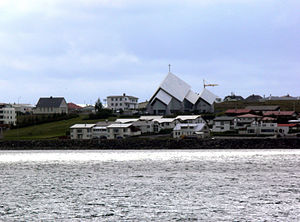
Seltjarnarnes
Municipality and Town in Capital Region, Iceland
Distance: Approx. 1500 meters
Latitude and longitude: 64.15416667,-22
Seltjarnarnes (Icelandic pronunciation: [ˈsɛlˌtʰja(r)tnarˌnɛːs] ) is a town in the Capital Region of Iceland. The municipality is located on a peninsula, bordered only by Reykjavík to the east. It took on its current political form shortly after the Second World War and was formally created as a township in 1947.
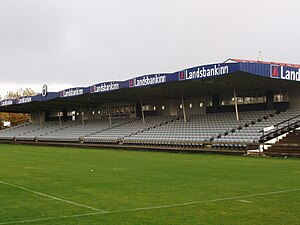
KR-völlur
Football stadium in Reykjavík, Iceland
Distance: Approx. 628 meters
Latitude and longitude: 64.14568333,-21.96772778
KR-völlur is a football stadium in Reykjavík, Iceland. It is currently used mostly for football matches and has been the home stadium of Knattspyrnufélag Reykjavíkur since 1984. The stadium holds about 2,700 people and is located at Kaplaskjólsvegur in West Reykjavík.

University of Iceland VR
Distance: Approx. 1358 meters
Latitude and longitude: 64.138908,-21.954482
The VR buildings are a part of the campus of the University of Iceland. VR is short for Verkfræði og Raunvísindi (English: Engineering and Natural Science) The buildings were constructed in the 1970s and (as the name implies) serve as centres for studies in engineering and natural science at the University of Iceland. VR I houses the experimental labs while VR II houses lecture halls and classrooms.
Árni Magnússon Institute for Icelandic Studies
Academic institute in Reykjavík
Distance: Approx. 1497 meters
Latitude and longitude: 64.13888889,-21.95138889
The Árni Magnússon Institute for Icelandic Studies (Icelandic: Stofnun Árna Magnússonar í íslenskum fræðum [ˈstɔpnʏn ˈau(r)tna ˈmaknusˌsɔːnar iː ˈistlɛnskʏm ˈfraiːðʏm]) is an institute of the Ministry of Education, Science and Culture of Iceland which conducts research in Icelandic and related academic studies, in particular the Icelandic language and Icelandic literature, to disseminate knowledge in those areas, and to protect and develop the collections that it possesses or those placed in its care. It is named after Árni Magnússon, a 17th–18th century collector of medieval Icelandic manuscripts. The Árni Magnússon Institute (Stofnun Árna Magnússonar) was an academic institute located in Reykjavík, Iceland.

University of Iceland Main Building
Distance: Approx. 1529 meters
Latitude and longitude: 64.14055556,-21.94944444
The University of Iceland Main Building (Icelandic: Aðalbygging Háskóla Íslands [ˈaːðalˌpɪcciŋk ˈhauːˌskouːla ˈistlan(t)s]) is the central building of the University of Iceland campus on Suðurgata in Reykjavík, Iceland. It was designed by Icelandic state architect Guðjón Samúelsson and its construction was completed in 1940. Today, the building is one of the more noticeable landmarks in Reykjavík.

Vesturbær
District in Reykjavík, Iceland
Distance: Approx. 1423 meters
Latitude and longitude: 64.148581,-21.952723
Vesturbær (Icelandic pronunciation: [ˈvɛstʏrˌpaiːr̥]) is a district in Reykjavík in Iceland, comprising eight neighbourhoods west of the city center: Gamli Vesturbær [ˈkamlɪ ˈvɛstʏrˌpaiːr̥], Bráðræðisholt [ˈprauðˌraiːðɪsˌhɔl̥t], Grandahverfi [ˈkrantaˌkʰvɛrvɪ], Hagahverfi [ˈhaːɣaˌkʰvɛrvɪ], Melar [ˈmɛːlar̥], Skjól [ˈscouːl̥], Grímsstaðaholt [ˈkrimsˌstaːðaˌhɔl̥t], Skildinganes [ˈscɪltiŋkaˌnɛːs] and Litli Skerjafjörður [ˈlɪhtlɪ ˌscɛrjaˌfjœrðʏr̥].

Valhúsaskóli
School in Seltjarnarnes, Iceland
Distance: Approx. 1105 meters
Latitude and longitude: 64.151083,-21.995705
Valhúsaskóli, commonly referred to as Való, is a middle school located in Seltjarnarnes, Iceland. Valhúsaskóli enrolls students grades 7–10.
Íþróttafélagið Grótta
Icelandic sports club
Distance: Approx. 1038 meters
Latitude and longitude: 64.15016667,-21.99583333
Íþróttafélagið Grótta (English: Grótta Sports Club; pronounced [ˈkrouhta]) is an Icelandic sports club based in the town of Seltjarnarnes, in the Capital Region. The club is best known for its women's handball team that won the national championship in 2015 and 2016, but also has departments for gymnastics, football and powerlifting.
Endurmenntun Háskóla Íslands
School in Reykjavík, Iceland
Distance: Approx. 1269 meters
Latitude and longitude: 64.139598,-21.955787
Endurmenntun Háskóla Íslands is a continuing education centre operated by the University of Iceland. Unlike its parent institution, it does not receive public funding and it entirely funded by school fees. It offers a variety of career enhancement- and personal enrichment courses in fields such as finance, administration, information technology, education, tourism, language and culture.

Vesturbæjarlaug
Swimming pool in Iceland
Distance: Approx. 827 meters
Latitude and longitude: 64.1444,-21.963
Vesturbæjarlaug, also known as Sundlaug Vesturbæjar, is a swimming pool in the Vesturbær district in Reykjavík, the capital of Iceland. It has a 12.5×25 m geothermally heated outdoor swimming pool with depth ranging from 0.9 to 3.9 m. There is also an adjacent playpool, several hot tubs, a cold tub, outdoor showers, a steam room and saunas.
Weather in this IP's area
scattered clouds
7 Celsius
5 Celsius
7 Celsius
7 Celsius
975 hPa
76 %
975 hPa
975 hPa
10000 meters
3.09 m/s
350 degree
40 %
08:28:04
17:57:35