Country:
Region:
City:
Latitude and Longitude:
Time Zone:
Postal Code:
IP information under different IP Channel
ip-api
Country
Region
City
ASN
Time Zone
ISP
Blacklist
Proxy
Latitude
Longitude
Postal
Route
Luminati
Country
Region
13
City
gondomar
ASN
Time Zone
Europe/Lisbon
ISP
Nos Comunicacoes, S.A.
Latitude
Longitude
Postal
IPinfo
Country
Region
City
ASN
Time Zone
ISP
Blacklist
Proxy
Latitude
Longitude
Postal
Route
db-ip
Country
Region
City
ASN
Time Zone
ISP
Blacklist
Proxy
Latitude
Longitude
Postal
Route
ipdata
Country
Region
City
ASN
Time Zone
ISP
Blacklist
Proxy
Latitude
Longitude
Postal
Route
Popular places and events near this IP address

Gondomar, Portugal
Municipality in Norte, Portugal
Distance: Approx. 628 meters
Latitude and longitude: 41.15,-8.53333333
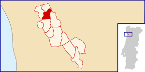
Gondomar (Portuguese pronunciation: [ɡõduˈmaɾ] ) is a municipality located in the east of Portugal's Porto Metropolitan Area and 7 km from central Porto. The population in 2011 was 168,027, in an area of 131.86 km2. Gondomar's mayor is Marco Martins.

Campanhã
Civil parish in Norte, Portugal
Distance: Approx. 4360 meters
Latitude and longitude: 41.157,-8.579
Campanhã (Portuguese pronunciation: [kɐ̃pɐˈɲɐ̃]) is a Portuguese freguesia ("civil parish"), located in the city of Porto. The population in 2011 was 32,659, in an area of 8.04 km². Located there is the Campanhã station, the most important in Porto.
Estádio de São Miguel (Gondomar)
Distance: Approx. 1460 meters
Latitude and longitude: 41.13595556,-8.54175833
Estadio de São Miguel is a multi-use stadium in Gondomar, Portugal. It is currently used mostly for football matches and is the home stadium of fourth-tier Gondomar SC. The stadium is able to hold around 2500 people.

Rio Tinto (Gondomar)
Civil parish in Norte, Portugal
Distance: Approx. 4462 meters
Latitude and longitude: 41.178,-8.56
Rio Tinto (European Portuguese pronunciation: [ˈʁi.u ˈtĩtu]; "Colored River") is a Portuguese city and parish located in Gondomar Municipality, in northern Portugal. The population in 2011 was 50,713, in an area of 9.38 km2. Rio Tinto, which in Portuguese means red river, was elevated to city status in 1995, and the city of Rio Tinto includes two parishes (freguesias): Baguim do Monte and Rio Tinto, with a total of 65,000 inhabitants, being the most populous city in Gondomar municipality, and third largest in the Greater Porto agglomeration.
Avintes
Civil parish in Norte, Portugal
Distance: Approx. 4622 meters
Latitude and longitude: 41.107,-8.551
Avintes is a Portuguese civil parish in the municipality of Vila Nova de Gaia. The population in 2021 was 10,838, in an area of 8.82 km2. It is known in Portugal as "Terra da Broa", meaning "Land of the Broa", referring to the Broa de Avintes, a typical farmhouse bread widely consumed in Northern Portugal, which originated in Avintes.

Valbom
Civil parish in Norte, Portugal
Distance: Approx. 3396 meters
Latitude and longitude: 41.1333,-8.5667
Valbom is a small village and a former civil parish in the municipality of Gondomar, Portugal. In 2013, the parish merged into the new parish Gondomar (São Cosme), Valbom e Jovim. It has about 15,000 residents.

Fânzeres
Civil parish in Norte, Portugal
Distance: Approx. 2412 meters
Latitude and longitude: 41.16666667,-8.53333333
Fânzeres is a town and a former civil parish in the municipality of Gondomar, Portugal. In 2013, the parish merged into the new parish Fânzeres e São Pedro da Cova. Its population is around 20,000.

Freixo Bridge
Bridge
Distance: Approx. 4211 meters
Latitude and longitude: 41.14194444,-8.57944444
The Freixo Bridge (Portuguese: Ponte do Freixo) which was inaugurated in 1995 is a Portuguese bridge over the Douro river, connecting Vila Nova de Gaia and Porto. The purpose of its construction was to create an alternative to Arrábida and D. Luis I bridges. The designers of the bridge are António Reis and Daniel de Sousa.

Palácio do Freixo
Palace in Campanhã, Portugal
Distance: Approx. 3811 meters
Latitude and longitude: 41.1425,-8.57472222
The Palace of Freixo (Portuguese: Palácio do Freixo) is a former-residence in the civil parish of Campanhã, in the northern Portuguese city of Porto.
Fountain of the Virtues
Distance: Approx. 883 meters
Latitude and longitude: 41.14472222,-8.51888889
The Fountain of the Virtues (Portuguese: Chafariz das Virtudes) is a fountain in the civil parish of Cedofeita, Santo Ildefonso, Sé, Miragaia, São Nicolau e Vitória, in the municipality of Porto.
Fânzeres e São Pedro da Cova
Civil parish in Norte, Portugal
Distance: Approx. 2324 meters
Latitude and longitude: 41.166,-8.527
Fânzeres e São Pedro da Cova is a civil parish in the municipality of Gondomar, Portugal. It was formed in 2013 by the merger of the former parishes Fânzeres and São Pedro da Cova. The population in 2011 was 39,586, in an area of 21.96 km².
Gondomar (São Cosme), Valbom e Jovim
Civil parish in Norte, Portugal
Distance: Approx. 724 meters
Latitude and longitude: 41.139,-8.532
Gondomar (São Cosme), Valbom e Jovim is a civil parish in the municipality of Gondomar, Portugal. It was formed in 2013 by the merger of the former parishes Gondomar (São Cosme), Valbom and Jovim. The population in 2011 was 48,600, in an area of 23.32 km2.
Weather in this IP's area
broken clouds
17 Celsius
17 Celsius
17 Celsius
18 Celsius
1018 hPa
88 %
1018 hPa
1004 hPa
6000 meters
1.54 m/s
250 degree
75 %
07:26:01
17:13:01


