Country:
 Portugal
Region:
City:
Latitude and Longitude:
Time Zone:
Postal Code:
IP information under different IP Channel
ip-api
Country
Region
City
ASN
Time Zone
ISP
Blacklist
Proxy
Latitude
Longitude
Postal
Route
IPinfo
Country
Region
City
ASN
Time Zone
ISP
Blacklist
Proxy
Latitude
Longitude
Postal
Route
MaxMind
Country
Region
City
ASN
Time Zone
ISP
Blacklist
Proxy
Latitude
Longitude
Postal
Route
Luminati
Country
PTRegion
13
City
sobrado
ASN
Time Zone
Europe/Lisbon
ISP
Nos Comunicacoes, S.A.
Latitude
Longitude
Postal
db-ip
Country
Region
City
ASN
Time Zone
ISP
Blacklist
Proxy
Latitude
Longitude
Postal
Route
ipdata
Country
Region
City
ASN
Time Zone
ISP
Blacklist
Proxy
Latitude
Longitude
Postal
Route
Popular places and events near this IP address

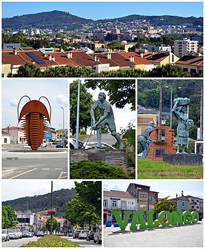
Valongo
Municipality in Norte, Portugal
Distance: Approx. 4439 meters
Latitude and longitude: 41.18333333,-8.5
Valongo (Portuguese pronunciation: [vɐˈlõɡu] ) is a Portuguese municipality located in the District of Porto and 10 km from Porto, in the northern region of Portugal. The municipality area consists of 75.12 km² and 93 858 inhabitants (2011), and it is subdivided into four parishes: Alfena, Campo e Sobrado, Ermesinde and Valongo. The municipality is limited to the north by the municipality of Santo Tirso, to the northeast by Paços de Ferreira, to the east by Paredes, to the southwest by Gondomar and to the west by Maia.
Recarei
Civil parish in Norte, Portugal
Distance: Approx. 6228 meters
Latitude and longitude: 41.16,-8.425
Recarei is a town in the Porto district of Portugal which forms part of the municipality of Paredes. The population in 2011 was 4,631, in an area of 14.60 km2 (5.64 sq mi). It has the administrative status of a freguesia or parish.
Gandra (Paredes)
Civil parish in Norte, Portugal
Distance: Approx. 2588 meters
Latitude and longitude: 41.193,-8.438
Gandra (Portuguese pronunciation: [ˈɡɐ̃dɾɐ]) is a city and parish in Portugal, part of the municipality of Paredes. The population in 2011 was 6,974, in an area of 11.76 km2. It was promoted to a city in 2003.
Rebordosa
Civil parish in Norte, Portugal
Distance: Approx. 4181 meters
Latitude and longitude: 41.22,-8.412
Rebordosa (Portuguese pronunciation: [ʁɨβuɾˈðɔzɐ]) is a civil parish in the municipality of Paredes, in the northern subregion of Tâmega. The population in 2011 was 9,106, in an area of 10.76 km2. It is approximately 20 kilometres (12 mi) east of the centre of Porto.
Astromil
Civil parish in Norte, Portugal
Distance: Approx. 3775 meters
Latitude and longitude: 41.199,-8.417
Astromil is a Portuguese parish of the municipality of Paredes. The population in 2011 was 1,086, in an area of 1.93 km2.
Baltar (Paredes)
Civil parish in Norte, Portugal
Distance: Approx. 6293 meters
Latitude and longitude: 41.193,-8.388
Baltar is a parish in Paredes Municipality in Portugal. The population as of the 2021 census was 4,720, down from 4,818, in 2011. It covers an area of 7.41 km².
Agrela (Santo Tirso)
Civil parish in Norte, Portugal
Distance: Approx. 5380 meters
Latitude and longitude: 41.257,-8.471
Agrela is a civil parish in the municipality of Santo Tirso, Portugal. The population in 2011 was 1,584, in an area of 6.99 km2.
Água Longa
Civil parish in Norte, Portugal
Distance: Approx. 5705 meters
Latitude and longitude: 41.255,-8.491
Água Longa is a civil parish in the municipality of Santo Tirso, Portugal. The population in 2011 was 2,207, in an area of 12.87 km2.

Battle of Ponte Ferreira
Distance: Approx. 4439 meters
Latitude and longitude: 41.18333333,-8.5
The Battle of Ponte Ferreira, fought on 22–23 July 1832, was the first major battle of the Portuguese Civil War between the forces of Dom Pedro, ex-Emperor of Brazil and Regent for his daughter Maria da Glória, and the army of his brother Dom Miguel, who had usurped the throne of Portugal. Though technically a victory for Pedro's forces, it gave him no lasting advantage because the enemy were not pursued and were able to return in full strength, as a result of which he was besieged in Porto for an entire year.

Alfena
Civil parish in Norte, Portugal
Distance: Approx. 6312 meters
Latitude and longitude: 41.238,-8.525
Alfena is a Portuguese city and parish in the municipality of Valongo, Portugal. The population in 2010 was 18,130, in an area of 15.7 km2.
Lordelo (Paredes)
Distance: Approx. 4894 meters
Latitude and longitude: 41.2336,-8.4111
Lordelo, often known as São Salvador de Lordelo, is a city located in Paredes Municipality, Porto District, Portugal. The former town was elevated to the status of a city in 2003; although it was proposed at that time that the name should be changed to São Salvador de Lordelo the law as enacted retained the name of Lordelo.
Valongo (parish)
Civil parish in Norte, Portugal
Distance: Approx. 3792 meters
Latitude and longitude: 41.191,-8.498
Valongo is a civil parish in the municipality (concelho) of Valongo, in continental Portugal. The population in 2021 was 25882, in an area of 20.24 km2. Valongo is most famous for its mountains and its bread.
Weather in this IP's area
overcast clouds
19 Celsius
19 Celsius
19 Celsius
20 Celsius
1020 hPa
90 %
1020 hPa
1007 hPa
10000 meters
1.25 m/s
1.98 m/s
295 degree
100 %
07:29:39
19:17:38