Country:
 Portugal
Region:
City:
Latitude and Longitude:
Time Zone:
Postal Code:
IP information under different IP Channel
ip-api
Country
Region
City
ASN
Time Zone
ISP
Blacklist
Proxy
Latitude
Longitude
Postal
Route
IPinfo
Country
Region
City
ASN
Time Zone
ISP
Blacklist
Proxy
Latitude
Longitude
Postal
Route
MaxMind
Country
Region
City
ASN
Time Zone
ISP
Blacklist
Proxy
Latitude
Longitude
Postal
Route
Luminati
Country
PTRegion
15
City
almada
ASN
Time Zone
Europe/Lisbon
ISP
Nos Comunicacoes, S.A.
Latitude
Longitude
Postal
db-ip
Country
Region
City
ASN
Time Zone
ISP
Blacklist
Proxy
Latitude
Longitude
Postal
Route
ipdata
Country
Region
City
ASN
Time Zone
ISP
Blacklist
Proxy
Latitude
Longitude
Postal
Route
Popular places and events near this IP address

Almada
Municipality in Lisbon, Portugal
Distance: Approx. 378 meters
Latitude and longitude: 38.68027778,-9.15833333
Almada (European Portuguese pronunciation: [alˈmaðɐ] ) is a city and a municipality in Portugal, located on the southern margin of the Tagus River, on the opposite side of the river from Lisbon. The two cities are connected by the 25 de Abril Bridge. The population of the municipality in 2011 was 174,030, in an area of 70.21 km2.

25 de Abril Bridge
Suspension bridge in Lisbon, Portugal
Distance: Approx. 1518 meters
Latitude and longitude: 38.68916667,-9.17694444
The 25 de Abril Bridge (Portuguese: Ponte 25 de Abril, 25th of April Bridge, Portuguese pronunciation: [ˈpõtɨ ˈvĩtɨ (i) ˈsĩku dɨ ɐˈbɾil]) is a suspension bridge connecting the city of Lisbon, capital of Portugal, to the municipality of Almada on the left (south) bank of the Tagus River. It has a main span length of 1,013 metres (3,323 ft), making it the 48th longest suspension bridge in the world. At the time of its inauguration in 1966, the bridge was named Salazar Bridge (Ponte Salazar), after Portuguese Prime Minister António de Oliveira Salazar, who ordered its construction.
Almada, Cova da Piedade, Pragal e Cacilhas
Civil parish in Lisbon, Portugal
Distance: Approx. 419 meters
Latitude and longitude: 38.68,-9.158
Almada, Cova da Piedade, Pragal e Cacilhas is a civil parish in the municipality of Almada, in the Portuguese district of Setúbal. It was formed in 2013 from the merger of the former parishes of Almada, Cova da Piedade, Pragal and Cacilhas, and covers an area of 6.15 square kilometres (66,200,000 sq ft). In 2011 there were 49,661 inhabitants in the reconstituted parish.

Cacilhas
Civil parish in Lisbon, Portugal
Distance: Approx. 1210 meters
Latitude and longitude: 38.686,-9.149
Cacilhas (European Portuguese: [kɐˈsiʎɐʃ]) is a former civil parish in the municipality of Almada, Lisbon metropolitan area, Portugal. In 2013, the parish merged into the new parish Almada, Cova da Piedade, Pragal e Cacilhas. The population in 2011 was 6,017, in an area of 1.09 km2.
Cova da Piedade
Civil parish in Lisbon, Portugal
Distance: Approx. 1042 meters
Latitude and longitude: 38.674,-9.156
Cova da Piedade (European Portuguese: [ˈkɔvɐ ðɐ pjɛˈðaðɨ]) is a former civil parish in the municipality of Almada, Lisbon metropolitan area, Portugal. In 2013, the parish merged into the new parish Almada, Cova da Piedade, Pragal e Cacilhas. The population in 2011 was 19,904, in an area of 1.42 km2.

Christ the King (Almada)
Church in Setúbal District, Portugal
Distance: Approx. 900 meters
Latitude and longitude: 38.67861,-9.17134
The Sanctuary of Christ the King (Portuguese: Santuário de Cristo Rei) is a Catholic monument and shrine dedicated to the Sacred Heart of Jesus Christ overlooking the city of Lisbon situated in Almada, in Portugal. It was inspired by the Christ the Redeemer statue of Rio de Janeiro, in Brazil, after the Cardinal Patriarch of Lisbon visited that monument. The project was inaugurated on 17 May 1959.

Dom Fernando II e Glória
Distance: Approx. 1381 meters
Latitude and longitude: 38.6860763,-9.1469498
Dom Fernando II e Glória is a wooden-hulled, 50-gun frigate of the Portuguese Navy. She was launched in 1843 and made her maiden voyage in 1845. Built at the shipyard of Daman in Portuguese India, it was Portugal's last sailing warship to be built and also the last ship that undertook the Carreira da Índia (India Run), a regular military line that connected Portugal to its colonies in India since the beginning of the 16th century.
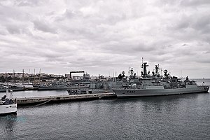
Lisbon Naval Base
Main installation base of the Portuguese Navy
Distance: Approx. 1760 meters
Latitude and longitude: 38.6692,-9.1503
The Lisbon Naval Base (Portuguese: Base Naval de Lisboa), is the main installation and operational base of the Portuguese Navy. Located at the former Royal Estate of Alfeite on the south bank of the Tagus river's estuary, near the city of Almada, the installation is sometimes referred to as the Alfeite Naval Base. Most of the Portuguese Naval fleet ships are based at Alfeite, as well as many of its administrative, training and support services.

Campo de Jogos do Pragal
Distance: Approx. 859 meters
Latitude and longitude: 38.6769,-9.1693
Campo de Jogos do Pragal is the home soccer stadium of Almada Atlético Clube, a Portuguese sports club based in Almada, Portugal. The stadium is overlooked by and adjacent to the surrounding area of the Cristo Rei monument.

Boca do Vento Elevator
Elevator in Almada, Portugal
Distance: Approx. 398 meters
Latitude and longitude: 38.68466667,-9.15880556
The Boca do Vento Elevator (Portuguese: Elevador da Boca do Vento), is a public elevator in the municipality of Almada, in Portugal. Opening to the public in 2000, it was designed by Portuguese sculptor José Aurélio and architects Fidalgo Mineiro, Helena Moreira e Anabela Felícia.

Castle of Almada
Medieval castle in Cova da Piedade, Setúbal, Portugal
Distance: Approx. 615 meters
Latitude and longitude: 38.68473056,-9.15577778
The Castle of Almada (Portuguese: Castelo de Almada) is a medieval castle located in the civil parish of Almada, Cova da Piedade, Pragal e Cacilhas, in the municipality of Almada, Portuguese Setúbal.
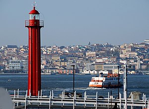
Cacilhas Lighthouse
Lighthouse near Lisbon, Portugal
Distance: Approx. 1510 meters
Latitude and longitude: 38.68805556,-9.14638889
The Cacilhas Lighthouse (Portuguese: Farol de Cacilhas) is situated in the parish of Cacilhas, in the municipality of Almada, on the opposite side of the Tagus River from the Portuguese capital of Lisbon. Although not functioning, it was restored in 2009 as it is considered to be an important part of the area's heritage. The lighthouse started operating on 31 December 1885 for the purpose of indicating the southern limit of the anchorage area on the River Tagus, an area where fog is common.
Weather in this IP's area
clear sky
20 Celsius
20 Celsius
19 Celsius
21 Celsius
1019 hPa
76 %
1019 hPa
1015 hPa
10000 meters
7.72 m/s
10 degree
07:31:44
19:21:11