Country:
 Portugal
Region:
City:
Latitude and Longitude:
Time Zone:
Postal Code:
IP information under different IP Channel
ip-api
Country
Region
City
ASN
Time Zone
ISP
Blacklist
Proxy
Latitude
Longitude
Postal
Route
IPinfo
Country
Region
City
ASN
Time Zone
ISP
Blacklist
Proxy
Latitude
Longitude
Postal
Route
MaxMind
Country
Region
City
ASN
Time Zone
ISP
Blacklist
Proxy
Latitude
Longitude
Postal
Route
Luminati
Country
PTRegion
13
City
vilanovadegaia
ASN
Time Zone
Europe/Lisbon
ISP
Nos Comunicacoes, S.A.
Latitude
Longitude
Postal
db-ip
Country
Region
City
ASN
Time Zone
ISP
Blacklist
Proxy
Latitude
Longitude
Postal
Route
ipdata
Country
Region
City
ASN
Time Zone
ISP
Blacklist
Proxy
Latitude
Longitude
Postal
Route
Popular places and events near this IP address
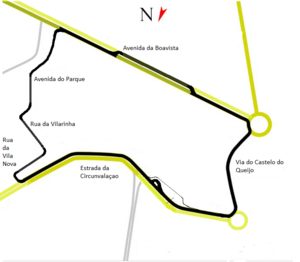
Circuito da Boavista
Street circuit in Portugal
Distance: Approx. 1384 meters
Latitude and longitude: 41.17047222,-8.67325
Circuito da Boavista is a street circuit in Porto, Portugal, which was used twice for the Formula One Portuguese Grand Prix. The original course began at the harbor-front "Esplanada do Rio de Janeiro", continued on "Avenida da Boavista", (hence the circuit's name), and then twisted its way through small neighborhoods back to the start-finish line. The first Grand Prix was held in 1958, and saw an act of sportsmanship by Stirling Moss.

Aldoar
Civil parish in Norte, Portugal
Distance: Approx. 1527 meters
Latitude and longitude: 41.171,-8.671
Aldoar (Portuguese pronunciation: [alduˈaɾ]) is a former civil parish in the municipality of Porto, Portugal. In 2013, the parish merged into the new parish Aldoar, Foz do Douro e Nevogilde. The population in 2011 was 12,843, in an area of 2.41 km².

Leixões
Distance: Approx. 1259 meters
Latitude and longitude: 41.183,-8.7
The Port of Leixões (Portuguese: Porto de Leixões, pronounced [lɐjˈʃõjʃ]) is one of Portugal's major seaports, located 4 km north of the mouth of the Douro River, in Matosinhos municipality, near the city of Porto. Leixões Sport Club, commonly known simply as Leixões, is Matosinhos' sports club. The Port of Leixões is the largest port infrastructure in the Northern Region of Portugal and one of the most important in the Country.
Jakob Maersk oil spill
Distance: Approx. 1124 meters
Latitude and longitude: 41.1807645,-8.6998633
Jakob Maersk was an oil tanker registered in Denmark that struck a sand bank on January 29, 1975 while entering the port of Leixões, Portugal, causing a major oil spill. Built in 1966, the tanker was owned by Maerskline Navigation Company, a subsidiary of A.P. Moller, and contracted by Shell Oil Company, consisting of a crew of seventeen at the time of the accident. Seven of those seventeen crew members died during the explosion.
Fort of São Francisco Xavier
Distance: Approx. 857 meters
Latitude and longitude: 41.169,-8.69
Fort of São Francisco Xavier (Portuguese: Forte de São Francisco Xavier) is a fortification situated along the coast of the civil parish of Nevogilde in the northern Portuguese municipality of Porto.

Sea Life Porto
Zoo in Porto, Portugal
Distance: Approx. 941 meters
Latitude and longitude: 41.16805556,-8.68722222
Sea Life Porto is an aquarium located in Porto, Portugal. It opened on 15 June 2009 and is one of the Sea Life Centres in Europe, which are owned by Merlin Entertainments.

Matosinhos
Municipality in Norte, Portugal
Distance: Approx. 1281 meters
Latitude and longitude: 41.18333333,-8.7
Matosinhos (Portuguese pronunciation: [mɐtuˈziɲuʃ] ) is a city and a municipality in the district of Porto in Portugal. The municipality covers an area of approximately 62.42 square kilometres (24.10 sq mi) and in 2011, it hosted a population 172,557 people. It is bordered by the municipalities of Porto to the south, Maia to the east and Vila do Conde to the north and the Atlantic Ocean lies to its west.

She Changes
Sculpture by Janet Echelman
Distance: Approx. 355 meters
Latitude and longitude: 41.1734,-8.6887
She Changes, known locally as anémona (the anemone), is a sculpture designed by artist Janet Echelman for the cities of Porto and Matosinhos, Northern Portugal. The installation consists of three steel poles, cables, a 20-ton steel ring and a net structure of varying densities and colors. The sculpture is Echelman's first permanent public art installation.
Matosinhos e Leça da Palmeira
Civil parish in Norte, Portugal
Distance: Approx. 1170 meters
Latitude and longitude: 41.187,-8.687
Matosinhos e Leça da Palmeira is a civil parish in the municipality of Matosinhos, Northern Portugal. It was formed in 2013 by the merger of the former parishes Matosinhos and Leça da Palmeira. The population in 2011 was 49,486, in an area of 12.16 km².
Aldoar, Foz do Douro e Nevogilde
Civil parish in Norte, Portugal
Distance: Approx. 1527 meters
Latitude and longitude: 41.171,-8.671
Aldoar, Foz do Douro e Nevogilde is a civil parish in the municipality of Porto, Portugal. It was formed in 2013 by the merger of the former parishes Aldoar, Foz do Douro and Nevogilde. The population in 2011 was 28,858, in an area of 6.27 km².

Porto Leixões Cruise Terminal
Distance: Approx. 1207 meters
Latitude and longitude: 41.17716667,-8.70208333
Porto Leixões Cruise Terminal is a purpose built terminal for ocean-going passenger ships built by the Port Authority of Douro, Porto, Portugal. The terminal was opened on the 23 July 2015.
Colégio Luso-Internacional do Porto
Private international school in Porto, Portugal
Distance: Approx. 1435 meters
Latitude and longitude: 41.1733372,-8.6710958
The Colégio Luso-Internacional do Porto (abbreviated as CLIP; Portuguese for Luso-International School of Porto), officially known in English as the Oporto International School, is a private international school in Porto, Portugal.
Weather in this IP's area
overcast clouds
19 Celsius
19 Celsius
19 Celsius
20 Celsius
1020 hPa
93 %
1020 hPa
1019 hPa
10000 meters
0.51 m/s
0.65 m/s
308 degree
98 %
07:30:33
19:18:33