Country:
 Great Britain
Region:
City:
Latitude and Longitude:
Time Zone:
Postal Code:
IP information under different IP Channel
ip-api
Country
Region
City
ASN
Time Zone
ISP
Blacklist
Proxy
Latitude
Longitude
Postal
Route
IPinfo
Country
Region
City
ASN
Time Zone
ISP
Blacklist
Proxy
Latitude
Longitude
Postal
Route
MaxMind
Country
Region
City
ASN
Time Zone
ISP
Blacklist
Proxy
Latitude
Longitude
Postal
Route
Luminati
Country
GBRegion
eng
City
manchester
ASN
Time Zone
Europe/London
ISP
iNES GROUP SRL
Latitude
Longitude
Postal
db-ip
Country
Region
City
ASN
Time Zone
ISP
Blacklist
Proxy
Latitude
Longitude
Postal
Route
ipdata
Country
Region
City
ASN
Time Zone
ISP
Blacklist
Proxy
Latitude
Longitude
Postal
Route
Popular places and events near this IP address
XFM Manchester
Former British radio station
Distance: Approx. 154 meters
Latitude and longitude: 53.4802,-2.2386
XFM Manchester was an Independent Local Radio station broadcasting alternative and indie music to Manchester in North West England. It built on the brand and format established by XFM London. The majority of programming was shared but some was produced specifically for Manchester.

Piccadilly Gardens
Public park in Manchester, England
Distance: Approx. 37 meters
Latitude and longitude: 53.48111111,-2.23722222
Piccadilly Gardens is a green space in Manchester city centre, England, on the edge of the Northern Quarter. It takes its name from the adjacent street, Piccadilly, which runs across the city centre from Market Street to London Road. The gardens also contain a bus station and a tram stop.

Manchester Piccadilly Gardens bus station
Bus station in Manchester, England
Distance: Approx. 93 meters
Latitude and longitude: 53.48032,-2.23751
Manchester Piccadilly Gardens bus station, often abbreviated to Piccadilly Gardens, is one of two main bus stations in Manchester city centre. Adjacent is a Manchester Metrolink station named Piccadilly Gardens. The majority of the stands are located between Piccadilly Gardens and the Piccadilly Plaza, where buses for south or west Manchester usually begin or end their route.

City Tower, Manchester
Office building in Manchester, England
Distance: Approx. 135 meters
Latitude and longitude: 53.48027778,-2.23833333
City Tower (formerly Sunley House) is a 30-storey high-rise office building situated in the Piccadilly Gardens area of Manchester city centre in England. As of 2023, it is the second-tallest office building in Manchester after the CIS Tower (118 m (387 ft)), the third-tallest outside London after CIS Tower and 103 Colmore Row in Birmingham (108 m (354 ft)), and the 16th-tallest building in Greater Manchester, with a roof height of 107 m (351 ft).

Mosley Street tram stop
Former Manchester Metrolink tram stop
Distance: Approx. 154 meters
Latitude and longitude: 53.4808,-2.239
Mosley Street was a tram stop in the City Zone (now Zone 1) of Greater Manchester's Metrolink light rail system which closed on 18 May 2013. It was located on Mosley Street in Manchester city centre and was the last unidirectional stop on the Metrolink, with a single platform serving southbound passengers travelling towards Altrincham Interchange, Eccles Interchange, MediaCityUK and St Werburgh's Road only. Mosley Street tram stop opened on 27 April 1992, as part of Phase 1 of Metrolink's construction.

Piccadilly Gardens tram stop
Manchester Metrolink tram stop
Distance: Approx. 80 meters
Latitude and longitude: 53.4803,-2.237
Piccadilly Gardens is a tram stop in Zone 1 of Greater Manchester's Metrolink light rail system. It is located beside Piccadilly Gardens in Manchester city centre, and serves both as a transport hub (by integrating with the adjacent Manchester Piccadilly Gardens bus station), and interchange station (which can be used for changing between Metrolink lines). Piccadilly Gardens tram stop opened on 27 April 1992, as part of Metrolink's Phase 1.

Market Street tram stop
Manchester Metrolink tram stop
Distance: Approx. 171 meters
Latitude and longitude: 53.4819,-2.2388
Market Street is a tram stop in Zone 1 of Greater Manchester's Metrolink light rail system. It is located on Market Street, in Manchester city centre, England. It opened on 27 April 1992 as part of Phase 1 of Metrolink's expansion.

2008 UEFA Cup final riots
2008 football riots in Manchester, England
Distance: Approx. 19 meters
Latitude and longitude: 53.48083333,-2.23666667
The 2008 UEFA Cup final riots were a series of public disorder incidents that took place in Manchester, England, on the day of the 2008 UEFA Cup final. Serious disorder was allegedly sparked by the failure of a big screen erected in Piccadilly Gardens to transmit the match to thousands of Rangers fans who had travelled to the city without tickets. Greater Manchester Police reported that a "minority" of the 200,000 visiting Rangers' fans were involved in the violence; while Detective Superintendent Geoff Wessell, of Greater Manchester Police, stressed that a "very, very low proportion" of the travelling Rangers fans had been involved in disorder.

3MT Venue
Distance: Approx. 158 meters
Latitude and longitude: 53.4824,-2.2363
3MT Venue, also known just as 3MT, is the Three Minute Theatre in Afflecks Arcade, Oldham Street, Manchester, England. It was a 70-seat independent theatre, cinema and music venue established in 2010 it closed in July 2019. Its first incarnation was on the third floor of the Afflecks building on 16 October 2010 inside the Ghosts in the Machine unit.
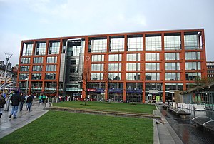
One Piccadilly Gardens
Office in Manchester, England
Distance: Approx. 65 meters
Latitude and longitude: 53.480512,-2.236168
One Piccadilly Gardens is a large office building in Manchester, England. It is located on the east side of Piccadilly Gardens, a large public square in Manchester city centre, and was built in 2003 on former public land, as part of the redevelopment of the gardens.

Westminster House, Manchester
Building in Manchester, England
Distance: Approx. 157 meters
Latitude and longitude: 53.4796,-2.2364
Westminster House is a commercial building on the south east side of Portland Street, Manchester. As "County Hall", it was the headquarters of Greater Manchester County Council from its formation in April 1974 to its abolition in March 1986.
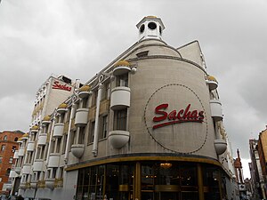
Sachas Hotel
Hotel in Manchester, England
Distance: Approx. 139 meters
Latitude and longitude: 53.4822,-2.2373
Sachas Hotel is a hotel in Manchester, England. The original building was built and opened as the C&A store in 1928, which later moved to a three-storey shop in the Arndale Centre in 1978. The building was converted into a hotel in 1987.
Weather in this IP's area
overcast clouds
17 Celsius
17 Celsius
16 Celsius
18 Celsius
1003 hPa
89 %
1003 hPa
997 hPa
10000 meters
2.06 m/s
200 degree
100 %
06:31:00
19:42:25