Country:
 USA
USARegion:
City:
Latitude and Longitude:
Time Zone:
Postal Code:
IP information under different IP Channel
ip-api
Country
Region
City
ASN
Time Zone
ISP
Blacklist
Proxy
Latitude
Longitude
Postal
Route
IPinfo
Country
Region
City
ASN
Time Zone
ISP
Blacklist
Proxy
Latitude
Longitude
Postal
Route
MaxMind
Country
Region
City
ASN
Time Zone
ISP
Blacklist
Proxy
Latitude
Longitude
Postal
Route
Luminati
Country
USRegion
ct
City
bridgeport
ASN
Time Zone
America/New_York
ISP
iNES GROUP SRL
Latitude
Longitude
Postal
db-ip
Country
Region
City
ASN
Time Zone
ISP
Blacklist
Proxy
Latitude
Longitude
Postal
Route
ipdata
Country
Region
City
ASN
Time Zone
ISP
Blacklist
Proxy
Latitude
Longitude
Postal
Route
Popular places and events near this IP address

Bridgeport station (Connecticut)
Railroad station in Bridgeport, Connecticut, US
Distance: Approx. 134 meters
Latitude and longitude: 41.1778,-73.1871
Bridgeport station is a shared Amtrak and Metro-North Railroad train station along the Northeast Corridor serving Bridgeport, Connecticut and nearby towns. On Metro-North, the station is the transfer point between the Waterbury Branch and the main New Haven Line. Amtrak's inter-city Northeast Regional and Vermonter service also stop at the station.

Barnum Museum
History Museum in Connecticut, U.S.
Distance: Approx. 429 meters
Latitude and longitude: 41.17527778,-73.18861111
The Barnum Museum is a museum at 820 Main Street in Bridgeport, Connecticut, United States. It has an extensive collection related to P. T. Barnum and the history of Bridgeport, and is housed in a historic building on the National Register of Historic Places. The building and its exhibits are connected to a portion of Bridgeport Center, a complex of buildings completed in 1989 on the same grounds as the Barnum Museum.

United States Post Office–Bridgeport Main
United States historic place
Distance: Approx. 345 meters
Latitude and longitude: 41.18055556,-73.18888889
The Bridgeport Main Post Office is located at 120 Middle Street in Bridgeport, Connecticut. It is a three-story Moderne/Art Deco, designed by Louis A. Simon, the supervising architect of the United States Treasury Department, and completed in 1934. The building notably includes artwork funded by the department's Section of Painting and Sculpture, with murals in its lobby area drawn by R. L. Lambden depicting mail delivery through the ages.

Bridgeport Downtown North Historic District
Historic district in Connecticut, United States
Distance: Approx. 424 meters
Latitude and longitude: 41.18027778,-73.19027778
The Bridgeport Downtown North Historic District encompasses a portion of the commercial downtown of Bridgeport, Connecticut. It is roughly bounded on the north by Congress Street, the east by Water and Middle Streets, the south by Fairfield Avenue, and the west by Lyon Terrace (although it does not include any properties on the latter street), roughly the northeastern quadrant of the downtown area. It is one of two large clusters of historically significant commercial and civic buildings (the other is the Bridgeport Downtown South Historic District) encapsulating the city's growth as an urban industrial and regional government center.

Hotel Beach
Historic hotel in Bridgeport, Connecticut
Distance: Approx. 405 meters
Latitude and longitude: 41.17916667,-73.19055556
The Hotel Beach, also known historically as the Hotel Barnum, is a historic hotel building at 140 Fairfield Ave. in Bridgeport, Connecticut. It is a thirteen-story Art Deco tower built in 1927 and designed by Thomas, Martin & Kirkpatrick.

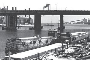
Berkshire No. 7
Wood and steel barge constructed in 1935
Distance: Approx. 121 meters
Latitude and longitude: 41.17833333,-73.18722222
Berkshire No. 7 is a wood and steel barge constructed in 1935. It is historically important as a transitional canal barge and as one of the few surviving wooden-hulled canal boats.
Elmer S. Dailey
Wooden barge by Willian H. Follette
Distance: Approx. 121 meters
Latitude and longitude: 41.17833333,-73.18722222
Elmer S. Dailey, originally known as the Claire B. Follette, is a wooden barge built by William H. Follette in 1915 at Tonawanda, New York, and rebuilt and renamed in 1928 by Brown Drydock on Staten Island, New York. It was used to transport materials from New York, New Jersey and Connecticut. It is the only known surviving Erie Canal boat and is one of a few remaining wooden-hulled canal boats.
Priscilla Dailey
Canal boat on the National Register of Historic Places
Distance: Approx. 121 meters
Latitude and longitude: 41.17833333,-73.18722222
Priscilla Dailey, previously known as the Elizabeth E. Newell, is a wooden canal boat constructed in 1929 in Whitehall, New York. The barge was used to transport bulk cargo in New York, New Jersey, and Connecticut harbors. It sank in 1974 along with the Elmer S. Dailey and the Berkshire No.
P.T. Barnum Bridge
Highway bridge in Bridgeport, Connecticut
Distance: Approx. 127 meters
Latitude and longitude: 41.1774,-73.1854
The P.T. Barnum Bridge is a highway bridge carrying Interstate 95 and the Connecticut Turnpike over the Pequonnock River in Bridgeport, Connecticut. There have been two bridges in the area. The first one was a girder-and-floorbeam bridge that carried six lanes of traffic but had no shoulders.

Bridgeport Center
Office building complex in Bridgeport, Connecticut
Distance: Approx. 274 meters
Latitude and longitude: 41.1765,-73.1877
Bridgeport Center (also known as the People's Bank Building) is a continuous complex of low to mid-rise office buildings in downtown Bridgeport, Connecticut. The complex served as the headquarters of People's United Financial, now a subsidiary of M&T Bank. It is to serve as the regional headquarters of M&T Bank in New England.

Park City Plaza
Office building in Bridgeport, Connecticut
Distance: Approx. 369 meters
Latitude and longitude: 41.1786,-73.1902
Park City Plaza (also known as 10 Middle Street) is an office building in Bridgeport, Connecticut. The building serves as the headquarters of the Trefz Corporation and their subsidiary company, Trefz Properties. It was designed by architect Victor Bisharat and finished construction in 1973.

Sterling Block-Bishop Arcade
United States historic place
Distance: Approx. 355 meters
Latitude and longitude: 41.17805556,-73.19
The Sterling Block-Bishop Arcade is a historic commercial building at 993-1005 Main Street in downtown Bridgeport, Connecticut. Built in 1841 and expanded several times in the 19th century, it is one of the oldest of the city's commercial buildings. It was also the first indoor shopping mall in the state.
Weather in this IP's area
clear sky
9 Celsius
7 Celsius
6 Celsius
11 Celsius
1033 hPa
71 %
1033 hPa
1032 hPa
10000 meters
2.06 m/s
340 degree
07:09:09
18:05:44