Country:
 USA
USARegion:
City:
Latitude and Longitude:
Time Zone:
Postal Code:
IP information under different IP Channel
ip-api
Country
Region
City
ASN
Time Zone
ISP
Blacklist
Proxy
Latitude
Longitude
Postal
Route
IPinfo
Country
Region
City
ASN
Time Zone
ISP
Blacklist
Proxy
Latitude
Longitude
Postal
Route
MaxMind
Country
Region
City
ASN
Time Zone
ISP
Blacklist
Proxy
Latitude
Longitude
Postal
Route
Luminati
Country
 RO
RORegion
cl
City
seinoiu
ASN
Time Zone
Europe/Bucharest
ISP
iNES GROUP SRL
Latitude
Longitude
Postal
db-ip
Country
Region
City
ASN
Time Zone
ISP
Blacklist
Proxy
Latitude
Longitude
Postal
Route
ipdata
Country
Region
City
ASN
Time Zone
ISP
Blacklist
Proxy
Latitude
Longitude
Postal
Route
Popular places and events near this IP address

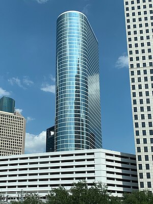
ExxonMobil Building
Skyscraper in Houston, Texas
Distance: Approx. 590 meters
Latitude and longitude: 29.7535,-95.3694
The ExxonMobil Building (also known as Exxon Tower, and formerly as Humble Oil Building) at 800 Bell Street in Houston, Texas is a 45-story, 1,200,000 sq ft (110,000 m2) skyscraper built in 1963, designed by Welton Becket & Associates. The building is known for its “fins” which protrude from the building’s exterior to provide shade from the sun. At the time of its construction, it was the tallest building west of the Mississippi River at 606 ft (185 m), surpassing the Republic Bank Tower in Dallas (the previous record holder).

Fourth Ward, Houston
Historic district in Houston, Texas, United States of America
Distance: Approx. 605 meters
Latitude and longitude: 29.756,-95.381
Fourth Ward is one of the historic six wards of Houston, Texas, United States. The Fourth Ward is located inside the 610 Loop directly west of and adjacent to Downtown Houston. The Fourth Ward is the site of Freedmen's Town, which was a post-U.S. Civil War community of African-Americans.

1600 Smith Street
Skyscraper in Houston, Texas
Distance: Approx. 332 meters
Latitude and longitude: 29.75518,-95.37275
1600 Smith Street (previously named Continental Center I and also known as Cullen Center Plaza) is a 51-story, 732-foot (223 m) office tower in Downtown Houston, Texas, United States. It served as the headquarters of Continental Airlines prior to its merger with United Airlines, and at one point also served as the headquarters of ExpressJet Airlines. It is a part of the Cullen Center complex.
1400 Smith Street
Skyscraper in Houston, Texas
Distance: Approx. 428 meters
Latitude and longitude: 29.75554,-95.37182
1400 Smith Street (formerly Enron Complex) is a 691 ft (211 m) tall skyscraper located in downtown Houston, Texas, United States. The building has 50 floors and is the 11th tallest building in the city. Designed by architectural firm Lloyd Jones Brewer and Associates, the building was completed in 1983.

1500 Louisiana Street
Skyscraper in Houston, Texas
Distance: Approx. 445 meters
Latitude and longitude: 29.7547,-95.37115
1500 Louisiana Street, formerly Enron Center South, is a 600 ft (183m) tall skyscraper in Houston, Texas. It was completed in 2002 and has 40 floors and a total building area of 1,284,013sq.ft. It is the 17th tallest building in the city and the tallest completed in the 2000s.

Wedge International Tower
Skyscraper located in Houston Texas
Distance: Approx. 572 meters
Latitude and longitude: 29.7548,-95.3698
Wedge International Tower, usually capitalized as WEDGE International Tower, is a skyscraper in Houston, Texas. The building was formerly known as the Southwest Bank of Texas Building, Unitedbank Plaza, and 1415 Louisiana. The building rises 551 feet (168 m) in height.

KBR Tower
Skyscraper in Houston, Texas, US
Distance: Approx. 309 meters
Latitude and longitude: 29.7533,-95.3723
KBR Tower (formerly the M. W. Kellogg Tower) is a 550 ft (167.6 m) tall skyscraper in Downtown Houston, Texas, United States; it is a part of the Cullen Center complex. The KBR Tower has the headquarters of KBR, Inc., an engineering, procurement, and construction company. The 40 story building has about 1,047,748 square feet (97,339.0 m2) of rentable office space.

West End Park (Houston)
Former baseball park in Houston, Texas
Distance: Approx. 199 meters
Latitude and longitude: 29.75493,-95.37443
West End Park was a baseball park in Houston from 1905 to the 1940s. It was the primary ballpark for the city when it was constructed, and the city's first venue for Negro Major League games. From 1909 through 1910 and again in 1915, it also served as the spring training facility of the St.

Cullen Center
Building complex in Houston, Texas, U.S.
Distance: Approx. 246 meters
Latitude and longitude: 29.753,-95.373
Cullen Center is a skyscraper complex in Downtown Houston, Texas, United States. The complex is now managed by Brookfield Properties. Previously Trizec Properties owned all four office buildings.

Bethel Baptist Church (Houston, Texas)
Historic church in Texas, United States
Distance: Approx. 252 meters
Latitude and longitude: 29.755613,-95.376035
Bethel Baptist Church is a historic Baptist church building at 801 Andrews in the Fourth Ward, Houston, Texas. The Late Gothic Revival building was constructed in 1923 and added to the National Register of Historic Places in 1998.

Beaconsfield (Houston)
Historic building in Houston, Texas, U.S.
Distance: Approx. 376 meters
Latitude and longitude: 29.75555556,-95.3725
The Beaconsfield is an apartment building located on Main Street at Pease Street in Downtown Houston. The building is listed on the National Register of Historic Places. The Beaconsfield was designed as an apartment building by local architect Alonzo C. Pigg.
Brazos River Bottom
Distance: Approx. 525 meters
Latitude and longitude: 29.74914,-95.377831
Brazos River Bottom, also known as the BRB, was a gay bar located in the Midtown, Houston, Texas, United States, that opened in 1978. At the time of its closure in 2013, it was one of Houston's oldest gay bars, and the oldest still running at its original location.
Weather in this IP's area
clear sky
24 Celsius
25 Celsius
22 Celsius
26 Celsius
1013 hPa
69 %
1013 hPa
1011 hPa
10000 meters
1.18 m/s
2.27 m/s
117 degree
3 %
07:19:00
18:58:28