Country:
Region:
City:
Latitude and Longitude:
Time Zone:
Postal Code:
IP information under different IP Channel
ip-api
Country
Region
City
ASN
Time Zone
ISP
Blacklist
Proxy
Latitude
Longitude
Postal
Route
Luminati
Country
Region
is
City
iasi
ASN
Time Zone
Europe/Bucharest
ISP
Orange Romania S.A.
Latitude
Longitude
Postal
IPinfo
Country
Region
City
ASN
Time Zone
ISP
Blacklist
Proxy
Latitude
Longitude
Postal
Route
db-ip
Country
Region
City
ASN
Time Zone
ISP
Blacklist
Proxy
Latitude
Longitude
Postal
Route
ipdata
Country
Region
City
ASN
Time Zone
ISP
Blacklist
Proxy
Latitude
Longitude
Postal
Route
Popular places and events near this IP address

Pitești
Municipality in Argeș, Romania
Distance: Approx. 1325 meters
Latitude and longitude: 44.86055556,24.86777778
Pitești (Romanian pronunciation: [piˈteʃtʲ] ) is a city in Romania, located on the river Argeș. The capital and largest city of Argeș County, it is an important commercial and industrial center, as well as the home of two universities. Pitești is situated in the historical region of Muntenia.

Râul Doamnei
River in Argeș County, Romania
Distance: Approx. 2397 meters
Latitude and longitude: 44.8625,24.8863
Râul Doamnei is a left tributary of the river Argeș in Romania. Its source is on the eastern slope of Moldoveanu Peak (Făgăraș Mountains), the highest mountain peak in Romania. It discharges into the Argeș just north of Pitești.
Pitești Prison
Former prison in Romania
Distance: Approx. 1739 meters
Latitude and longitude: 44.8648791,24.8638569
Pitești Prison (Romanian: Închisoarea Pitești) was a penal facility in Pitești, Romania, best remembered for the reeducation experiment (also known as Experimentul Pitești – the "Pitești Experiment" or Fenomenul Pitești – the "Pitești Phenomenon") which was carried out between December 1949 and September 1951, during Communist party rule. The experiment, which was implemented by a group of prisoners under the guidance of the prison administration, was designed as an attempt to violently "reeducate" the mostly young political prisoners, who were primarily supporters of the fascist Iron Guard, as well as Zionist members of the Romanian Jewish community. The Romanian People's Republic adhered to a doctrine of state atheism and the inmates who were held at Pitești Prison included religious believers, such as Christian seminarians.
Ion Brătianu National College (Pitești)
High school in Pitești, Argeș County, Romania
Distance: Approx. 1025 meters
Latitude and longitude: 44.8575,24.8682
The "Ion C. Brătianu" National College (Romanian: Colegiul Național Ion C. Brătianu) is a comprehensive four-year public high school with 1,200 students enrolled in grades 9 through 12, located at 14 Armand Călinescu Street, Pitești, Romania. It is named after the Romanian politician Ion C. Brătianu.
Palas Power Station
Distance: Approx. 1337 meters
Latitude and longitude: 44.86,24.87
The Palas Power Station is a large thermal power plant located in Constanța, Constanța County, Romania, having 2 generation groups of 50 MW each having a total electricity generation capacity of 100 MW.
Pitești Sud Power Station
Thermal power plant in Piteşti, Romania
Distance: Approx. 1063 meters
Latitude and longitude: 44.85833333,24.86666667
The Piteşti Sud Power Station is a large thermal power plant located in Piteşti, having 2 generation groups of 50 MW each and 3 groups of 12 MW having a total electricity generation capacity of 136 MW.
University of Pitești
University in Pitești, Romania
Distance: Approx. 2279 meters
Latitude and longitude: 44.86972222,24.86027778
The University of Piteşti (Romanian: Universitatea din Pitești, abbreviated UPIT) is a public university in Piteşti, Romania, founded in 1991.
Constantin Brâncoveanu University
Private university in Bucharest, Romania, founded in 1991
Distance: Approx. 2309 meters
Latitude and longitude: 44.869968,24.859868
The Constantin Brâncoveanu University is a private university in Pitești, Romania, founded in 1991.

Argeș County Museum
Distance: Approx. 947 meters
Latitude and longitude: 44.8553,24.8708
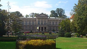
The Argeș County Museum (Romanian: Muzeul Județean Argeș) is a government institution and visitor attraction based in Pitești, Romania. Formally inaugurated in 1955, it is headquartered in an 1890s palace in the city center. Topics of its permanent exhibits include history, ecology, folk art and minerals.

Armenian Church, Pitești
Apostolic church in Pitești, Romania
Distance: Approx. 1212 meters
Latitude and longitude: 44.8529,24.8768
The Armenian Church (Romanian: Biserica Armenească) is an Armenian Apostolic church located at 43 Egalității Street in Pitești, Romania. It is dedicated to John the Baptist. Built in 1852, the church is trefoil in shape, with a hexagonal spire.

Zinca Golescu National College
School in Pitești, Romania
Distance: Approx. 1078 meters
Latitude and longitude: 44.85362,24.87452
The Zinca Golescu National College (Romanian: Colegiul Național "Zinca Golescu") is a public day high school located at 34 Egalității Street, Pitești, Romania. Founded as a girls' school in 1921, it initially had three grades, but expanded to eight grades from the 1924–1925 year. The school building dates to 1925–1928, and is classified as a historic monument by Romania's Ministry of Culture and Religious Affairs.
Trivale Monastery
Monastery in Pitești, Romania
Distance: Approx. 1164 meters
Latitude and longitude: 44.853,24.8485
The Trivale Monastery (Romanian: Mănăstirea Trivale) is a monastery located in Trivale Park,Pitești, România. The monastery is thought to have been established in the 16th century, although the exact date remains uncertain.Legend has it that the monastery temporarily housed the head of Michael the Brave (1593-1601) before it was transferred to Dealu Monastery. It is known that Doamna Stanca owned numerous properties around Pitești, so the hypothesis of her presence here is plausible.
Weather in this IP's area
light rain
10 Celsius
8 Celsius
10 Celsius
10 Celsius
1004 hPa
48 %
1004 hPa
966 hPa
10000 meters
1.36 m/s
2.24 m/s
238 degree
81 %
07:24:53
16:47:55
