Country:
 Romania
Region:
City:
Latitude and Longitude:
Time Zone:
Postal Code:
IP information under different IP Channel
ip-api
Country
Region
City
ASN
Time Zone
ISP
Blacklist
Proxy
Latitude
Longitude
Postal
Route
IPinfo
Country
Region
City
ASN
Time Zone
ISP
Blacklist
Proxy
Latitude
Longitude
Postal
Route
MaxMind
Country
Region
City
ASN
Time Zone
ISP
Blacklist
Proxy
Latitude
Longitude
Postal
Route
Luminati
Country
RORegion
vn
City
adjud
ASN
Time Zone
Europe/Bucharest
ISP
Orange Romania S.A.
Latitude
Longitude
Postal
db-ip
Country
Region
City
ASN
Time Zone
ISP
Blacklist
Proxy
Latitude
Longitude
Postal
Route
ipdata
Country
Region
City
ASN
Time Zone
ISP
Blacklist
Proxy
Latitude
Longitude
Postal
Route
Popular places and events near this IP address
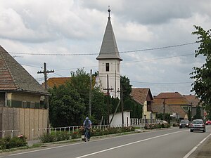
Ungheni, Mureș
Town in Mureș, Romania
Distance: Approx. 2240 meters
Latitude and longitude: 46.48583333,24.46083333
Ungheni (Hungarian: Nyárádtő [ˈɲaːraːttøː]; ‹See Tfd›German: Nyaradfluß) is a town in Mureș County, in Transylvania, Romania. Until 1925 its Romanian name was Nirașteu. Six villages are administered by the town: Cerghid (Nagycserged), Cerghizel (Kiscserged), Morești (Malomfalva), Recea (Recsa), Șăușa (Sóspatak), and Vidrasău (Vidrátszeg).

Transylvanian Plateau
Plateau in Romania
Distance: Approx. 1163 meters
Latitude and longitude: 46.5,24.5
The Transylvanian Plateau (Romanian: Podișul Transilvaniei; Hungarian: Erdélyi-medence) is a plateau in central Romania.

Cristești, Mureș
Commune in Mureș, Romania
Distance: Approx. 453 meters
Latitude and longitude: 46.5,24.48333333
Cristești (Hungarian: Maroskeresztúr, Hungarian pronunciation: [mɒroʃkɛrstuːr]) is a commune in Mureș County, Transylvania, Romania that is composed of two villages:

Gheorghe Doja, Mureș
Commune in Mureș, Romania
Distance: Approx. 3474 meters
Latitude and longitude: 46.46666667,24.5
Gheorghe Doja (Hungarian: Lukafalva, Hungarian pronunciation: [ˈlukɒfɒlvɒ]) is a commune in Mureș County, Transylvania, Romania composed of five villages: Gheorghe Doja, Ilieni (Lukailencfalva), Leordeni (Lőrincfalva), Satu Nou (Teremiújfalu), and Tirimia (Nagyteremi).

Pănet
Commune in Mureș, Romania
Distance: Approx. 6155 meters
Latitude and longitude: 46.55,24.46666667
Pănet (Hungarian: Mezőpanit, Hungarian pronunciation: [mɛzøːpɒnit]) is a commune in Mureș County, Transylvania, Romania composed of five villages:

Sângeorgiu de Mureș
Commune in Mureș, Romania
Distance: Approx. 6155 meters
Latitude and longitude: 46.55,24.46666667
Sângeorgiu de Mureș (Hungarian: Marosszentgyörgy [ˈmɒroʃsɛɲɟørɟ]) is a commune in Mureș County, Transylvania, Romania composed of three villages: Cotuș (Csejd), Sângeorgiu de Mureș, and Tofalău (Tófalva).
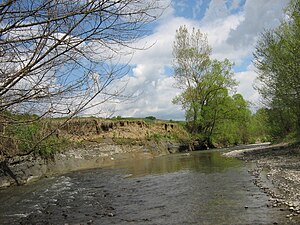
Niraj
River in Mureș County, Romania
Distance: Approx. 4818 meters
Latitude and longitude: 46.481,24.427
The Niraj (Hungarian: Nyárád; ‹See Tfd›German: Niersch) is a river in the Gurghiu Mountains, Mureș County, northern Romania. Its name originates from the Hungarian word nyár, meaning "poplar". It is a left tributary of the river Mureș.
Cerghid
River in Mureș County, Romania
Distance: Approx. 3853 meters
Latitude and longitude: 46.4786,24.4426
The Cerghid (Hungarian: Cserked, Cserked-patak) is a left tributary of the river Niraj in Transylvania, Romania. It joins the Niraj near Ungheni. Its length is 10 km (6.2 mi) and its basin size is 28 km2 (11 sq mi).
Cuieșd (river)
River in Mureș County, Romania
Distance: Approx. 2029 meters
Latitude and longitude: 46.5121,24.4726
The Cuieșd (Hungarian: Mezőkövesdi-patak) is a right tributary of the river Mureș in Transylvania, Romania. It discharges into the Mureș in Cristești. Its length is 13 km (8.1 mi) and its basin size is 56 km2 (22 sq mi).
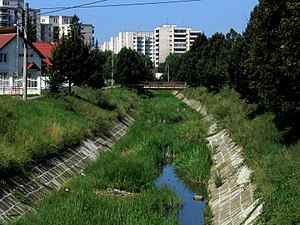
Pocloș
River in Mureș County, Romania
Distance: Approx. 6062 meters
Latitude and longitude: 46.5421,24.5286
The Pocloș ( Hungarian: Poklos, Poklos-patak ) is a left tributary of the river Mureș in Transylvania, Romania. It discharges into the Mureș in Târgu Mureș. Its length is 13 km (8.1 mi) and its basin size is 61 km2 (24 sq mi).

Castra of Cristești
Fort in the Roman province of Dacia
Distance: Approx. 1574 meters
Latitude and longitude: 46.51027778,24.48888889
Although not unanimously accepted, the existence of the castra of Cristești in the Roman province of Dacia is substantiated by bricks and tiles bearing the name of a Roman military unit, the Ala I Gallorum et Bosporanorum. The lack of any other traces of the Roman fort may easily be due to its destruction by the Mureș River. At Cristeşti, a Roman settlement from the 2nd and 3rd centuries AD was unearthed which was an important center of potters.
Târgu Mureș metropolitan area
Metropolitan area in Mureș, Romania
Distance: Approx. 6417 meters
Latitude and longitude: 46.53333333,24.55
The Târgu Mureș metropolitan area is a metropolitan area in Târgu Mureș, Romania. It was founded in 2005. It has a population of 209,532 as of the 2011 census.
Weather in this IP's area
broken clouds
14 Celsius
14 Celsius
14 Celsius
14 Celsius
1012 hPa
94 %
1012 hPa
977 hPa
10000 meters
75 %
07:26:01
18:54:32