Country:
Region:
City:
Latitude and Longitude:
Time Zone:
Postal Code:
IP information under different IP Channel
ip-api
Country
Region
City
ASN
Time Zone
ISP
Blacklist
Proxy
Latitude
Longitude
Postal
Route
Luminati
Country
Region
ph
City
ploiesti
ASN
Time Zone
Europe/Bucharest
ISP
Orange Romania S.A.
Latitude
Longitude
Postal
IPinfo
Country
Region
City
ASN
Time Zone
ISP
Blacklist
Proxy
Latitude
Longitude
Postal
Route
db-ip
Country
Region
City
ASN
Time Zone
ISP
Blacklist
Proxy
Latitude
Longitude
Postal
Route
ipdata
Country
Region
City
ASN
Time Zone
ISP
Blacklist
Proxy
Latitude
Longitude
Postal
Route
Popular places and events near this IP address

Administrative Palace, Satu Mare
Building in Romania
Distance: Approx. 2002 meters
Latitude and longitude: 47.78884,22.87308
The Administrative Palace (Romanian: Palatul administrativ) is a building in Satu Mare, Romania. At 97 metres, it is the highest building in Transylvania and one of the highest in the country. It is an example of brutalist style architecture.

Roman Catholic Diocese of Satu Mare
Roman Catholic diocese in Romania
Distance: Approx. 1818 meters
Latitude and longitude: 47.7928,22.8761
The Diocese of Satu Mare (Latin: Dioecesis Satmariensis; Hungarian: Szatmári Római Katolikus Püspökség) is a Latin diocese of the Catholic Church in Romania. It was established on 23 March 1804 by Francis I, King of Hungary, an act recognised by Pope Pius VII that 9 August. At the time, the diocese was part of the Kingdom of Hungary and covered a larger territory, including land in present-day Hungary and Slovakia as well as Romania.
Firemen's Tower (Satu Mare)
Distance: Approx. 1692 meters
Latitude and longitude: 47.794373,22.87587
Firemen's Tower (Romanian: Turnul Pompierilor, Hungarian: Tűzoltótorony) is a 47 m high tower in Satu Mare, Romania built in 1904 at the recommendation of bishop Gyula Meszlényi. The architect of the tower was Ferencz Dittler and the builder Lajos Vajnay. The tower was used, because of its height, as a fire spotter by the firemen.
Satu Mare Chain Church
Distance: Approx. 1585 meters
Latitude and longitude: 47.79533,22.87515
The Chains Church (Romanian: Biserica cu lanțuri; Hungarian: Láncos-templom), a Reformed church in Satu Mare, Romania, is one of the oldest churches in the city. Located on Păcii Square, it was built based on the plans of Preinlich Sigismund, an engineer, between 1793 and 1802. The church has a valuable collection of plates, disks and glasses dating from 1657 to 1679, as well as the oldest bell in Satu Mare, dating to 1633.
Calvaria Roman Catholic Church, Satu Mare
Building in Satu Mare, Romania
Distance: Approx. 1984 meters
Latitude and longitude: 47.7903,22.8755
The Calvaria Church (Romanian: Biserica Calvaria; Hungarian: Kálvária templom) is a Roman Catholic religious building in Satu Mare, Romania, and one of the oldest churches in the city. Located on Mihai Eminescu Street, it was originally built in 1844, and stands in place of the old fortress Castrum-Zothmar. Its original walls broke after the foundation caved over the sandy ground.
UNIO High School
School in Satu Mare, Satu Mare County, Romania
Distance: Approx. 1975 meters
Latitude and longitude: 47.79125,22.87682
"UNIO" High School (Romanian: Grupul Școlar Industrial Construcții de Mașini "UNIO") is a public day high school for students aged 14 to 18, established in 1948 and located at 1 Mihai Eminescu Street, Satu Mare, Romania. The school is named after a local company, UNIO Satu Mare, specialised in producing equipment for the mining, transport, and energy industries.

Satu Mare Synagogue
Neolog synagogue in Satu Mare, Romania
Distance: Approx. 1893 meters
Latitude and longitude: 47.7908,22.8745
The Satu Mare Synagogue (Romanian: Templul Mare din Satu Mare), also known as the Decebal Street Synagogue, is a Neolog Jewish congregation and synagogue, located at 4 Decebal Street, in Satu Mare, Transylvania, Romania. The synagogue is included on the National Register of Historic Monuments in Romania. Designed in the Moorish Revival style, the synagogue was completed in 1870.
Ioan Slavici National College
School in Satu Mare, Satu Mare County, Romania
Distance: Approx. 1490 meters
Latitude and longitude: 47.7973,22.8755
Ioan Slavici National College (Romanian: Colegiul Național Ioan Slavici) is a public day high school for students aged 10 to 18, established in 1812, and located at 4 Ioan Slavici Street, Satu Mare, Romania. The school is named after the great Romanian writer and journalist Ioan Slavici. The Ioan Slavici National College is one of the four national colleges located in Satu Mare, alongside Mihai Eminescu, Kölcsey Ferenc, and Doamna Stanca.
Kölcsey Ferenc National College
School in Satu Mare, Satu Mare County, Romania
Distance: Approx. 1939 meters
Latitude and longitude: 47.8,22.88333333
Kölcsey Ferenc National College (Romanian: Colegiul Național Kölcsey Ferenc, Hungarian: Kölcsey Ferenc Főgimnázium) is a public day high school for students aged 10 to 18, established in 1557 as a reformed school, and located at 2 George Coșbuc Street, Satu Mare, Romania. The school is named after the great Hungarian poet, literary critic, orator, and politician Ferenc Kölcsey. The Kölcsey Ferenc National College is one of the only four national colleges located in Satu Mare alongside Mihai Eminescu, Ioan Slavici, and Doamna Stanca.
Doamna Stanca National College (Satu Mare)
School in Satu Mare, Romania
Distance: Approx. 1559 meters
Latitude and longitude: 47.79479,22.87408
Doamna Stanca National College (Romanian: Colegiul Național Doamna Stanca) is a public day high school for students aged 10 to 18, established in 1816, and located in Satu Mare, Romania. The school is named after the spouse of the Romanian ruler Michael the Brave. The Doamna Stanca National College is one of four national colleges located in Satu Mare, alongside Mihai Eminescu, Ioan Slavici, and Kölcsey Ferenc.
North Theatre (Satu Mare)
Theatre in Satu Mare, Romania
Distance: Approx. 1792 meters
Latitude and longitude: 47.794128,22.877274
The North Theatre (Romanian: Teatrul de Nord) is a theatre in Satu Mare, Romania.

Ascension Cathedral, Satu Mare
Church in Satu Mare, Romania
Distance: Approx. 1855 meters
Latitude and longitude: 47.7926,22.8765
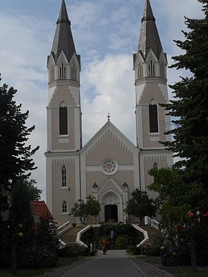
The Ascension Cathedral (Romanian: Catedrala romano-catolică Înălțarea Domnului; in Hungarian commonly Nagytemplom, Great Church) is the name given to a religious building belonging to the Catholic Church that serves as the cathedral church of the diocese of Satu Mare. It is located in the city of Satu Mare, in the northern part of Romania. The Satu Mare cathedral was built between 1830 and 1837 according to plans by József Hild, using parts of the former baroque cathedral (built in 1786).
Weather in this IP's area
moderate rain
10 Celsius
7 Celsius
9 Celsius
10 Celsius
994 hPa
82 %
994 hPa
979 hPa
10000 meters
5.66 m/s
200 degree
75 %
07:42:09
16:46:41


