89.117.35.112 - IP Lookup: Free IP Address Lookup, Postal Code Lookup, IP Location Lookup, IP ASN, Public IP
Country:
Region:
City:
Location:
Time Zone:
Postal Code:
IP information under different IP Channel
ip-api
Country
Region
City
ASN
Time Zone
ISP
Blacklist
Proxy
Latitude
Longitude
Postal
Route
Luminati
Country
ASN
Time Zone
Europe/Vilnius
ISP
WIIT AG
Latitude
Longitude
Postal
IPinfo
Country
Region
City
ASN
Time Zone
ISP
Blacklist
Proxy
Latitude
Longitude
Postal
Route
IP2Location
89.117.35.112Country
Region
-
City
-
Time Zone
ISP
Language
User-Agent
Latitude
Longitude
Postal
db-ip
Country
Region
City
ASN
Time Zone
ISP
Blacklist
Proxy
Latitude
Longitude
Postal
Route
ipdata
Country
Region
City
ASN
Time Zone
ISP
Blacklist
Proxy
Latitude
Longitude
Postal
Route
Popular places and events near this IP address

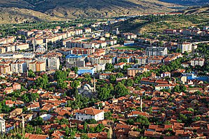
Çankırı
Municipality in Turkey
Distance: Approx. 357 meters
Latitude and longitude: 40.59861111,33.61916667
Çankırı, historically known as Gangra (Greek: Γάγγρα), is a city in Turkey, about 140 km (87 mi) northeast of Ankara. It is situated about 800 m (2500 ft) above sea level. It is the seat of Çankırı Province and of Çankırı District.

Çankırı Karatekin University
Public university in Çankırı, Turkey
Distance: Approx. 796 meters
Latitude and longitude: 40.5959,33.6075
Çankırı Karatekin University (Turkish: Çankırı Karatekin Üniversitesi) is a university located in Çankırı, Turkey. It was established in 2007.
Kobara
Town of ancient Paphlagonia
Distance: Approx. 4130 meters
Latitude and longitude: 40.56645,33.63644
Kobara was a town of ancient Paphlagonia, inhabited in Byzantine times. The name does not occur among ancient authors but is inferred from epigraphic and other evidence. Its site is located near Doğantepe, Asiatic Turkey.
Aşağıyanlar, Çankırı
Village in Turkey
Distance: Approx. 6911 meters
Latitude and longitude: 40.55,33.56666667
Aşağıyanlar is a village in the Çankırı District of Çankırı Province in Turkey. Its population is 257 (2021).
Ayan, Çankırı
Village in Turkey
Distance: Approx. 8052 meters
Latitude and longitude: 40.671,33.5978
Ayan is a village in the Çankırı District of Çankırı Province in Turkey. Its population is 157 (2021).
Doğantepe, Çankırı
Village in Turkey
Distance: Approx. 6954 meters
Latitude and longitude: 40.544,33.652
Doğantepe is a village in the Çankırı District of Çankırı Province in Turkey. Its population is 310 (2021).
Hıdırlık, Çankırı
Village in Turkey
Distance: Approx. 3189 meters
Latitude and longitude: 40.59694444,33.57777778
Hıdırlık is a village in the Çankırı District of Çankırı Province in Turkey. Its population is 37 (2021).
İçyenice, Çankırı
Village in Turkey
Distance: Approx. 6197 meters
Latitude and longitude: 40.65,33.58333333
İçyenice is a village in the Çankırı District of Çankırı Province in Turkey. Its population is 179 (2021).
İnaç, Çankırı
Village in Turkey
Distance: Approx. 7545 meters
Latitude and longitude: 40.6303,33.6951
İnaç is a village in the Çankırı District of Çankırı Province in Turkey. Its population is 187 (2021).
Tuzlu, Çankırı
Village in Turkey
Distance: Approx. 5520 meters
Latitude and longitude: 40.62305556,33.67305556
Tuzlu is a village in the Çankırı District of Çankırı Province in Turkey. Its population is 182 (2021).
Yukarıyanlar, Eldivan
Village in Turkey
Distance: Approx. 7792 meters
Latitude and longitude: 40.57444444,33.52944444
Yukarıyanlar is a village in the Eldivan District of Çankırı Province in Turkey. Its population is 105 (2021).

Çankırı District
District of Çankırı Province, Turkey
Distance: Approx. 116 meters
Latitude and longitude: 40.6,33.61666667
Çankırı District (also: Merkez, meaning "central") is a district of the Çankırı Province of Turkey. Its seat is the city of Çankırı. Its area is 1,440 km2, and its population is 100,027 (2021).
Weather in this IP's area
overcast clouds
5 Celsius
5 Celsius
5 Celsius
5 Celsius
1018 hPa
72 %
1018 hPa
901 hPa
10000 meters
0.54 m/s
1.16 m/s
150 degree
100 %