Country:
 France
Region:
City:
Latitude and Longitude:
Time Zone:
Postal Code:
IP information under different IP Channel
ip-api
Country
Region
City
ASN
Time Zone
ISP
Blacklist
Proxy
Latitude
Longitude
Postal
Route
IPinfo
Country
Region
City
ASN
Time Zone
ISP
Blacklist
Proxy
Latitude
Longitude
Postal
Route
MaxMind
Country
Region
City
ASN
Time Zone
ISP
Blacklist
Proxy
Latitude
Longitude
Postal
Route
Luminati
Country
FRASN
Time Zone
Europe/Paris
ISP
Accenture SAS
Latitude
Longitude
Postal
db-ip
Country
Region
City
ASN
Time Zone
ISP
Blacklist
Proxy
Latitude
Longitude
Postal
Route
ipdata
Country
Region
City
ASN
Time Zone
ISP
Blacklist
Proxy
Latitude
Longitude
Postal
Route
Popular places and events near this IP address

Stade de France
Stadium in Saint-Denis, Paris, France
Distance: Approx. 935 meters
Latitude and longitude: 48.92444444,2.36
Stade de France (French pronunciation: [stad də fʁɑ̃s], lit. 'Stadium of France') is the national stadium of France, located just north of Paris in the commune of Saint-Denis. Its seating capacity of 80,698 makes it the largest stadium in France. The stadium is used by the French national football and rugby union teams for international competitions.

Arrondissement of Saint-Denis, Seine-Saint-Denis
Arrondissement in Île-de-France, France
Distance: Approx. 1262 meters
Latitude and longitude: 48.93361111,2.35638889
The arrondissement of Saint-Denis (French: arrondissement de Saint-Denis) is an arrondissement (district) of France in the Seine-Saint-Denis department, Île-de-France. It has 9 communes. Its population is 443,169 (2019), and its area is 47.4 km2 (18.3 sq mi).

Tour Pleyel
Mixed use in Saint-Denis, France
Distance: Approx. 474 meters
Latitude and longitude: 48.92,2.345
Tour Pleyel is a skyscraper of mixed use, both residential and commercial, located in the commune of Saint-Denis in the suburbs of Paris, France. Built in 1972, the tower is 129 metres tall. At the top is a large turning advertising sign, in place since 1997 (the advertisement was firstly for Philips, then for Siemens from 2006 to 2013, and is currently for Kia Motors).
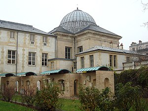
Musée d'art et d'histoire de Saint-Denis
Distance: Approx. 1134 meters
Latitude and longitude: 48.93222222,2.35638889
The Museum of Art and History (in French: Musée d'Art et d'Histoire Paul-Éluard), is a museum located in the historical town of Saint-Denis, France, in the northern outskirts of Paris.
École nationale supérieure Louis-Lumière
Postgraduate establishment serving the French audiovisual industry
Distance: Approx. 874 meters
Latitude and longitude: 48.9222,2.3356
The École nationale supérieure Louis-Lumière (ENS Louis-Lumière) offers theoretical, practical as well as technical and artistic education and training for those wishing to go into the various branches of the audiovisual industry in France. Run under the auspices of the Ministry of Higher Education, it offers a state-funded course at postgraduate level leading to a nationally recognised diploma equivalent to a Master's degree.

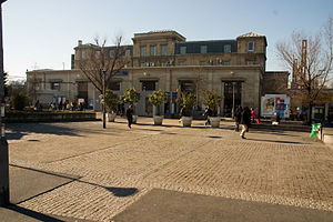
Carrefour Pleyel station
Metro station in Paris, France
Distance: Approx. 508 meters
Latitude and longitude: 48.92,2.34389
Carrefour Pleyel station (French pronunciation: [kaʁfuʁ plɛjɛl]) is a station on Line 13 of the Paris Métro in the Saint-Denis plain in the commune of Saint-Denis. It was opened in 1952.

Saint-Denis–Porte de Paris station
Metro station in Paris, France
Distance: Approx. 1041 meters
Latitude and longitude: 48.93028,2.35778
Saint-Denis–Porte de Paris (French pronunciation: [sɛ̃ dəni pɔʁt də paʁi]) is a station on Line 13 of the Paris Métro in the commune of Saint-Denis.
Saint-Denis station
French train stop
Distance: Approx. 728 meters
Latitude and longitude: 48.917816,2.350474
Saint-Denis station is a railway station serving Saint-Denis, a northern suburb of Paris in Seine-Saint-Denis department, France. It is on the lines from Paris-Nord to Pontoise, Beauvais and Creil. The station was the terminus of tramway T1 between 1992 and 2012 when the line was extended to Asnières–Gennevilliers–Les Courtilles.

Stade de France–Saint-Denis station
Railway station serving Saint-Denis, Paris, France
Distance: Approx. 734 meters
Latitude and longitude: 48.91777778,2.35055556
Stade de France–Saint-Denis is a railway station serving Saint-Denis, a northern suburb of Paris in Seine-Saint-Denis department, France. It is near the Stade de France, on the RER D suburban railway line. It is on the Paris–Lille railway.
Canton of Saint-Denis-1, Seine-Saint-Denis
Distance: Approx. 489 meters
Latitude and longitude: 48.92,2.35
The canton of Saint-Denis-1 is an administrative division of the Seine-Saint-Denis department, Île-de-France region, northern France. It was created at the French canton reorganisation which came into effect in March 2015. Its seat is in Saint-Denis.
Ensemble Scolaire Jean-Baptiste de La Salle - Notre-Dame de la Compassion
Public high school
Distance: Approx. 1134 meters
Latitude and longitude: 48.93285,2.3549
Ensemble Scolaire Jean-Baptiste de La Salle - Notre-Dame de la Compassion is a private Catholic school in Saint-Denis, Seine-Saint-Denis, France, in the Paris metropolitan area. It serves primary school through sixth-form college/senior high school (lycée). As of 2014 about 2,400 students attend this school.
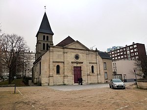
Church of Saint-Ouen-le-Vieux
Roman Catholic church in Saint-Ouen-sur-Seine, Seine-Saint-Denis, France
Distance: Approx. 1273 meters
Latitude and longitude: 48.91888889,2.33166667
The Church of Saint-Ouen-le-Vieux (French: église Saint-Ouen-le-Vieux) or the Church of Vieux-Saint-Ouen (église du Vieux-Saint-Ouen) is a Roman Catholic church dedicated to St. Ouen and located in Saint-Ouen-sur-Seine in the department of Seine-Saint-Denis, France. It was listed as a Historic Monument in 1933.
Weather in this IP's area
clear sky
19 Celsius
18 Celsius
17 Celsius
19 Celsius
1020 hPa
77 %
1020 hPa
1015 hPa
9000 meters
6.17 m/s
40 degree
07:33:15
19:55:28