89.104.248.96 - IP Lookup: Free IP Address Lookup, Postal Code Lookup, IP Location Lookup, IP ASN, Public IP
Country:
Region:
City:
Location:
Time Zone:
Postal Code:
ISP:
ASN:
language:
User-Agent:
Proxy IP:
Blacklist:
IP information under different IP Channel
ip-api
Country
Region
City
ASN
Time Zone
ISP
Blacklist
Proxy
Latitude
Longitude
Postal
Route
db-ip
Country
Region
City
ASN
Time Zone
ISP
Blacklist
Proxy
Latitude
Longitude
Postal
Route
IPinfo
Country
Region
City
ASN
Time Zone
ISP
Blacklist
Proxy
Latitude
Longitude
Postal
Route
IP2Location
89.104.248.96Country
Region
scotland
City
port elphinstone
Time Zone
Europe/London
ISP
Language
User-Agent
Latitude
Longitude
Postal
ipdata
Country
Region
City
ASN
Time Zone
ISP
Blacklist
Proxy
Latitude
Longitude
Postal
Route
Popular places and events near this IP address

Inverurie
Town in northeast Scotland
Distance: Approx. 1375 meters
Latitude and longitude: 57.28416667,-2.37472222
Inverurie (Scottish Gaelic: Inbhir Uraidh or Inbhir Uaraidh, 'mouth of the River Ury') is a town in Aberdeenshire, Scotland at the confluence of the rivers Ury and Don, about 16 miles (26 km) north-west of Aberdeen.

Aberdeenshire Canal
Defunct canal in Aberdeenshire, Scotland, UK
Distance: Approx. 416 meters
Latitude and longitude: 57.26831,-2.36973
The Aberdeenshire Canal was a waterway in Aberdeenshire, Scotland, designed by John Rennie, which ran from the port of Aberdeen to Port Elphinstone, Inverurie. It was originally planned to reach Monymusk, but had been truncated by the time an act of Parliament was obtained in 1796. Construction was hampered by a lack of finance, and some local opposition, but it opened in 1805.

Garioch
Distance: Approx. 1387 meters
Latitude and longitude: 57.284,-2.377
Garioch (Scots: The Geerie, GEER-ee, Scottish Gaelic: Gairbheach) is one of six committee areas in Aberdeenshire, Scotland. It has a population of 46,254 (2006 estimate), which gives it the largest population of Aberdeenshire's six committee areas. The Garioch consists primarily of the district drained by the River Ury and its tributaries the Shevock and the Gadie Burn.

Inverurie railway station
Railway station in Aberdeenshire, Scotland
Distance: Approx. 1646 meters
Latitude and longitude: 57.2867,-2.3737
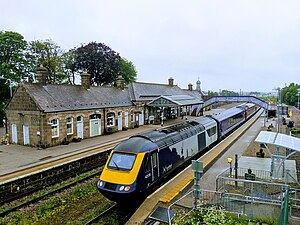
Inverurie railway station is a railway station serving the town of Inverurie, Aberdeenshire, Scotland. It is managed by ScotRail and is on the Aberdeen to Inverness Line, which is mostly single track north of this point, between Kintore and Insch. It is measured 16 miles 72 chains (27.2 kilometres) from Aberdeen.

Inverurie Hospital
Hospital in Aberdeenshire, Scotland
Distance: Approx. 727 meters
Latitude and longitude: 57.27722222,-2.37805556
Inverurie Hospital is a small hospital in Inverurie, Aberdeenshire, Scotland. It is managed by NHS Grampian.

Battle of Inverurie (1745)
Battle in Jacobite rising
Distance: Approx. 1195 meters
Latitude and longitude: 57.282,-2.378
The Battle of Inverurie was fought on 23 December 1745 at Inverurie, Aberdeenshire, Scotland, during the Jacobite rising of 1745.

Inverurie Locomotive Works
Distance: Approx. 1570 meters
Latitude and longitude: 57.286,-2.374
Inverurie Locomotive Works was created in 1902 when the Great North of Scotland Railway (GNSR) moved their works from Kittybrewster, in Aberdeen about 15 miles (24 km) to Inverurie.
Port Elphinstone railway station
Disused freight depot in Aberdeenshire, Scotland
Distance: Approx. 605 meters
Latitude and longitude: 57.268,-2.364
Port Elphinstone railway station was a freight depot in Port Elphinstone, Aberdeenshire.

Broomend of Crichie stone
Distance: Approx. 566 meters
Latitude and longitude: 57.2672,-2.3677
The Broomend of Crichie Stone is a class I Pictish stone that stands within a henge at Broomend of Crichie, Port Elphinstone, Inverurie, Aberdeenshire, Scotland. It was placed within the henge in the 19th century. The stone bears the incised symbols of the Pictish beast and the crescent and V-rod.

Caskieben
Scottish estate
Distance: Approx. 1533 meters
Latitude and longitude: 57.28203425,-2.35334179
Caskieben ( kahs-KEE-ben; Scottish Gaelic: Gasach beinn "Wooded Hill", later Keith Hall) was a palisaded tower built by the Garviach family during the 12th-century Norman expansion into Scotland. It stood on a low, circular mound surrounded by a 2 metre deep, 15 metre wide moat.

Inverurie Town Hall
Municipal building in Inverurie, Scotland
Distance: Approx. 1408 meters
Latitude and longitude: 57.2845,-2.3744
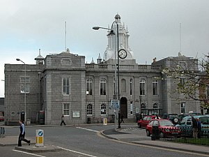
Inverurie Town Hall is a municipal building in the Market Place in Inverurie, Scotland. The structure, which served as the meeting place of Inverurie Burgh Council, is a Category B listed building.

Bass of Inverurie
Castle in Aberdeenshire, Scotland, UK
Distance: Approx. 523 meters
Latitude and longitude: 57.2755,-2.365
The Bass of Inverurie is the remnant of a motte-and-bailey castle based on a natural mound about 50 feet (15 m) high and 60 feet (18 m) in diameter to the south of the town of Inverurie in Aberdeenshire, Scotland. The Bass and the adjacent Little Bass to the east are the remains of the castle of Inverurie, the administrative centre of the provincial lordship of the Garioch in the 12th and 13th centuries.
Weather in this IP's area
overcast clouds
9 Celsius
8 Celsius
8 Celsius
9 Celsius
1026 hPa
80 %
1026 hPa
1010 hPa
10000 meters
2.57 m/s
160 degree
95 %