Country:
 Great Britain
Region:
City:
Latitude and Longitude:
Time Zone:
Postal Code:
IP information under different IP Channel
ip-api
Country
Region
City
ASN
Time Zone
ISP
Blacklist
Proxy
Latitude
Longitude
Postal
Route
IPinfo
Country
Region
City
ASN
Time Zone
ISP
Blacklist
Proxy
Latitude
Longitude
Postal
Route
MaxMind
Country
Region
City
ASN
Time Zone
ISP
Blacklist
Proxy
Latitude
Longitude
Postal
Route
Luminati
Country
GBRegion
eng
City
altrincham
ASN
Time Zone
Europe/London
ISP
Zen Internet Ltd
Latitude
Longitude
Postal
db-ip
Country
Region
City
ASN
Time Zone
ISP
Blacklist
Proxy
Latitude
Longitude
Postal
Route
ipdata
Country
Region
City
ASN
Time Zone
ISP
Blacklist
Proxy
Latitude
Longitude
Postal
Route
Popular places and events near this IP address
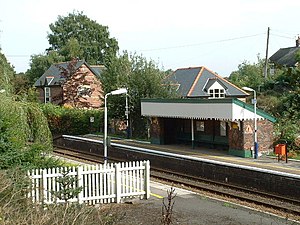
Ashley railway station
Railway station in Cheshire, England
Distance: Approx. 743 meters
Latitude and longitude: 53.356,-2.341
Ashley railway station is in the village of Ashley in Cheshire, England. It is located on the Mid-Cheshire line 17+3⁄4 miles (28.6 km) southwest of Manchester Piccadilly.

Hale Barns
Human settlement in England
Distance: Approx. 2210 meters
Latitude and longitude: 53.366,-2.313
Hale Barns is a village near Altrincham in Greater Manchester, England. It lies in the historic county of Cheshire, 7 miles (11 km) south-west of Manchester city centre, 2 miles west of Manchester Airport and close to the River Bollin. At the 2011 census, the village had a population of 9,736.

Ashley, Cheshire
Human settlement in England
Distance: Approx. 486 meters
Latitude and longitude: 53.354,-2.339
Ashley is a village and civil parish in Cheshire, England. At the 2001 census, it had a population of 261. The village is close to the border with Greater Manchester, just to the south of the M56 motorway and Manchester Airport.
Bucklow Rural District
Distance: Approx. 2257 meters
Latitude and longitude: 53.33333333,-2.31666667
Bucklow Rural District was, from 1894 to 1974, a local government district in the north of the administrative county of Cheshire, England. Following the Local Government Act 1972, this rural district was split between the new Greater Manchester boroughs of Trafford and Manchester, and Macclesfield, which was retained in Cheshire. Knutsford was an enclave and independent urban district surrounded by Bucklow RD, as was Altrincham until it expanded enough to link up with other districts in the north.

Mobberley railway station
Railway station in Cheshire, England
Distance: Approx. 2306 meters
Latitude and longitude: 53.33,-2.333
Mobberley railway station serves the village of Mobberley in Cheshire, England. It is to the north of the village and is managed by Northern Trains. The station is 18½ miles (30 km) south of Manchester Piccadilly on the Mid-Cheshire line towards Chester.

St Ambrose College
Christian brothers' grammar school in Hale Barns , Altrincham, Greater Manchester, England
Distance: Approx. 2408 meters
Latitude and longitude: 53.370533,-2.319741
St Ambrose College is an 11–18 Christian Brothers' Roman Catholic boys' grammar school in Hale Barns, Altrincham, Greater Manchester, England. It was founded in 1946 by Joseph Robertson. In 2012 the school became an academy, and was completely re-built.
Ullerwood Castle
Castle in Greater Manchester, England
Distance: Approx. 2240 meters
Latitude and longitude: 53.3504,-2.3005
Ullerwood Castle is an early medieval castle, possibly a shell keep, in Ringway, Manchester, England (grid reference SJ800838). The castle is first referred to in 1173, in a document stating Hamon de Masci held the castles of Ullerwood and Dunham. There is no other contemporary documented reference to the castle.

Royd House
Distance: Approx. 2900 meters
Latitude and longitude: 53.37638889,-2.32694444
Royd House is a Grade I listed building in Hale, Greater Manchester. It was designed by architect Edgar Wood as his own home and was built between 1914 and 1916. The building is regarded as one of the most advanced examples of early twentieth century domestic architecture.
Cotterill Clough Nature Reserve
Nature reserve in Manchester, England
Distance: Approx. 2865 meters
Latitude and longitude: 53.3501,-2.2911
Cotterill Clough is a 5.6-hectare (14-acre) nature reserve near Manchester Airport. It is managed by the Cheshire Wildlife Trust and lies within a larger Site of Special Scientific Interest (SSSI). The Cotterill Brook, which flows through the reserve, is a tributary of the River Bollin.

Ashley Hall, Cheshire
Historic site in Ashley, Cheshire
Distance: Approx. 1498 meters
Latitude and longitude: 53.36087,-2.34896
Ashley Hall is a country house standing to the north of the village of Ashley, Cheshire, England. It dates from the late 16th to the early 17th century, with additions made in the 18th and 19th centuries. The house is historically important because it was here that the Cheshire gentlemen met in 1715 to decide whether to support the Stuarts or the Hanoverians.

St Elizabeth's Church, Ashley
Church in Cheshire, England
Distance: Approx. 824 meters
Latitude and longitude: 53.3556,-2.3435
St Elizabeth's Church is on Ashley Road in the village of Ashley, Cheshire, England. It is an active Anglican parish church in the deanery of Bowdon, the archdeaconry of Macclesfield, and the diocese of Chester. Its benefice is combined with that of St Peter, Hale.
Warburton Green
Human settlement in England
Distance: Approx. 1912 meters
Latitude and longitude: 53.36,-2.31
Warburton Green is a district of Hale Barns, Greater Manchester. It is situated to the south east of the centre of the village, close to the M56 and River Bollin. The housing estate grew up around the original hamlet, which was formed by Tanyard Farm and neighbouring properties on Chapel Lane.
Weather in this IP's area
scattered clouds
14 Celsius
13 Celsius
13 Celsius
14 Celsius
1008 hPa
81 %
1008 hPa
1003 hPa
10000 meters
3.13 m/s
5.36 m/s
153 degree
40 %
07:42:01
18:06:30