88.97.134.108 - IP Lookup: Free IP Address Lookup, Postal Code Lookup, IP Location Lookup, IP ASN, Public IP
Country:
 Great Britain
Region:
City:
Location:
Time Zone:
Postal Code:
ISP:
ASN:
language:
User-Agent:
Proxy IP:
Blacklist:
IP information under different IP Channel
ip-api
Country
Region
City
ASN
Time Zone
ISP
Blacklist
Proxy
Latitude
Longitude
Postal
Route
db-ip
Country
Region
City
ASN
Time Zone
ISP
Blacklist
Proxy
Latitude
Longitude
Postal
Route
IPinfo
Country
Region
City
ASN
Time Zone
ISP
Blacklist
Proxy
Latitude
Longitude
Postal
Route
IP2Location
88.97.134.108Country
gbRegion
england
City
grayrigg
Time Zone
Europe/London
ISP
Language
User-Agent
Latitude
Longitude
Postal
ipdata
Country
Region
City
ASN
Time Zone
ISP
Blacklist
Proxy
Latitude
Longitude
Postal
Route
Popular places and events near this IP address

Grayrigg Forest
Hill in Cumbria, England
Distance: Approx. 3320 meters
Latitude and longitude: 54.39208,-2.6206
Grayrigg Forest is a hill in Cumbria, England, located on the eastern edge of what might be considered the Lake District. In August 2016 it became part of the eponymous national park. Reaching 494 metres (1,621 ft) above sea level, its summit is attainable from the less well-known Borrowdale valley.

Grayrigg
Human settlement in England
Distance: Approx. 123 meters
Latitude and longitude: 54.367,-2.65
Grayrigg is a small village and civil parish in the Westmorland and Furness district of Cumbria, England. In the 2001 census the parish had a population of 223, increasing at the 2011 census to 242. It lies on undulated and partly mountainous land, 4.9 miles (8 km) north east of Kendal, on the north side of the West Coast Main Line, and west side of the M6 motorway.

Docker, Cumbria
Human settlement in England
Distance: Approx. 1880 meters
Latitude and longitude: 54.354,-2.667
Docker is a civil parish in the Westmorland and Furness district of the English county of Cumbria. Docker is 4.3 miles north east of the market town of Kendal. At the 2011 census Docker was grouped with Lambrigg giving a total population of 260.
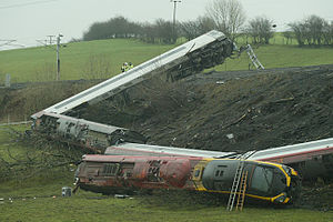
Grayrigg derailment
2007 rail transport disaster in Grayrigg, England
Distance: Approx. 1289 meters
Latitude and longitude: 54.3575,-2.65916667
The Grayrigg derailment was a fatal railway accident that occurred at approximately 20:15 GMT on 23 February 2007, just to the south of Grayrigg, Cumbria, in the North West England region of the United Kingdom. The accident investigation concluded that the derailment was caused by a faulty set of points (number 2B) on the Down Main running line, controlled from Lambrigg ground frame. The scheduled inspection on 18 February 2007 had not taken place and the faults had gone undetected.

Lambrigg Fell
339m high hill in England
Distance: Approx. 3139 meters
Latitude and longitude: 54.34076,-2.63828
Lambrigg Fell is a hill, the highest point of the area of high ground between Kendal and the M6, in south-eastern Cumbria, England. It lies just outside the area normally defined as the Lake District, and the hill is not in the same mould as the nearby Lakeland Fells, being a sprawling, grassy moorland. For this reason, it is not nearly as popular as its subsidiary top to the west, Benson Knott, which overlooks Kendal.

Beck Foot
Village in Cumbria, England
Distance: Approx. 3857 meters
Latitude and longitude: 54.35,-2.6
Beck Foot is a hamlet in Cumbria, England, situated on the B6257 road south of Lowgill, the West Coast Main Line and M6 motorway. The disused Lowgill Viaduct is close by.

Beck Houses
Village in Cumbria, England
Distance: Approx. 2123 meters
Latitude and longitude: 54.35,-2.64
Beck Houses is a hamlet in Cumbria, England. It lies south of Grayrigg in the Westmorland and Furness unitary authority area. The West Coast Main Line passes close by and provides a popular viewpoint for railway photographers.

Patton Bridge
Human settlement in England
Distance: Approx. 2100 meters
Latitude and longitude: 54.37,-2.683
Patton Bridge is a small rural hamlet approximately 5 miles from the outskirts of Kendal, Cumbria, England. Its post code region is LA8.

Lambrigg
Human settlement in England
Distance: Approx. 2319 meters
Latitude and longitude: 54.353,-2.626
Lambrigg is a civil parish in the Westmorland and Furness district of the English county of Cumbria. It includes the hamlets of Cross Houses and Lambrigg Head, and the hill of Lambrigg Fell. The parish has a population of 90.

Grayrigg railway station
Disused railway station in Cumbria, England
Distance: Approx. 2312 meters
Latitude and longitude: 54.3585,-2.6191
Grayrigg railway station in Lambrigg parish, was situated on the course of the original Lancaster and Carlisle Railway (L&CR) (the West Coast Main Line) between Lancaster and Penrith. It served the village and rural district of Grayrigg, Cumbria, England. The new station opened in November 1849, and closed on 1 February 1954 replacing the L&CR station that was located two miles (3.2 km) west of the station and closed in 1849.

Whinfell
Human settlement in England
Distance: Approx. 2049 meters
Latitude and longitude: 54.3823,-2.6707
Whinfell is a civil parish in Westmorland and Furness, Cumbria, England. It does not have a parish council but a parish meeting. The parish lies north east of Kendal, between the A6 and the A685.

Whinfell Beacon
Hill in Cumbria, England
Distance: Approx. 3193 meters
Latitude and longitude: 54.396342,-2.658399
Whinfell Beacon is a hill of 472 metres (1,549 ft) in South Lakeland, Cumbria, England, to the east of the Lake District. It is in the far east of the Lake District National Park since the national park's expansion in 2019. It is east of the A6 road and west of the M6 motorway, south of Borrowdale, Westmorland (not the better known Borrowdale in the central lake district) and east of the upper reaches of the River Mint.
Weather in this IP's area
broken clouds
8 Celsius
6 Celsius
6 Celsius
9 Celsius
1036 hPa
80 %
1036 hPa
1009 hPa
10000 meters
4.13 m/s
6.41 m/s
278 degree
58 %