88.97.132.72 - IP Lookup: Free IP Address Lookup, Postal Code Lookup, IP Location Lookup, IP ASN, Public IP
Country:
 Great Britain
Region:
City:
Location:
Time Zone:
Postal Code:
ISP:
ASN:
language:
User-Agent:
Proxy IP:
Blacklist:
IP information under different IP Channel
ip-api
Country
Region
City
ASN
Time Zone
ISP
Blacklist
Proxy
Latitude
Longitude
Postal
Route
db-ip
Country
Region
City
ASN
Time Zone
ISP
Blacklist
Proxy
Latitude
Longitude
Postal
Route
IPinfo
Country
Region
City
ASN
Time Zone
ISP
Blacklist
Proxy
Latitude
Longitude
Postal
Route
IP2Location
88.97.132.72Country
gbRegion
england
City
levens
Time Zone
Europe/London
ISP
Language
User-Agent
Latitude
Longitude
Postal
ipdata
Country
Region
City
ASN
Time Zone
ISP
Blacklist
Proxy
Latitude
Longitude
Postal
Route
Popular places and events near this IP address
Sizergh
Historic house in Cumbria, England
Distance: Approx. 1978 meters
Latitude and longitude: 54.28444444,-2.77194444
Sizergh Castle is a stately home with garden and estate at Helsington in Cumbria, England, about 4 miles (6 km) south of Kendal. Located in historic Westmorland, the castle is a Grade I listed building. While remaining the home of the Hornyold-Strickland family, the castle with its garden and estate is in the care of the National Trust.

River Kent
River in Cumbria, England
Distance: Approx. 2142 meters
Latitude and longitude: 54.25,-2.78333333
The River Kent is a short river in the county of Cumbria in England. It originates in hills surrounding Kentmere, and flows for around 20 miles (32 km) into the north of Morecambe Bay. The upper reaches and the western bank of the estuary are located within the boundaries of the Lake District National Park.

Heversham
Village and civil parish in Cumbria, England
Distance: Approx. 2925 meters
Latitude and longitude: 54.244,-2.774
Heversham is a village and civil parish in the Westmorland and Furness unitary authority area of Cumbria, England. In the 2001 census the parish had a population of 647, increasing at the 2011 census to 699. It is situated above the marshes of the Kent estuary which gives some fine views, notably from Heversham Head where there is a toposcope.

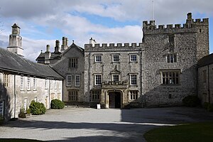
Levens Hall
Manor house in Cumbria, England
Distance: Approx. 1329 meters
Latitude and longitude: 54.259,-2.7764
Levens Hall is a manor house in the Kent valley, near the village of Levens and 5 miles (9 km) south of Kendal in Cumbria, Northern England.

Hincaster
Human settlement in England
Distance: Approx. 2557 meters
Latitude and longitude: 54.256,-2.755
Hincaster is a small hamlet and civil parish in the Unitary Authority of Westmorland and Furness Cumbria, England, located between Kendal and Milnthorpe. In the 2001 census the parish had a population of 195, increasing at the 2011 census to 209. "Caster" often suggests a Roman origin (from the Old English cæster and Latin castrum for "fort"), but no Roman remains are known at Hincaster.

River Gilpin
River in Cumbria, England
Distance: Approx. 2281 meters
Latitude and longitude: 54.25,-2.8
The River Gilpin is a river in the English county of Cumbria. Formerly, the river was in the county of Westmorland. The river rises near Gilpin Lodge in the vicinity of Bowness-on-Windermere and flows in a general south-by-south-easterly direction through Gilpinpark Plantation.

River Pool, Cumbria
River in Cumbria, England
Distance: Approx. 2706 meters
Latitude and longitude: 54.284,-2.8202
The River Pool is a river in the English county of Cumbria. The Pool rises at Waingap near the village of Crook and follows a southerly course, past the township of Underbarrow and into the Lyth Valley, where it joins the River Gilpin.

Levens, Cumbria
Village in Cumbria, England
Distance: Approx. 165 meters
Latitude and longitude: 54.268,-2.789
Levens is a village and civil parish in Westmorland and Furness, Cumbria. It lies within the historic county of Westmorland. In the 2001 census the parish had a population of 1,007, increasing at the 2011 census to 1,049.

Causeway End
Hamlet in England
Distance: Approx. 578 meters
Latitude and longitude: 54.264,-2.789
Causeway End is a hamlet in Cumbria, England.

Cotes, Cumbria
Human settlement in England
Distance: Approx. 680 meters
Latitude and longitude: 54.275,-2.79
Cotes is a hamlet in Cumbria, England.

Sedgwick House, Cumbria
Historic site in Cumbria, England
Distance: Approx. 2328 meters
Latitude and longitude: 54.2765,-2.7538
Sedgwick House is located to the west of the village of Sedgwick, Cumbria, England. It was built as a country house, was later used as a school, and then converted into apartments. The house is recorded in the National Heritage List for England as a designated Grade II listed building.

Hincaster Tunnel
Canal tunnel on the Lancaster Canal
Distance: Approx. 2524 meters
Latitude and longitude: 54.2593,-2.7523
The Hincaster Tunnel is a canal tunnel on the Lancaster Canal at Hincaster, a hamlet in Cumbria, England.
Weather in this IP's area
light rain
7 Celsius
4 Celsius
7 Celsius
8 Celsius
1037 hPa
86 %
1037 hPa
1024 hPa
10000 meters
3.93 m/s
6.6 m/s
281 degree
94 %