Country:
Region:
City:
Latitude and Longitude:
Time Zone:
Postal Code:
IP information under different IP Channel
ip-api
Country
Region
City
ASN
Time Zone
ISP
Blacklist
Proxy
Latitude
Longitude
Postal
Route
Luminati
Country
ASN
Time Zone
Europe/Prague
ISP
SH.cz s.r.o.
Latitude
Longitude
Postal
IPinfo
Country
Region
City
ASN
Time Zone
ISP
Blacklist
Proxy
Latitude
Longitude
Postal
Route
db-ip
Country
Region
City
ASN
Time Zone
ISP
Blacklist
Proxy
Latitude
Longitude
Postal
Route
ipdata
Country
Region
City
ASN
Time Zone
ISP
Blacklist
Proxy
Latitude
Longitude
Postal
Route
Popular places and events near this IP address

Research Institute of Crop Production
Distance: Approx. 3406 meters
Latitude and longitude: 50.08654167,14.30203333
The Crop Research Institute (CRI; previously, Research Institute of Crop Production) (Czech: Výzkumný ústav rostlinné výroby, VÚRV) was established in 1951. During its 60-year existence, the CRIhas been the leading crop-production research institution within the Czech Republic. After most specialised research institutes in the Czech Republic were privatised in 1993, GRI remained the only state-independent institution pursuing both research and consulting activities focussed on problems associated with growing crop plants.

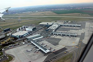
Václav Havel Airport Prague
Airport serving Prague, Czech Republic
Distance: Approx. 2851 meters
Latitude and longitude: 50.1018,14.2632
Václav Havel Airport Prague (Czech: Letiště Václava Havla Praha) Czech pronunciation: [ˈlɛcɪʃcɛ ˈvaːt͡slava ˈɦavla ˈpraɦa] (IATA: PRG, ICAO: LKPR), formerly Prague Ruzyně International Airport (Mezinárodní letiště Praha-Ruzyně, Czech pronunciation: [ˈmɛzɪnaːrodɲiː ˈlɛcɪʃcɛ ˈpraɦa ˈruzɪɲɛ]), is an international airport of Prague, the capital of the Czech Republic. The airport was founded in 1937 when it replaced the Kbely Airport (founded in 1918) as the city's principal airport. It was reconstructed and extended in 1956, 1968, 1997, and 2006.
Hostivice
Town in Central Bohemian, Czech Republic
Distance: Approx. 632 meters
Latitude and longitude: 50.08138889,14.2525
Hostivice (Czech pronunciation: [ˈɦoscɪvɪtsɛ]) is a town in Prague-West District in the Central Bohemian Region of the Czech Republic. It has about 9,200 inhabitants.

Zličín (Prague Metro)
Prague metro station
Distance: Approx. 3499 meters
Latitude and longitude: 50.05361111,14.29055556
Zličín (Czech pronunciation: [ˈzlɪtʃiːn]) is a Prague Metro station and terminus of Line B, located in Třebonice, Prague 17. The station was opened on 11 November 1994 as the western terminus of the extension of Line B from Nové Butovice. Zličín metro station gives direct pedestrian access to the 2004 constructed Metropole shopping mall, and has zero-fare bus links to the nearby Globus, Tesco and Ikea hypermarkets.
Ruzyně
Cadastral Area of Prague in Czech Republic
Distance: Approx. 2559 meters
Latitude and longitude: 50.09805556,14.26944444
Ruzyně is a district of Prague city, part of Prague 6. It has been a part of Prague since 1960. Václav Havel Airport is located in this district.

Chrášťany (Prague-West District)
Municipality in Central Bohemian, Czech Republic
Distance: Approx. 3397 meters
Latitude and longitude: 50.04611111,14.26138889
Chrášťany is a municipality and village in Prague-West District in the Central Bohemian Region of the Czech Republic. It has about 1,200 inhabitants.
Chýně
Town in Central Bohemian, Czech Republic
Distance: Approx. 2766 meters
Latitude and longitude: 50.06083333,14.22694444
Chýně is a town in Prague-West District in the Central Bohemian Region of the Czech Republic. It has about 4,800 inhabitants. The town is a suburb of Prague.

Jeneč
Municipality in Central Bohemian, Czech Republic
Distance: Approx. 3240 meters
Latitude and longitude: 50.0875,14.215
Jeneč is a municipality and village in Prague-West District in the Central Bohemian Region of the Czech Republic. It has about 1,300 inhabitants.

Řepy
Cadastral area of Prague in Prague 6, Czech Republic
Distance: Approx. 3436 meters
Latitude and longitude: 50.06888889,14.30361111
Řepy is a district in the west of Prague, located in and making up most of Prague 17 district, part of the Prague 6 administrative region.
Zličín
Distance: Approx. 3216 meters
Latitude and longitude: 50.05944444,14.29333333
Zličín is a district and cadastral area in the west of Prague, located in an administrative district of the same name, which is part of Prague 5 in the old system and governs the cadastral areas Zličín, Sobín and the northern part of Třebonice. The name is best known among Praguers as the site for a large bus station, Metro terminus and depot and a number of shopping centres and hypermarkets, all of which are named after Zličín, despite belonging to the neighbouring district Třebonice.

Hostivice Ponds
Protected area in the Czech Republic
Distance: Approx. 838 meters
Latitude and longitude: 50.071,14.249
The Hostivice Ponds (Czech: Hostivické rybníky) are a nature monument in Hostivice in the Central Bohemian Region of the Czech Republic. The nature monument consists of a system of three ponds (litovický, Kalý and Břevský), supplied by the Litovický Stream, and their nearest surroundings. This small-scale protected area was established on 14 October 1996 by the District Office of Western Prague with the aim of the conservation of natural communities of the pond system.

Břve
Village in Central Bohemian, Czech Republic
Distance: Approx. 1172 meters
Latitude and longitude: 50.06972222,14.24444444
Břve is a village and administrative part of Hostivice in the Central Bohemian Region of the Czech Republic.
Weather in this IP's area
scattered clouds
5 Celsius
-0 Celsius
4 Celsius
6 Celsius
1010 hPa
82 %
1010 hPa
967 hPa
10000 meters
9.77 m/s
15.43 m/s
250 degree
40 %
07:21:23
16:15:19


