Country:
 Turkey
Region:
City:
Latitude and Longitude:
Time Zone:
Postal Code:
IP information under different IP Channel
ip-api
Country
Region
City
ASN
Time Zone
ISP
Blacklist
Proxy
Latitude
Longitude
Postal
Route
IPinfo
Country
Region
City
ASN
Time Zone
ISP
Blacklist
Proxy
Latitude
Longitude
Postal
Route
MaxMind
Country
Region
City
ASN
Time Zone
ISP
Blacklist
Proxy
Latitude
Longitude
Postal
Route
Luminati
Country
TRASN
Time Zone
Europe/Istanbul
ISP
Netinternet Bilisim Teknolojileri AS
Latitude
Longitude
Postal
db-ip
Country
Region
City
ASN
Time Zone
ISP
Blacklist
Proxy
Latitude
Longitude
Postal
Route
ipdata
Country
Region
City
ASN
Time Zone
ISP
Blacklist
Proxy
Latitude
Longitude
Postal
Route
Popular places and events near this IP address

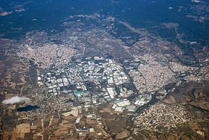
Çerkezköy
District and municipality in Tekirdağ, Turkey
Distance: Approx. 782 meters
Latitude and longitude: 41.28888889,28.00416667
Çerkezköy is a municipality and district of Tekirdağ Province, Turkey. Its area is 86 km2, and its population is 206,829 (2022). Çerkezköy is located in inland Thrace just to the west of the outlying Istanbul districts of Çatalca and Silivri.

Kapaklı
District and municipality in Tekirdağ, Turkey
Distance: Approx. 6340 meters
Latitude and longitude: 41.33333333,27.96666667
Kapaklı (Turkish: [kaˈpakɫɯ]; Greek: Κουπέριον) is a municipality and district of Tekirdağ Province, Turkey. Its area is 182 km2, and its population is 137,514 (2022). The district and municipality Kapaklı was created at the 2013 Turkish local government reorganisation from part of the district of Çerkezköy, including the former municipalities Kapaklı and Karaağaç.
Karaağaç, Tekirdağ
Neighbourhood in Kapaklı, Tekirdağ, Turkey
Distance: Approx. 4664 meters
Latitude and longitude: 41.3,27.95
Karaağaç is a neighbourhood of the municipality and district of Kapaklı, Tekirdağ Province, Turkey. Its population is 5,435 (2022). Before the 2013 reorganisation, it was a town (belde) in the district of Çerkezköy.

Kızılpınar, Çerkezköy
Former town in Marmara, Turkey
Distance: Approx. 3336 meters
Latitude and longitude: 41.26666667,27.96666667
Kızılpınar is a former town in Çerkezköy district of Tekirdağ Province, Turkey. Before the 2013 reorganisation, it was a town (belde). It is subdivided into three mahalle: Atatürk, Gültepe and Namık Kemal.
Kızılpınar Atatürk, Çerkezköy
Neighborhood in Tekirdağ Province, Marmara, Turkey
Distance: Approx. 3234 meters
Latitude and longitude: 41.2683,27.9668
Kızılpınar Atatürk is a neighbourhood of the municipality and district of Çerkezköy, Tekirdağ Province, Turkey. Its population is 27,560 (2022). It covers part of the former town Kızılpınar.

Kızılpınar Namık Kemal, Çerkezköy
Neighbourhood in Çerkezköy, Tekirdağ, Turkey
Distance: Approx. 3555 meters
Latitude and longitude: 41.2613,27.9687
Kızılpınar Namık Kemal is a neighbourhood of the municipality and district of Çerkezköy, Tekirdağ Province, Turkey. Its population is 8,087 (2022). It covers part of the former town Kızılpınar.

Kızılpınar Gültepe, Çerkezköy
Neighbourhood in Çerkezköy, Tekirdağ, Turkey
Distance: Approx. 2830 meters
Latitude and longitude: 41.2657,27.9751
Kızılpınar Gültepe is a neighbourhood of the municipality and district of Çerkezköy, Tekirdağ Province, Turkey. Its population is 18,621 (2022). It covers part of the former town Kızılpınar.

Gazi Osman Paşa, Çerkezköy
Neighbourhood in Çerkezköy, Tekirdağ, Turkey
Distance: Approx. 720 meters
Latitude and longitude: 41.288,27.9963
Gazi Osman Paşa is a neighbourhood of the municipality and district of Çerkezköy, Tekirdağ Province, Turkey. Its population is 15,840 (2022). It covers part of the town centre of Çerkezköy.

Gazi Mustafa Kemal Paşa, Çerkezköy
Neighbourhood in Çerkezköy, Tekirdağ, Turkey
Distance: Approx. 753 meters
Latitude and longitude: 41.2888,28.0035
Gazi Mustafa Kemal Paşa is a neighbourhood of the municipality and district of Çerkezköy, Tekirdağ Province, Turkey. Its population is 21,297 (2022). It covers part of the town centre of Çerkezköy.
Weather in this IP's area
clear sky
29 Celsius
29 Celsius
29 Celsius
29 Celsius
1010 hPa
42 %
1010 hPa
993 hPa
10000 meters
3.6 m/s
170 degree
07:08:55
18:43:31