Country:
Region:
City:
Latitude and Longitude:
Time Zone:
Postal Code:
IP information under different IP Channel
ip-api
Country
Region
City
ASN
Time Zone
ISP
Blacklist
Proxy
Latitude
Longitude
Postal
Route
Luminati
Country
Region
15
City
baixadabanheira
ASN
Time Zone
Europe/Lisbon
ISP
Servicos De Comunicacoes E Multimedia S.A.
Latitude
Longitude
Postal
IPinfo
Country
Region
City
ASN
Time Zone
ISP
Blacklist
Proxy
Latitude
Longitude
Postal
Route
db-ip
Country
Region
City
ASN
Time Zone
ISP
Blacklist
Proxy
Latitude
Longitude
Postal
Route
ipdata
Country
Region
City
ASN
Time Zone
ISP
Blacklist
Proxy
Latitude
Longitude
Postal
Route
Popular places and events near this IP address

Portalegre, Portugal
Municipality in Alentejo, Portugal
Distance: Approx. 2837 meters
Latitude and longitude: 39.31666667,-7.41666667
Portalegre (pronounced [puɾtɐˈlɛɣɾɨ] ) is a municipality in Portugal. The population as of 2011 was 22,368, in an area of 447.14 square kilometres (172.64 sq mi). The municipality is located by the Serra de São Mamede in the Portalegre District.

Portalegre District
District of Portugal
Distance: Approx. 306 meters
Latitude and longitude: 39.29111111,-7.43194444
Portalegre District (Portuguese: Distrito de Portalegre [puɾtɐˈlɛɣɾɨ] ) is located in the east of Portugal. The district capital is the city of Portalegre. As of 2021, it is the least populous district of Portugal.

Castelo de Vide
Municipality in Alentejo, Portugal
Distance: Approx. 8575 meters
Latitude and longitude: 39.33333333,-7.51666667
Castelo de Vide (European Portuguese pronunciation: [kɐʃˈtɛlu ðɨ ˈvidɨ] ) is a municipality in Portugal, with a population of 3,407 inhabitants in 2011, in an area of 264.91 square kilometres (102.28 sq mi).
Ribeira de Nisa e Carreiras
Civil parish in Alentejo, Portugal
Distance: Approx. 6257 meters
Latitude and longitude: 39.35,-7.43
Ribeira de Nisa e Carreiras is a civil parish in the municipality of Portalegre, Portugal. It was formed in 2013 by the merger of the former parishes Ribeira de Nisa and Carreiras. The population in 2011 was 1,949, in an area of 50.43 km2.
Serra de São Mamede Natural Park
Protected area in Portalegre District, Portugal
Distance: Approx. 9004 meters
Latitude and longitude: 39.345,-7.35027778
Serra de São Mamede Natural Park is a natural park in the Serra de São Mamede range, Portugal. It is one of the 30 areas which are officially under protection in the country.

Castle of Portalegre
Portuguese medieval castle
Distance: Approx. 292 meters
Latitude and longitude: 39.2912,-7.4308
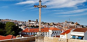
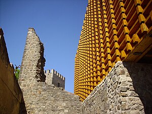
The Castle of Portalegre (Portuguese: Castelo de Portalegre) is a Portuguese medieval castle in the civil parish of Sé e São Lourenço, municipality of Portalegre, district of Portalegre. It stands out over the older part of the town because of its imposing location over a higher area and because of the contrast between its dark walls and the prevailing whitewashed houses. It served chiefly as a defence of the frontier zone in front of Castile.

Alto Alentejo (intermunicipal community)
Intermunicipal community in Alentejo, Portugal
Distance: Approx. 436 meters
Latitude and longitude: 39.29,-7.43
The Comunidade Intermunicipal do Alto Alentejo (Portuguese pronunciation: [ˈaltu ɐlẽˈtɛʒu]; English: Upper Alentejo) is an administrative division in Portugal. It was created in 2009. The seat of the intermunicipal community is Portalegre.

Roman villa of Ammaia
Roman ruins in Portugal
Distance: Approx. 9251 meters
Latitude and longitude: 39.36933056,-7.38639722
The Roman ruins of Ammaia are located in Portugal within the Nature Park of the Serra de São Mamede, a mountainous expanse of forest in the civil parish of São Salvador da Aramenha, municipality of Marvão, along the border with Spain.

Serra de São Mamede
Protected area in Portugal
Distance: Approx. 7094 meters
Latitude and longitude: 39.28333333,-7.35
Serra de São Mamede (English: Saint Mammes Range) is a mountain range in Portalegre District, Portugal. This range is named after Saint Mammes. Together with the Serra de Arraiolos, the Serra de São Mamede is one of the few places in the Alentejo region where there might be snow in the winter.

Sé de Portalegre
Distance: Approx. 368 meters
Latitude and longitude: 39.29113611,-7.43375278
The Sé de Portalegre, also known as the Cathedral of Portalegre (Portuguese: Catedral de Portalegre) is a cathedral in Portalegre, Portugal. It is classified as a national monument. Construction started in 1556 and ended in the early 17th century.
Weather in this IP's area
overcast clouds
12 Celsius
11 Celsius
12 Celsius
12 Celsius
1017 hPa
80 %
1017 hPa
963 hPa
10000 meters
2.5 m/s
4.51 m/s
60 degree
100 %
07:15:59
17:13:49
