88.212.165.64 - IP Lookup: Free IP Address Lookup, Postal Code Lookup, IP Location Lookup, IP ASN, Public IP
Country:
 Great Britain
Region:
City:
Location:
Time Zone:
Postal Code:
ISP:
ASN:
language:
User-Agent:
Proxy IP:
Blacklist:
IP information under different IP Channel
ip-api
Country
Region
City
ASN
Time Zone
ISP
Blacklist
Proxy
Latitude
Longitude
Postal
Route
db-ip
Country
Region
City
ASN
Time Zone
ISP
Blacklist
Proxy
Latitude
Longitude
Postal
Route
IPinfo
Country
Region
City
ASN
Time Zone
ISP
Blacklist
Proxy
Latitude
Longitude
Postal
Route
IP2Location
88.212.165.64Country
gbRegion
england
City
oxford
Time Zone
Europe/London
ISP
Language
User-Agent
Latitude
Longitude
Postal
ipdata
Country
Region
City
ASN
Time Zone
ISP
Blacklist
Proxy
Latitude
Longitude
Postal
Route
Popular places and events near this IP address

St Scholastica Day riot
1355 riot in England
Distance: Approx. 89 meters
Latitude and longitude: 51.75194444,-1.25722222
The St Scholastica Day riot took place in Oxford, England, on 10 February 1355, Saint Scholastica's Day. The disturbance began when two students from the University of Oxford complained about the quality of wine served to them in the Swindlestock Tavern, which stood on Carfax, in the centre of the town. The students quarrelled with the taverner; the argument quickly escalated to blows.
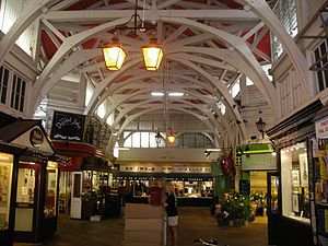
Covered Market, Oxford
Historic market in central Oxford, England
Distance: Approx. 74 meters
Latitude and longitude: 51.7527,-1.2567
The Covered Market is a historic market with permanent stalls and shops in a large covered structure in central Oxford, England. It was designated a Grade II listed building in 2000.

Shepherd & Woodward
Distance: Approx. 73 meters
Latitude and longitude: 51.752332,-1.254968
Shepherd & Woodward are a traditional clothing outfitters in High Street, Oxford, England. In particular, they provide academic gowns and other clothing for the University of Oxford. The shop's origins date back to 1845.

The Bear, Oxford
Pub in Oxford, England
Distance: Approx. 81 meters
Latitude and longitude: 51.7515,-1.2557
The Bear (historically associated with The Bear Inn) is a pub in Oxford, England, that was founded in 1774 as The Jolly Trooper. It stands on the corner of Alfred Street and Blue Boar Street, opposite Bear Lane in the centre of Oxford, just north of Christ Church, on the site of St Edward's churchyard. It was converted from the early 17th century residence of the stableman (ostler) for the coaching inn, The Bear Inn, which was on the High Street, Oxford.

Alfred Street
Street in central Oxford, England
Distance: Approx. 36 meters
Latitude and longitude: 51.7519,-1.2558
Alfred Street is a street running between the High Street to the north and the junction with Blue Boar Street and Bear Lane at the southern end, in central Oxford, England. To the south is Christ Church, one of Oxford University's historic colleges. The Bear is an historic public house located on the west side of Alfred Street at the southern end.

Blue Boar Street
Street in central Oxford, England
Distance: Approx. 102 meters
Latitude and longitude: 51.7513,-1.2563
Blue Boar Street is a narrow historic street running between St Aldate's to the west and the southern end of Alfred Street to the east, in central Oxford, England. It is located just north of Christ Church. At the western end is the Museum of Oxford and the Town Hall to the north.
Bear Lane
Street in central Oxford, England
Distance: Approx. 91 meters
Latitude and longitude: 51.7516,-1.2551
Bear Lane is a short historic street in central Oxford, England. The lane is located just north of Christ Church. It runs between the junction of Blue Boar Street and Alfred Street to the west, and King Edward Street and the north of Oriel Square to the east.

Ben's Cookies
Distance: Approx. 81 meters
Latitude and longitude: 51.75277,-1.256737
Ben's Cookies is an international chain of shops that bake and sell cookies. After making cookies at home, Helge Rubinstein opened a stall to sell them in Oxford's Covered Market in 1984. The cookies can usually be purchased warm as they are baked on-site in the shops.

Vine Hall, Oxford
Former hall of the University of Oxford
Distance: Approx. 98 meters
Latitude and longitude: 51.7514,-1.2554
Vine Hall was an academic hall of the University of Oxford, located on Alfred Street in the 16th century. It became a part of the Peckwater Quadrangle of Christ Church, Oxford. The building gave its name to the previous name for Alfred Street, particularly the southwards continuation of it; Vine Hall Lane.

All Saints' Church, Oxford
Church in Oxford, United Kingdom
Distance: Approx. 45 meters
Latitude and longitude: 51.7525,-1.25555556
All Saints Church is a former church on the north side of the High Street in central Oxford, England, on the corner of Turl Street. It is now the library of Lincoln College. This former church is Grade I listed.

Vincent's Club
Private members' club in Oxford
Distance: Approx. 76 meters
Latitude and longitude: 51.7522,-1.2549
Vincent's Club, popularly known as Vinnie's, is a private members' club in Oxford. The club's membership consists predominantly, but not exclusively, of sporting blues of the University of Oxford.

St Columba's United Reformed Church, Oxford
Distance: Approx. 56 meters
Latitude and longitude: 51.7517,-1.2559
St Columba's United Reformed Church is a congregation of the United Reformed Church (URC) in the centre of the city of Oxford. It is located on Alfred Street, off the High Street.
Weather in this IP's area
broken clouds
4 Celsius
2 Celsius
3 Celsius
4 Celsius
1021 hPa
92 %
1021 hPa
1011 hPa
10000 meters
2.06 m/s
360 degree
75 %