Country:
Region:
City:
Latitude and Longitude:
Time Zone:
Postal Code:
IP information under different IP Channel
ip-api
Country
Region
City
ASN
Time Zone
ISP
Blacklist
Proxy
Latitude
Longitude
Postal
Route
Luminati
Country
Region
38
City
naxxar
ASN
Time Zone
Europe/Malta
ISP
Melita Limited
Latitude
Longitude
Postal
IPinfo
Country
Region
City
ASN
Time Zone
ISP
Blacklist
Proxy
Latitude
Longitude
Postal
Route
db-ip
Country
Region
City
ASN
Time Zone
ISP
Blacklist
Proxy
Latitude
Longitude
Postal
Route
ipdata
Country
Region
City
ASN
Time Zone
ISP
Blacklist
Proxy
Latitude
Longitude
Postal
Route
Popular places and events near this IP address

Sliema
Local council in Eastern Region, Malta
Distance: Approx. 415 meters
Latitude and longitude: 35.91222222,14.50416667
Sliema (Maltese: Tas-Sliema Maltese pronunciation: [tɐsˈslɪː.mɐ]) is a town located on the northeast coast of Malta in the Northern Harbour District. It is a major residential and commercial area and a centre for shopping, bars, dining, and café life. It is also the most densely populated town on the island.

Balluta Bay
Bay on the northeast coast of Malta
Distance: Approx. 988 meters
Latitude and longitude: 35.915,14.494
Balluta Bay is a bay on the northeast coast of Malta within St. Julian's. It is a popular recreation spot used for swimming, diving, and water sports, with a triangular pjazza surrounded by cafés and shaded by Judas trees.
Saint James Capua Hospital
Hospital in Sliema, Malta
Distance: Approx. 343 meters
Latitude and longitude: 35.9131,14.5033
Saint James Capua Hospital is a private hospital located in Sliema, Malta. The hospital was founded in 1996 as the Capua Palace Hospital, named for the Palazzo Capua on whose former gardens the hospital was constructed. In 2002 the hospital was taken over by Saint James Hospital Group, which owns other hospitals in Malta, Libya and Hungary.

Palazzo Capua
Distance: Approx. 412 meters
Latitude and longitude: 35.91263889,14.50275
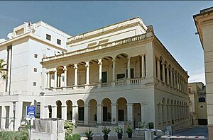
Palazzo Capua, also known as Capua Palace, is an early 19th-century Neoclassic palace in Sliema, Malta. It was built by a Russian banker who named it Selma Hall. It later came into the possession of the Prince of Capua Carlo de Borbon, and his wife Penelope Caroline Smyth, for whom it is still named today.

Stella Maris Church, Sliema
Church in Sliema, Malta
Distance: Approx. 435 meters
Latitude and longitude: 35.91202778,14.50422222
The Stella Maris Parish Church is a Roman Catholic parish located in Sliema, Malta. It is the matrice of the other parish churches in Sliema and Gżira being the oldest parish church dating from 1878.
Our Lady of the Sacred Heart Parish Church
Church in Sliema, Malta
Distance: Approx. 687 meters
Latitude and longitude: 35.91069444,14.50080556
The Sanctuary of Our Lady of the Sacred Heart in Sliema, Malta was founded in 1877, and has been a parish church since 1918.

Carmelite Church, Balluta
Church in St Julian's, Malta
Distance: Approx. 904 meters
Latitude and longitude: 35.91463889,14.495
The Parish Church of Our Lady of Mount Carmel, or simply known as the Carmelite Church or Balluta Parish Church, is a neo-gothic Roman Catholic parish church located in Balluta Bay in the town of St Julian's, Malta.

The Green House, Sliema
Historic townhouse in Sliema, Malta
Distance: Approx. 866 meters
Latitude and longitude: 35.90875,14.50111111
The Green House (Maltese: Id-Dar il-Ħadra) was a late 19th-century vernacular townhouse in Sliema, Malta. The historic residence was an icon in the area, situated at the end of St Mary Street of which name of street derives from the niche on the façade of the building. The façade was notably characterized by its dark green colour which had made it a noticeable landmark.
Malta Protestant College
Distance: Approx. 872 meters
Latitude and longitude: 35.91388889,14.49555556
The Malta Protestant College was a short-lived Church of England training college. It was established in 1846 and came under the jurisdiction of George Tomlinson, Bishop of Gibraltar from 1842 to 1863. Its first principal was John Hickman.

Fatima House
Villa in Sliema, Malta
Distance: Approx. 481 meters
Latitude and longitude: 35.91219444,14.50216667
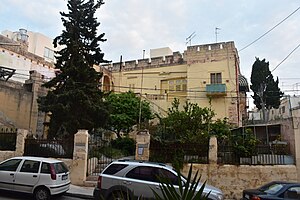
Fatima House (Maltese: Id-Dar ta' Fatima), formerly Villa Bétharram, is a late nineteenth-century villa at 65 High Street, Sliema, Malta. It was purposely built as a family residence for the Galea family, on request of Maltese Senator Alfonso Maria Galea. It is now a residence for females in social needs, sometimes known as Fatima Hostel or Fatima Working Girls' House.

Villa St Ignatius
Villa in St Julian's, Malta
Distance: Approx. 882 meters
Latitude and longitude: 35.9137,14.4955
Villa St Ignatius (Maltese: Villa Sant'Injazju) is a historic villa located in the Balluta area of St Julian's, Malta. It was built in the early 19th century for the English merchant John Watson, and it might be the earliest example of Gothic Revival architecture in the country. The house was converted into a Protestant college in 1846, and it later housed a Jesuit college, which closed down in 1907.

Balluta Buildings
Apartment building in St Julian's, Malta
Distance: Approx. 969 meters
Latitude and longitude: 35.91388889,14.49444444
Balluta Buildings is an Art Nouveau apartment block overlooking Balluta Bay in St Julian's, Malta. It was built in 1928 for the Marquis John Scicluna, and it was constructed to designs of Giuseppe Psaila. The building is considered to be among the finest of the few surviving examples of Art Nouveau architecture in Malta.
Weather in this IP's area
few clouds
19 Celsius
19 Celsius
19 Celsius
19 Celsius
1023 hPa
88 %
1023 hPa
1023 hPa
10000 meters
1.03 m/s
20 %
06:31:32
17:00:01