88.151.25.222 - IP Lookup: Free IP Address Lookup, Postal Code Lookup, IP Location Lookup, IP ASN, Public IP
Country:
 Ireland
Region:
City:
Location:
Time Zone:
Postal Code:
ISP:
ASN:
language:
User-Agent:
Proxy IP:
Blacklist:
IP information under different IP Channel
ip-api
Country
Region
City
ASN
Time Zone
ISP
Blacklist
Proxy
Latitude
Longitude
Postal
Route
db-ip
Country
Region
City
ASN
Time Zone
ISP
Blacklist
Proxy
Latitude
Longitude
Postal
Route
IPinfo
Country
Region
City
ASN
Time Zone
ISP
Blacklist
Proxy
Latitude
Longitude
Postal
Route
IP2Location
88.151.25.222Country
ieRegion
wexford
City
enniscorthy
Time Zone
Europe/Dublin
ISP
Language
User-Agent
Latitude
Longitude
Postal
ipdata
Country
Region
City
ASN
Time Zone
ISP
Blacklist
Proxy
Latitude
Longitude
Postal
Route
Popular places and events near this IP address
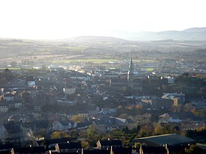
Enniscorthy
Town in County Wexford, Ireland
Distance: Approx. 565 meters
Latitude and longitude: 52.502064,-6.565876
Enniscorthy (Irish: Inis Córthaidh) is the second-largest town in County Wexford, Ireland. The town is located on the picturesque River Slaney and in close proximity to the Blackstairs Mountains and Ireland's longest beach, Curracloe. The Placenames Database of Ireland sheds no light on the origins of the town's name.

Enniscorthy railway station
Station in County Wexford, Ireland
Distance: Approx. 696 meters
Latitude and longitude: 52.5044,-6.5662
Enniscorthy railway station (Irish: Stáisiún Inis Córthaidh) is a railway station in County Wexford, Ireland. It is in the centre of the town of Enniscorthy.

River Bann (County Wexford)
River in Wexford, Ireland
Distance: Approx. 5502 meters
Latitude and longitude: 52.55,-6.55
The River Bann (Irish: An Bhanna) is a large river in County Wexford, in the southeast of the Republic of Ireland.

Battle of Enniscorthy
Military action during the Irish Rebellion of 1798
Distance: Approx. 556 meters
Latitude and longitude: 52.5019,-6.5658
The Battle of Enniscorthy was a land battle fought during the Irish Rebellion of 1798, on 28 May 1798, when an overwhelming force of rebels assailed the town of Enniscorthy, County Wexford, which was defended only by a 300-strong garrison supported by loyalist civilians.

St. Aidan's Cathedral
Church in County Wexford, Ireland
Distance: Approx. 897 meters
Latitude and longitude: 52.50222222,-6.57083333
St. Aidan's Cathedral (Irish: Ardeaglais Naomh Aodháin) is the cathedral church of the Roman Catholic Diocese of Ferns. It is located in Enniscorthy, County Wexford, in Ireland.

Enniscorthy Castle
Historic site in County Wexford, Ireland
Distance: Approx. 638 meters
Latitude and longitude: 52.50145,-6.56716
Enniscorthy Castle is situated in Enniscorthy, County Wexford, Ireland. Construction on the castle commenced in the late 1190s and was first occupied by its Norman owners in 1203 A.D. on the site of a previous wooden castle they had erected some years earlier.

Vinegar Hill Windmill
Ruined mill in County Wexford, Ireland
Distance: Approx. 321 meters
Latitude and longitude: 52.50147,-6.5532
Vinegar Hill Windmill or Templeshannon Windmill is a tower mill on Vinegar Hill, Enniscorthy, County Wexford.

National 1798 Rebellion Centre
Distance: Approx. 920 meters
Latitude and longitude: 52.49666,-6.56955
National 1798 Rebellion Centre (Irish: Ionad Náisiúnta 1798 Éirí Amach) is a heritage centre dedicated to the history of the 1798 Rebellion located in Enniscorthy, County Wexford.
Coláiste Bríde, Enniscorthy
School in Ireland
Distance: Approx. 237 meters
Latitude and longitude: 52.5028,-6.559
Coláiste Bríde, Enniscorthy is a girls Voluntary Catholic Secondary School located in County Wexford.

St. Senan's Hospital
Hospital in County Wexford, Ireland
Distance: Approx. 1427 meters
Latitude and longitude: 52.48857,-6.5641
St. Senan's Hospital (Irish: Ospidéal Naomh Senan) was a psychiatric hospital in Enniscorthy, County Wexford, Ireland.

Enniscorthy Market House
Municipal building in Enniscorthy, County Wexford, Ireland
Distance: Approx. 789 meters
Latitude and longitude: 52.5019,-6.5693
Enniscorthy Market House (Irish: Teach an Mhargaidh Inis Córthaidh), also known as The County Council and Urban Council Offices (Irish: Oifigí na Comhairle Contae agus na Comhairle Uirbeach), is a municipal building in the Market Square, Enniscorthy, County Wexford, Ireland. The building, which was used as the local market house through much of its life, is now used as a civic building.

Scarawalsh
Barony in County Wexford, Ireland
Distance: Approx. 5502 meters
Latitude and longitude: 52.55,-6.55
Scarawalsh (Irish: Scairbh Bhailis) is a historical barony in northern County Wexford, Ireland. Baronies were mainly cadastral rather than administrative units. They acquired modest local taxation and spending functions in the 19th century before being superseded by the Local Government (Ireland) Act 1898.
Weather in this IP's area
overcast clouds
6 Celsius
2 Celsius
6 Celsius
6 Celsius
1022 hPa
87 %
1022 hPa
1012 hPa
10000 meters
5.95 m/s
8.76 m/s
111 degree
100 %