Country:
Region:
City:
Latitude and Longitude:
Time Zone:
Postal Code:
IP information under different IP Channel
ip-api
Country
Region
City
ASN
Time Zone
ISP
Blacklist
Proxy
Latitude
Longitude
Postal
Route
Luminati
Country
Region
eng
City
barking
ASN
Time Zone
Europe/London
ISP
FastNet International Ltd
Latitude
Longitude
Postal
IPinfo
Country
Region
City
ASN
Time Zone
ISP
Blacklist
Proxy
Latitude
Longitude
Postal
Route
db-ip
Country
Region
City
ASN
Time Zone
ISP
Blacklist
Proxy
Latitude
Longitude
Postal
Route
ipdata
Country
Region
City
ASN
Time Zone
ISP
Blacklist
Proxy
Latitude
Longitude
Postal
Route
Popular places and events near this IP address

Municipal Borough of Barking
Distance: Approx. 806 meters
Latitude and longitude: 51.5358,0.0785
Barking was a local government district, and later civil parish and borough, in southwest Essex, England from 1882 to 1965. It was known as Barking Town from 1882 to 1931. The district included the town of Barking, eastern Beckton and the southwestern part of the Becontree estate.

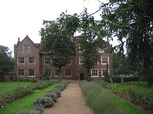
Eastbury Manor House
Manor House in Barking, England
Distance: Approx. 807 meters
Latitude and longitude: 51.53430556,0.09944444
Eastbury Manor House is a Grade I listed building situated in the London Borough of Barking and Dagenham in Greater London, England. It dates to the Elizabethan period, although the land on which it was built was formerly part of the demesne of Barking Abbey. The house is owned by the National Trust but has been managed since the 1930s by the London Borough of Barking and Dagenham and its predecessors.

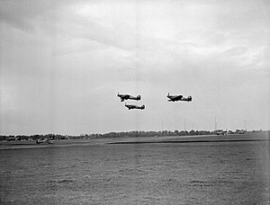
Battle of Barking Creek
Friendly fire aviation incident in 1939
Distance: Approx. 748 meters
Latitude and longitude: 51.5282,0.0795
The Battle of Barking Creek was a friendly fire incident over the East Coast of England in the earliest days of the Second World War. On 6 September 1939, aircraft from several 11 Group, RAF Fighter Command squadrons, were scrambled to intercept German aircraft detected by radar (RDF) flying towards the English coast. The radar plots were reflections of British aircraft flying inland and Spitfire fighters sent to intercept shot down two Hurricanes in error, killing one of the pilots, the first death of a British fighter pilot in the war.

The Broadway (theatre)
Distance: Approx. 837 meters
Latitude and longitude: 51.5355,0.0777
The Broadway is a performance venue in Barking town centre. The building was previously a facility known as Barking Assembly Hall, forming part of Barking Town Hall. While it is currently a live working performance venue the building is also one of four campuses for Barking & Dagemham College, hosting the college s production and performance courses.

Greatfields Park
Public park in London
Distance: Approx. 157 meters
Latitude and longitude: 51.531,0.09
Greatfields Park, in the London Borough of Barking and Dagenham, east London, is a public park of just under 6 hectares. It lies just north of the A13 road (Alfreds Way, Barking bypass trunk road), and is bounded on other sides by Greatfields Road, Movers Lane, and Perth Road. It contains tennis courts, playgrounds, flower gardens, and grass areas for football and other games.

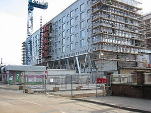
Barking Learning Centre
Community centre in London, England
Distance: Approx. 771 meters
Latitude and longitude: 51.5364,0.0798
The Barking Learning Centre, in the London Borough of Barking and Dagenham, is a community-based learning facility. The centre is located in Barking Town Square and hosts a library, a cafe, an art gallery, a sauna and spa, and offers a range of courses and qualifications. It was constructed on the site of the much-lamented former Barking Library.

Barking Market
Market in Barking, London, England
Distance: Approx. 883 meters
Latitude and longitude: 51.537,0.0785
Barking Market (also called Barking Town Centre Market) is a market located in Barking in the London Borough of Barking and Dagenham in East London, England. It operates on Monday, Tuesday, Thursday, Friday and Saturday. Barking has an ancient market right issued between 1175 and 1179.

Christ Church, Barking
Anglican church in London, England
Distance: Approx. 877 meters
Latitude and longitude: 51.52845,0.0997
Christ Church, Barking or Christ Church, Thames View is a Church of England church on the Thames View estate in Barking, Greater London. It was built between 1958 and 1959 as a chapel of ease to St Patrick's. From the late 1970s until 1 January 2017 it formed a team parish with St Patrick's and St Margaret's.

St Patrick's Church, Barking
Church in Barking, London
Distance: Approx. 507 meters
Latitude and longitude: 51.5337,0.0952
St Patrick's Church is a grade II listed church on Blake Avenue in the Eastbury district in Barking. It was formed in 1924 as the temporary Church of the Ascension, which was turned into a parish hall in 1940 after being replaced by the permanent brown-brick church, dedicated to Saint Patrick and designed in the Moderne style by A. E. Wiseman. A parish was formed for the permanent church in 1939 by splitting an area off from that of St Margaret's.

Barking Town Hall
Municipal building in London, England
Distance: Approx. 811 meters
Latitude and longitude: 51.5358,0.0784
Barking Town hall is a municipal building in Clockhouse Avenue, Barking, London, England. The town hall, which is the headquarters of Barking and Dagenham London Borough Council, is a locally listed building.

East End Women's Museum
Women's museum in London Barking, United Kingdom
Distance: Approx. 926 meters
Latitude and longitude: 51.53377778,0.07533333
East End Women's Museum (EEWM) is a virtual, pop-up museum and the only dedicated women's museum in England. It was established in 2015 as a positive protest to a "Jack the Ripper Museum" in Cable Street. While the EEWM sought to open a permanent location in Barking town centre in 2023, the museum faced difficulties finalising the lease.

Old Town Hall, Barking
Municipal building in London, England
Distance: Approx. 867 meters
Latitude and longitude: 51.537,0.0788
The Old Town Hall is a former municipal building on East Street in Barking, London. The building, which was converted for use as a magistrates' court in 1960 and more recently for residential use, is a Grade II listed building.
Weather in this IP's area
few clouds
10 Celsius
7 Celsius
9 Celsius
11 Celsius
1014 hPa
74 %
1014 hPa
1013 hPa
10000 meters
5.14 m/s
250 degree
20 %
07:21:50
16:07:47