Country:
 Great Britain
Region:
City:
Latitude and Longitude:
Time Zone:
Postal Code:
IP information under different IP Channel
ip-api
Country
Region
City
ASN
Time Zone
ISP
Blacklist
Proxy
Latitude
Longitude
Postal
Route
IPinfo
Country
Region
City
ASN
Time Zone
ISP
Blacklist
Proxy
Latitude
Longitude
Postal
Route
MaxMind
Country
Region
City
ASN
Time Zone
ISP
Blacklist
Proxy
Latitude
Longitude
Postal
Route
Luminati
Country
GBASN
Time Zone
Europe/London
ISP
RETN Limited
Latitude
Longitude
Postal
db-ip
Country
Region
City
ASN
Time Zone
ISP
Blacklist
Proxy
Latitude
Longitude
Postal
Route
ipdata
Country
Region
City
ASN
Time Zone
ISP
Blacklist
Proxy
Latitude
Longitude
Postal
Route
Popular places and events near this IP address

Chrisp Street Market
Distance: Approx. 178 meters
Latitude and longitude: 51.5125,-0.0144
Chrisp Street Market is the central marketplace and town centre of Poplar and is located in the London Borough of Tower Hamlets. It was the first purpose-built pedestrian shopping area in the United Kingdom, rebuilt as part of the 1951 Festival of Britain and is directly connected onto the high street, East India Dock Road. It features a prominent clock tower, shops, small retail outlets, pubs, cafes, flats, and 80 market stalls.

St Matthias Old Church
Church in London, England
Distance: Approx. 187 meters
Latitude and longitude: 51.50944444,-0.01611111
St Matthias Old Church is the modern name given to the Poplar Chapel built by the East India Company in 1654, in Poplar. The church is designated a Grade II* listed building.

All Saints DLR station
Docklands Light Railway station
Distance: Approx. 187 meters
Latitude and longitude: 51.5108,-0.013
All Saints is a Docklands Light Railway (DLR) station in Poplar in East London. The station is named after nearby All Saints, a Church of England parish church dating from 1821 to 1823. The station entrance is on the East India Dock Road, the high street of Poplar and is opposite Chrisp Street Market while adjacent to the Poplar Baths, it also has two rail sidings directly west of the station forming part of Poplar DLR depot.
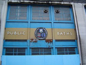
Poplar Baths
Former public bath house in Poplar, London
Distance: Approx. 110 meters
Latitude and longitude: 51.5109,-0.0141
Poplar Baths on the East India Dock Road in Poplar, London is a former public bath house and Grade II listed building that was constructed in 1933 and closed to the public in 1988. The Baths are adjacent to All Saints DLR station. A campaign to restore the baths won the support of Tower Hamlets Council in 2010 and the construction company Guildmore was appointed to complete the works to create a new leisure centre incorporating a swimming pool, gymnasium and affordable housing on adjacent land.
Poplar (East India Road) railway station
Former railway station in England
Distance: Approx. 177 meters
Latitude and longitude: 51.511,-0.0131
Poplar (East India Road) was a railway station located on the East India Dock Road in Poplar, London. It was opened in 1866 by the North London Railway. It was the southern passenger terminus of the NLR, although goods trains ran on to connect to the London and Blackwall Railway (LBR) for the East India Docks or to the LBR's Millwall Extension Railway for the West India Docks.

Trinity Independent Chapel
Victorian church in poplar, London l
Distance: Approx. 227 meters
Latitude and longitude: 51.51138889,-0.01888889
The Trinity Independent Chapel (also known as the Congregational or Methodist chapel) was an early Victorian church in Poplar. It was destroyed by a V-2 rocket hit during the Second World War, and later re-built in Modernist style. In the late 1990s the building was sold to the Calvary Charismatic Baptist Church, and since then has served as their Prayer Temple and international headquarters.

Poplar Rates Rebellion Mural
Mural in Poplar, London, England
Distance: Approx. 210 meters
Latitude and longitude: 51.50963,-0.01755
The Poplar Rates Rebellion Mural is a mural in Hale Street, Poplar, London, London. It is painted on the wall of the depot of Tower Hamlets Parks Department. The mural commemorates the Poplar Rates Rebellion of 1921, when Poplar Borough Council, led by former mayor George Lansbury, refused to pay precepts to London County Council, the Metropolitan Police, the Metropolitan Asylums Board and the Metropolitan Water Board, as a protest against the inequity of the system of local rates.

Poplar Recreation Ground Memorial
War memorial in London
Distance: Approx. 91 meters
Latitude and longitude: 51.5107,-0.0168
The Poplar Recreation Ground Memorial is a memorial to 18 children killed at Upper North Street School in Poplar on 13 June 1917, by the first daylight bombing attack on London by fixed-wing aircraft.

East India Dock Road
Major arterial route in London
Distance: Approx. 217 meters
Latitude and longitude: 51.51123,-0.01252
East India Dock Road is a major arterial route from Limehouse to Canning Town in London. The road takes its name from the former East India Docks in the Port of London. To the west it becomes Commercial Road and to the east Newham Way.

Meridian House (Poplar)
Distance: Approx. 226 meters
Latitude and longitude: 51.50908,-0.01594
Meridian House is located on No. 115 Poplar High Street. It was built in 1801-2 by the East India Company, to house the chaplain serving the company's almshouses and chapel.

Chrisp Street Market Clock Tower
Clock tower in London
Distance: Approx. 188 meters
Latitude and longitude: 51.51245,-0.01402
Chrisp Street Market Clock Tower is a Grade II listed landmark located in Market Square, Chrisp Street, Poplar. It was designed by the architect Frederick Gibberd as part of the Lansbury Estate for the Festival of Britain, 1951. The clock tower is an example of early post-war architecture, and an aesthetic that became known as the "Festival Style".

Old Town Hall, Poplar
Municipal building in London, England
Distance: Approx. 223 meters
Latitude and longitude: 51.5091,-0.0157
The Old Town Hall is a former municipal building at the corner of Poplar High Street and Woodstock Terrace in Poplar, London. The building, which currently accommodates the Lansbury Heritage Hotel, is a Grade II listed building.
Weather in this IP's area
broken clouds
16 Celsius
16 Celsius
15 Celsius
17 Celsius
1004 hPa
92 %
1004 hPa
1004 hPa
10000 meters
2.57 m/s
110 degree
75 %
06:24:26
19:31:13