Country:
 Switzerland
Region:
City:
Latitude and Longitude:
Time Zone:
Postal Code:
IP information under different IP Channel
ip-api
Country
Region
City
ASN
Time Zone
ISP
Blacklist
Proxy
Latitude
Longitude
Postal
Route
IPinfo
Country
Region
City
ASN
Time Zone
ISP
Blacklist
Proxy
Latitude
Longitude
Postal
Route
MaxMind
Country
Region
City
ASN
Time Zone
ISP
Blacklist
Proxy
Latitude
Longitude
Postal
Route
Luminati
Country
CHRegion
zh
City
adliswil
ASN
Time Zone
Europe/Zurich
ISP
Iway AG
Latitude
Longitude
Postal
db-ip
Country
Region
City
ASN
Time Zone
ISP
Blacklist
Proxy
Latitude
Longitude
Postal
Route
ipdata
Country
Region
City
ASN
Time Zone
ISP
Blacklist
Proxy
Latitude
Longitude
Postal
Route
Popular places and events near this IP address

Kilchberg, Zurich
Municipality in Zurich, Switzerland
Distance: Approx. 1911 meters
Latitude and longitude: 47.31666667,8.55
Kilchberg (High Alemannic: Chilchbèèrg) is a municipality in the district of Horgen in the canton of Zürich in Switzerland. Kilchberg is the site of a regional cemetery.

Adliswil
Municipality in Zurich, Switzerland
Distance: Approx. 890 meters
Latitude and longitude: 47.31666667,8.53333333
Adliswil is a town and a municipality in the district of Horgen in the canton of Zürich in Switzerland. The official language of Adliswil is (the Swiss variety of Standard) German, but the main spoken language is the local variant of the Alemannic Swiss German dialect.

Felsenegg
Mountain in Switzerland
Distance: Approx. 1295 meters
Latitude and longitude: 47.30859722,8.50958333
Felsenegg (el. 804 metres or 2,638 feet) is a vantage point in the canton of Zürich in Switzerland.
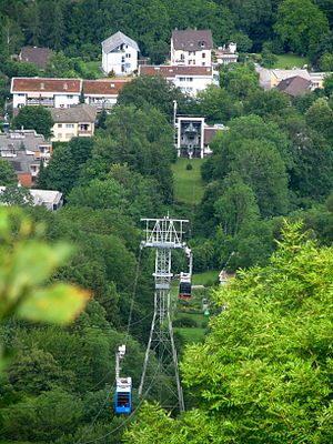
Adliswil-Felsenegg cable car
Distance: Approx. 602 meters
Latitude and longitude: 47.31316667,8.52003333
The Adliswil-Felsenegg cable car (LAF; German: Luftseilbahn Adliswil-Felsenegg or Felseneggbahn) is a cable car in the canton of Zürich in Switzerland. The lower station is located in Adliswil in the Sihl Valley, whilst the upper station is located on the Felsenegg hill on the Albis ridge near the Felsenegg-Girstel TV-tower. The upper station at Felsenegg forms one end of a panoramic walk to the Uetliberg mountain, whilst the lower station is some 400 metres (1,300 ft) from Adliswil railway station.

Felsenegg-Girstel TV-tower
Distance: Approx. 1589 meters
Latitude and longitude: 47.31226389,8.50578611
The Felsenegg Tower is a broadcasting tower located nearby Felseneggbahn mountain station on the Felsenegg vantage point in the canton of Zürich in Switzerland. The tower is owned by Swisscom Broadcast AG and generally not accessible by the public.

Sri Sivasubramaniar Temple
Hindu temple in Switzerland
Distance: Approx. 373 meters
Latitude and longitude: 47.30678333,8.52587778
The Sri Sivasubramaniar Temple is a Hindu temple located in Adliswil in the Sihl Valley in the canton of Zürich, Switzerland.

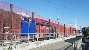
Adliswil railway station
Railway station in Canton of Zürich, Switzerland
Distance: Approx. 323 meters
Latitude and longitude: 47.3124,8.524
Adliswil is a railway station in the Sihl Valley, and the municipality of Adliswil, in the Swiss Canton of Zürich. The station is on the Sihltal line, which is operated by the Sihltal Zürich Uetliberg Bahn (SZU). The station is a short walking distance away from the valley station of the aerial lift to Felsenegg and the Albis ridge.

Wildpark-Höfli railway station
Station on the Zürich S-Bahn, Switzerland
Distance: Approx. 1627 meters
Latitude and longitude: 47.296666,8.535079
Wildpark-Höfli is a railway station in the Sihl Valley, and the municipality of Langnau am Albis, in the Swiss Canton of Zurich. The station is on the Sihltal line, which is operated by the Sihltal Zürich Uetliberg Bahn (SZU). It takes its name from the nearby settlement of Höfli, and the Wildpark Langenberg, a nearby zoo.
Sihlau railway station
Railway station in Canton of Zürich, Switzerland
Distance: Approx. 778 meters
Latitude and longitude: 47.303171,8.525219
Sihlau is a railway station in the Sihl Valley, and the municipality of Adliswil, in the Swiss Canton of Zürich. The station is on the Sihltal line, which is operated by the Sihltal Zürich Uetliberg Bahn (SZU). It takes its name from the nearby settlement of Sihlau.

Sood-Oberleimbach railway station
Railway station in north-east Switzerland
Distance: Approx. 1136 meters
Latitude and longitude: 47.319697,8.521501
Sood-Oberleimbach is a railway station in the Sihl Valley, and the municipality of Adliswil, in the Swiss Canton of Zürich. The station is on the Sihltal line, which is operated by the Sihltal Zürich Uetliberg Bahn (SZU).

Langenberg Wildlife Park
Zoo in south of Zürich, Switzerland
Distance: Approx. 1912 meters
Latitude and longitude: 47.293,8.529
Langenberg Wildlife Park (German: Tierpark Langenberg) is a zoo situated in the municipality of Langnau am Albis in the Sihl Valley to the south of the city of Zürich in Switzerland. The wildlife park now forms part of the Zürich Wilderness Park. The park was founded in 1869 by the Zürich city forester Carl Anton Ludwig von Orelli, making it the oldest Swiss wildlife park.
Baldern Castle
Castle in Zürich, Switzerland
Distance: Approx. 1653 meters
Latitude and longitude: 47.31470278,8.50577222
Baldern Castle (German: Burg Baldern or Burgstelle Baldern) is a former castle in the municipality of Stallikon and the canton of Zürich in Switzerland. The remains of the castle comprise a set of earthworks, situated on the Albis ridge at some 810 metres (2,660 ft) above sea level and about 4 kilometres (2.5 mi) south of the summit of Uetliberg. The earthworks are obscured by the site's woodland nature.
Weather in this IP's area
mist
12 Celsius
11 Celsius
10 Celsius
12 Celsius
1022 hPa
94 %
1022 hPa
968 hPa
5000 meters
1.54 m/s
10 degree
100 %
07:51:41
18:29:16