Country:
 Switzerland
Region:
City:
Latitude and Longitude:
Time Zone:
Postal Code:
IP information under different IP Channel
ip-api
Country
Region
City
ASN
Time Zone
ISP
Blacklist
Proxy
Latitude
Longitude
Postal
Route
IPinfo
Country
Region
City
ASN
Time Zone
ISP
Blacklist
Proxy
Latitude
Longitude
Postal
Route
MaxMind
Country
Region
City
ASN
Time Zone
ISP
Blacklist
Proxy
Latitude
Longitude
Postal
Route
Luminati
Country
CHRegion
ag
City
dottingen
ASN
Time Zone
Europe/Zurich
ISP
Iway AG
Latitude
Longitude
Postal
db-ip
Country
Region
City
ASN
Time Zone
ISP
Blacklist
Proxy
Latitude
Longitude
Postal
Route
ipdata
Country
Region
City
ASN
Time Zone
ISP
Blacklist
Proxy
Latitude
Longitude
Postal
Route
Popular places and events near this IP address

Swissair Flight 330
Airline bombing incident in 1970
Distance: Approx. 2981 meters
Latitude and longitude: 47.53638889,8.23972222
Swissair Flight 330 (SR330/SWR330) was a regularly scheduled flight from Zurich Airport in Kloten, Switzerland, to Hong Kong with a planned stopover in Tel Aviv, Israel. A bomb planted by two members of the PLO exploded soon after takeoff, causing the plane to crash, killing all 47 passengers and crew.
Böttstein
Municipality in Aargau, Switzerland
Distance: Approx. 1446 meters
Latitude and longitude: 47.56666667,8.23333333
Böttstein is a municipality in the district of Zurzach in the canton of Aargau in Switzerland.

Klingnauer Stausee
Reservoir near Böttstein, canton of Aargau, Switzerland
Distance: Approx. 2731 meters
Latitude and longitude: 47.58333333,8.23333333
The Klingnauer Stausee (or "Klingnau reservoir") is a reservoir near Böttstein, canton of Aargau, Switzerland, at 47°35′N 8°14′E. The reservoir with a surface of 1.16 km2 (0.45 sq mi) was formed at the construction of a power plant on the Aare river in the 1930s.

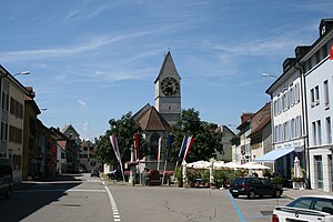
Döttingen, Aargau
Municipality in Aargau, Switzerland
Distance: Approx. 1266 meters
Latitude and longitude: 47.56666667,8.26666667
Döttingen (German: [ˈdœtɪŋən]) is a municipality in the district of Zurzach in the canton of Aargau in Switzerland.
Klingnau
Municipality in Aargau, Switzerland
Distance: Approx. 2377 meters
Latitude and longitude: 47.58333333,8.25
Klingnau is a municipality in the district of Zurzach in the canton of Aargau in Switzerland.

Tegerfelden
Municipality in Aargau, Switzerland
Distance: Approx. 2462 meters
Latitude and longitude: 47.56666667,8.28333333
Tegerfelden is a municipality in the district of Zurzach in the canton of Aargau in Switzerland.
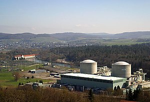
Beznau Nuclear Power Plant
Nuclear power plant in Canton of Aargau, Switzerland
Distance: Approx. 2037 meters
Latitude and longitude: 47.552107,8.228492
The Beznau nuclear power plant (German: Kernkraftwerk Beznau [KKB]) is a nuclear power plant of the Swiss energy utility Axpo, located in the municipality Döttingen, Canton of Aargau, Switzerland, on an artificial island in the Aare river. The plant has been operating since September 1969.

Klingnau Castle
Distance: Approx. 2131 meters
Latitude and longitude: 47.58104167,8.24841389
Klingnau Castle (German: Schloss Klingnau) is a castle in the municipality of Klingnau in the Swiss canton of Aargau.

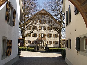
Böttstein Castle
Château
Distance: Approx. 2215 meters
Latitude and longitude: 47.55411111,8.22423056
Böttstein Castle is a castle in the municipality of Böttstein in the canton of Aargau in Switzerland.

Döttingen railway station
Railway station in Döttingen, Switzerland
Distance: Approx. 1524 meters
Latitude and longitude: 47.57526,8.25632694
Döttingen railway station (German: Bahnhof Döttingen) is a railway station in the municipality of Döttingen, in the Swiss canton of Aargau. It is an intermediate stop on the standard gauge Turgi–Koblenz–Waldshut line of Swiss Federal Railways.

Klingnau railway station
Railway station in Switzerland
Distance: Approx. 2244 meters
Latitude and longitude: 47.58209,8.24880694
Klingnau railway station (German: Bahnhof Klingnau) is a railway station in the municipality of Klingnau, in the Swiss canton of Aargau. It is an intermediate stop on the standard gauge Turgi–Koblenz–Waldshut line of Swiss Federal Railways.

DIORIT
Distance: Approx. 3135 meters
Latitude and longitude: 47.53861111,8.22805556
Diorit was an experimental nuclear research reactor at the Swiss Federal Institute for Reactor Research (EIR) in Würenlingen (Canton of Aargau, Switzerland) This nuclear reactor was operated by EIR from 1960 to 1977. Heavy water (D2O) was used as the moderator, as well as the coolant. The initially commissioned reactor had a thermal power of 20 MW. Natural uranium was initially used as fuel, which was later changed to enriched uranium.
Weather in this IP's area
overcast clouds
12 Celsius
12 Celsius
10 Celsius
13 Celsius
1022 hPa
97 %
1022 hPa
983 hPa
10000 meters
0.84 m/s
0.87 m/s
122 degree
100 %
07:53:10
18:29:58