Country:
 Switzerland
Region:
City:
Latitude and Longitude:
Time Zone:
Postal Code:
IP information under different IP Channel
ip-api
Country
Region
City
ASN
Time Zone
ISP
Blacklist
Proxy
Latitude
Longitude
Postal
Route
IPinfo
Country
Region
City
ASN
Time Zone
ISP
Blacklist
Proxy
Latitude
Longitude
Postal
Route
MaxMind
Country
Region
City
ASN
Time Zone
ISP
Blacklist
Proxy
Latitude
Longitude
Postal
Route
Luminati
Country
CHRegion
bl
City
augst
ASN
Time Zone
Europe/Zurich
ISP
Iway AG
Latitude
Longitude
Postal
db-ip
Country
Region
City
ASN
Time Zone
ISP
Blacklist
Proxy
Latitude
Longitude
Postal
Route
ipdata
Country
Region
City
ASN
Time Zone
ISP
Blacklist
Proxy
Latitude
Longitude
Postal
Route
Popular places and events near this IP address

Augusta Raurica
Archaeological site and museum in Switzerland
Distance: Approx. 853 meters
Latitude and longitude: 47.53388889,7.72138889
Augusta Raurica is a Roman archaeological site and an open-air museum in Switzerland located on the south bank of the Rhine river about 20 km east of Basel near the villages of Augst and Kaiseraugst. It is the site of the oldest known Roman colony on the Rhine.

Pratteln
Municipality in Basel-Landschaft, Switzerland
Distance: Approx. 2655 meters
Latitude and longitude: 47.51666667,7.7
Pratteln (Swiss German: Brattele) is a municipality in the canton of Basel-Landschaft in Switzerland, located in the district of Liestal.

Grenzach-Wyhlen
Municipality in Baden-Württemberg, Germany
Distance: Approx. 2860 meters
Latitude and longitude: 47.545,7.67583333
Grenzach-Wyhlen is a municipality in the district of Lörrach in Baden-Württemberg, Germany. It is situated on the right bank of the Rhine, 7 km east of Basel, and 8 km south of Lörrach. It has borders to Inzlingen and Rheinfelden (Baden) in Germany, and Riehen (BS), Birsfelden (BL) and Kaiseraugst (AG) in Switzerland.

Kaiseraugst
Place in Aargau, Switzerland
Distance: Approx. 1254 meters
Latitude and longitude: 47.53805556,7.72944444
Kaiseraugst (Swiss German: Chhäiseraugscht) is a municipality in the district of Rheinfelden in the canton of Aargau in Switzerland. It is named after the Ancient Roman city of Augusta Raurica whose ruins are nearby. The prefix Kaiser- ("imperial") refers to the fact that from medieval times the town formed part of the Habsburg territory of Further Austria, as opposed to the neighbouring village of Augst, which was part of the Canton of Basel in the Old Swiss Confederacy.
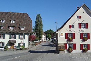
Augst
Place in Basel-Landschaft, Switzerland
Distance: Approx. 684 meters
Latitude and longitude: 47.53333333,7.71666667
Augst (Swiss German: Augscht) is a municipality in the district of Liestal in the canton of Basel-Country in Switzerland. It was known as Augusta Raurica in Roman times.

Ergolz
River in Switzerland
Distance: Approx. 123 meters
Latitude and longitude: 47.53806,7.71386
The Ergolz is the main river in the canton of Basel-Landschaft, Switzerland. It rises on Mount Geisflue in the Faltenjura mountains in the upper region of Basel-Landschaft, on the border with Aargau and Solothurn, and joins the Rhine at Augst. Among the tributaries of the Ergolz are Eibach, Homburgerbach, Diegterbach, Frenke (Anterior and Posterior Frenke), Orisbach, Röserenbach and Violenbach.
Herten (Baden) station
Railway station in Rheinfelden (Baden), Germany
Distance: Approx. 2339 meters
Latitude and longitude: 47.54950694,7.73966306
Herten (Baden) station (German: Bahnhof Herten (Baden)) is a railway station in the town of Rheinfelden, Baden-Württemberg, Germany. The station lies on the High Rhine Railway and the train services are operated by Deutsche Bahn.

Wyhlen station
Railway station in Wyhlen, Germany
Distance: Approx. 1841 meters
Latitude and longitude: 47.54632806,7.69091806
Wyhlen station (German: Bahnhof Wyhlen) is a railway station in the town of Grenzach-Wyhlen, Baden-Württemberg, Germany. The station lies on the High Rhine Railway and the train services are operated by Deutsche Bahn.
Kaiseraugst Nuclear Power Plant
Nuclear Power Plant in Switzerland
Distance: Approx. 2715 meters
Latitude and longitude: 47.54,7.74888889
The site for the Kaiseraugst Nuclear Power Plant is located in north-west Switzerland beside the river at Kaiseraugst, a short distance to the east of Basel. Plans to build and operate the power plant were the subject of increasingly high-profile controversy over many years. The project failed because of bitter and ultimately effective opposition from the local population and because it became a cause célèbre for environmentalist pressure groups in Switzerland and across German speaking central Europe more generally.

Pratteln railway station
Railway station in Switzerland
Distance: Approx. 2448 meters
Latitude and longitude: 47.52266889,7.69081694
Pratteln railway station (German: Bahnhof Pratteln) is a railway station in the municipality of Pratteln, in the Swiss canton of Basel-Landschaft. It is an intermediate stop on the standard gauge Bözberg and Hauenstein lines of Swiss Federal Railways. The 1,000 mm (3 ft 3+3⁄8 in) Basel–Pratteln railway line terminates 160 metres (520 ft) south of the station, and is served by line 14 of the Basel tram network.

Pratteln Salina Raurica railway station
Railway station in Switzerland
Distance: Approx. 927 meters
Latitude and longitude: 47.53068056,7.71079444
Pratteln Salina Raurica railway station (German: Bahnhof Pratteln Salina Raurica) is a railway station in the municipality of Pratteln, in the Swiss canton of Basel-Landschaft. It is an intermediate stop on the Bözberg line and is served by local trains only.

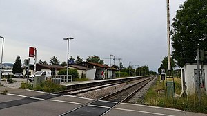
Kaiseraugst railway station
Railway station in Kaiseraugst, Switzerland
Distance: Approx. 850 meters
Latitude and longitude: 47.53858889,7.7241
Kaiseraugst railway station (German: Bahnhof Kaiseraugst) is a railway station in the municipality of Kaiseraugst, in the Swiss canton of Aargau. It is an intermediate stop on the Bözberg line and is served by local trains only.
Weather in this IP's area
overcast clouds
10 Celsius
10 Celsius
9 Celsius
13 Celsius
1022 hPa
95 %
1022 hPa
990 hPa
10000 meters
0.45 m/s
0.89 m/s
90 degree
88 %
07:55:17
18:32:09