Country:
 Lithuania
Region:
City:
Latitude and Longitude:
Time Zone:
Postal Code:
IP information under different IP Channel
ip-api
Country
Region
City
ASN
Time Zone
ISP
Blacklist
Proxy
Latitude
Longitude
Postal
Route
IPinfo
Country
Region
City
ASN
Time Zone
ISP
Blacklist
Proxy
Latitude
Longitude
Postal
Route
MaxMind
Country
Region
City
ASN
Time Zone
ISP
Blacklist
Proxy
Latitude
Longitude
Postal
Route
Luminati
Country
LTRegion
vl
City
lentvaris
ASN
Time Zone
Europe/Vilnius
ISP
UAB Cgates
Latitude
Longitude
Postal
db-ip
Country
Region
City
ASN
Time Zone
ISP
Blacklist
Proxy
Latitude
Longitude
Postal
Route
ipdata
Country
Region
City
ASN
Time Zone
ISP
Blacklist
Proxy
Latitude
Longitude
Postal
Route
Popular places and events near this IP address
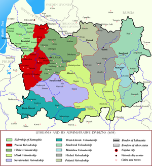
Trakai Voivodeship
Voivodeship of the Grand Duchy of Lithuania
Distance: Approx. 7135 meters
Latitude and longitude: 54.639319,24.935049
Trakai Voivodeship, Trakai Palatinate, or Troki Voivodeship (Latin: Palatinatus Trocensis, Lithuanian: Trakų vaivadija, Polish: Województwo trockie), was a unit of administrative division and local government in the Grand Duchy of Lithuania from 1413 until 1795.
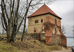
Trakai Peninsula Castle
Castle in Trakai, Lithuania
Distance: Approx. 6963 meters
Latitude and longitude: 54.646,24.937
Trakai Peninsula Castle is one of the castles in Trakai, Lithuania. It is located on a peninsula between southern Lake Galvė and Lake Luka. Built around 1350–1377 by Kęstutis, Duke of Trakai, it was an important defensive structure protecting Trakai and Vilnius, capital of the Grand Duchy of Lithuania, against attacks of the Teutonic Knights.

Senieji Trakai Castle
Distance: Approx. 6072 meters
Latitude and longitude: 54.605,24.98416667
Senieji Trakai Castle was a castle in Senieji Trakai (literally: Old Trakai), Lithuania. The first enclosure-type brick castle was built by Grand Duke Gediminas, who transferred the capital of Lithuania from Kernavė to Trakai (today's Senieji Trakai) before 1321. The wedding of Grand Duke Kęstutis and Birutė was held there and it was the birthplace of the Grand Duke Vytautas in 1350.

Lentvaris
City in Dzūkija, Lithuania
Distance: Approx. 1440 meters
Latitude and longitude: 54.65,25.06666667
Lentvaris (; Polish: Landwarów) is a city in eastern Lithuania, 9 km east of Trakai. It is a transportation hub, as several road and rail routes cross here. Lake Lentvaris is nearby.

Senieji Trakai
Village in Lithuania
Distance: Approx. 6054 meters
Latitude and longitude: 54.61666667,24.96666667
Senieji Trakai (literally: Old Trakai, Polish: Stare Troki) is a historic Lithuanian village located 3 kilometres (1.9 mi) east of Trakai. According to the Lithuanian census of 2011, it has 1,396 inhabitants – Lithuanians, Poles and Russians. The Saint Petersburg–Warsaw Railway passes through Senieji Trakai.

Church of the Visitation of the Blessed Virgin Mary, Trakai
Distance: Approx. 7140 meters
Latitude and longitude: 54.64286111,24.93444444
St. Mary Church in Trakai, Lithuania, is a Roman Catholic church. It was founded by Vytautas the Great in 1409 and constructed in gothic style.

Trakai Kenesa
Former synagouge in Trakai, Lithuania
Distance: Approx. 7236 meters
Latitude and longitude: 54.64777778,24.93277778
The Trakai Kenesa is a former Qaraite Jewish congregation and synagogue, or kenesa, located at 30 Karaimų Street, in Trakai, in the Vilnius County of Lithuania. Designed in the Baroque Revival style, the wooden synagogue was completed in c. 1800, restored in the 1890s. Built on a rectangular plan and covered with a hipped roof with a small annex, the synagogue was larger than the surrounding houses.

Lentvaris Manor
Former manor house in Lentvaris, Lithuania
Distance: Approx. 1408 meters
Latitude and longitude: 54.6589,25.04
Lentvaris Manor is a former residential manor in Lentvaris, Trakai District Municipality, Lithuania. Founded in the 16th century, the manor homestead stands on the northern shore of Lake Lentvaris, which was artificially created by pouring an embankment over the lake. Lentvaris manor is registered in the Register of Cultural Values and is a state protected object, it must also be taken care of by the Department of Cultural Heritage.

Vokė
River in Lithuania
Distance: Approx. 5021 meters
Latitude and longitude: 54.68777778,25.07694444
The Vokė is a river in southeast Lithuania. It is a left tributary of Neris River. The Vokė flows from Papis Lake, near the Merkys.

Varnikai
Village in Aukštaitija, Lithuania
Distance: Approx. 5732 meters
Latitude and longitude: 54.64694444,24.95611111
Varnikai is a small village located in the Trakai District Municipality in Lithuania. The population is 75 inhabitants according to the 2011 census.

Trakų Vokė Manor
Former manor with Neo-Gothic architecture in Traku Voke
Distance: Approx. 4464 meters
Latitude and longitude: 54.63055556,25.10861111
Trakų Vokė Manor (Lithuanian: Trakų Vokės dvaras) is a former residential manor in Trakų Vokė. It is a monument of historicist architecture with elements of Neo-Gothic, classicism, eclectic style, located halfway between Vilnius and Trakai. The Manor was established in the end of the 19th century.

Užutrakis Manor
Residential manor in Užutrakis, Lithuania
Distance: Approx. 6685 meters
Latitude and longitude: 54.6597,24.9438
Užutrakis Manor (Lithuanian: Užutrakio dvaras, Polish: pałac Tyszkiewiczów w Zatroczu) is a late 19th-century residential manor of the Tyszkiewicz family in Užutrakis, on the shore of Lake Galvė, opposite the famous Trakai Castle. It is considered one of the most important monuments of Lithuania’s estate heritage.
Weather in this IP's area
clear sky
11 Celsius
9 Celsius
11 Celsius
11 Celsius
1030 hPa
40 %
1030 hPa
1011 hPa
10000 meters
3.09 m/s
150 degree
07:54:49
18:14:42