Country:
 Germany
Region:
City:
Latitude and Longitude:
Time Zone:
Postal Code:
IP information under different IP Channel
ip-api
Country
Region
City
ASN
Time Zone
ISP
Blacklist
Proxy
Latitude
Longitude
Postal
Route
IPinfo
Country
Region
City
ASN
Time Zone
ISP
Blacklist
Proxy
Latitude
Longitude
Postal
Route
MaxMind
Country
Region
City
ASN
Time Zone
ISP
Blacklist
Proxy
Latitude
Longitude
Postal
Route
Luminati
Country
DEASN
Time Zone
Europe/Berlin
ISP
Host Europe GmbH
Latitude
Longitude
Postal
db-ip
Country
Region
City
ASN
Time Zone
ISP
Blacklist
Proxy
Latitude
Longitude
Postal
Route
ipdata
Country
Region
City
ASN
Time Zone
ISP
Blacklist
Proxy
Latitude
Longitude
Postal
Route
Popular places and events near this IP address

German Aerospace Center
German research center for aerospace and power engineering
Distance: Approx. 2397 meters
Latitude and longitude: 50.8525,7.1225
The German Aerospace Center (German: Deutsches Zentrum für Luft- und Raumfahrt e.V., abbreviated DLR, literally German Center for Air- and Space-flight) is the national center for aerospace, energy and transportation research of Germany, founded in 1969. It is headquartered in Cologne with 35 locations throughout Germany. The DLR is engaged in a wide range of research and development projects in national and international partnerships.
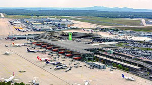
Cologne Bonn Airport
Airport in North Rhine-Westphalia, Germany
Distance: Approx. 561 meters
Latitude and longitude: 50.86583333,7.14277778
Cologne Bonn Airport Konrad Adenauer (German: Flughafen Köln/Bonn „Konrad Adenauer“) (IATA: CGN, ICAO: EDDK) is the international airport of Germany's fourth-largest city Cologne, and also serves Bonn, the former capital of West Germany. With approximately 12.4 million passengers passing through it in 2017, it is the seventh-largest passenger airport in Germany and the third-largest in terms of cargo operations. By traffic units, which combines cargo and passengers, the airport is in fifth position in Germany.

Rösrath
Town in North Rhine-Westphalia, Germany
Distance: Approx. 4426 meters
Latitude and longitude: 50.9,7.18333333
Rösrath (German: [ˈʁøːsˌʁaːt]; Kölsch: Röhsroth [ˈʁœs²ˌʁɔt²]) is a town in the Rheinisch-Bergischer Kreis (district) in North Rhine-Westphalia, Germany. The earliest known documents mentioning the settlement Rösrath can be found in documents dated to 1356. There have been findings of Paleolithic and Mesolithic tools in the town area Forsbach.

European Astronaut Centre
ESA field center in Köln, Germany
Distance: Approx. 2195 meters
Latitude and longitude: 50.85194444,7.13111111
The European Astronaut Centre (EAC) (German: Europäisches Astronautenzentrum, French: Centre des astronautes européens), is an establishment of the European Space Agency and home of the European Astronaut Corps. It is near to Cologne, Germany, and is subdivided into six separate arms, these being Astronaut Training, Space Medicine, Astronaut Management, Human Exploration of the Moon as part of the Spaceship EAC initiative and Communications. It provides training facilities for European and international partner astronauts (including a neutral buoyancy pool), particularly regarding ESA hardware for the ISS such as Columbus and formerly the ATV. The overall European Astronaut Centre organisation is also in charge of the organisation of the training of European astronauts in the centers of other partners, such as the United States (NASA Johnson Space Center), Russia (Star City), Canada (Saint-Hubert) or Japan (Tsukuba).

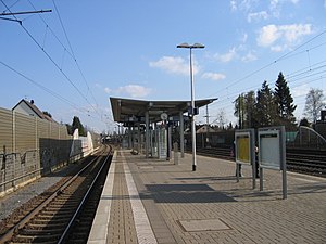
Cologne/Bonn Airport station
Station at Cologne Bonn Airport
Distance: Approx. 1751 meters
Latitude and longitude: 50.87888889,7.11944444
Cologne/Bonn Airport station (German: Bahnhof Köln/Bonn Flughafen) is a station at Cologne Bonn Airport in the German state of North Rhine-Westphalia. It was built as part of the Cologne–Frankfurt high-speed rail line and opened in June 2004 on the approximately 15-kilometre-long (9.3 mi) Cologne Airport loop line. It is served by Intercity-Express (ICE), Rhine-Ruhr S-Bahn and regional services.

Eil, Cologne
City quarter no. 705 of Cologne, Germany
Distance: Approx. 5391 meters
Latitude and longitude: 50.8936,7.0731
Eil is a suburb of Cologne, Germany located in the city district of Porz, south-east of the city center. With an area totalling 16,24 km2, it is the largest suburb in the city, although not all of the land is built up.

Porz (Rhein) station
Railway station in Cologne, Germany
Distance: Approx. 5514 meters
Latitude and longitude: 50.88295,7.064665
Porz (Rhein) is a railway station situated at Porz, Cologne in the German state of North Rhine-Westphalia on the Sieg and East Rhine Railways. It is served by the S12 line of the Rhine-Ruhr S-Bahn. It is classified by Deutsche Bahn as a category 4 station.

Porz-Wahn station
Railway station in Cologne, Germany
Distance: Approx. 4542 meters
Latitude and longitude: 50.8581,7.07925
Porz-Wahn is a railway station situated at Porz, Cologne in the German state of North Rhine-Westphalia on the Sieg and East Rhine Railways. It is served by the S12 and S13 lines of the Rhine-Ruhr S-Bahn. Both lines operate towards Cologne at 20-minute intervals, so together they provide a 10-minute interval S-Bahn service to Cologne.

Air Force Weapon Systems Command (Germany)
Military unit
Distance: Approx. 2266 meters
Latitude and longitude: 50.8603,7.113
The Air Force Weapon Systems Command (GAFWSC; German: Waffensystemkommando der Luftwaffe, WaSysKdoLw) was a German Air Force command authority of the division level, with the responsibility for air force logistics, armament, and in-service support controlling of the GAF material and airborne vehicles.
Spich station
Railway station in Germany
Distance: Approx. 5314 meters
Latitude and longitude: 50.825621,7.115864
Spich station is a railway junction in the district of Spich of the town of Troisdorf in the German state of North Rhine-Westphalia, on the Sieg Railway. It is served by the S12 and S13. Both lines operate at 20-minute intervals, so together they provide a 10-minute interval S-Bahn service to Cologne.
Auelsbach
River in Germany
Distance: Approx. 5409 meters
Latitude and longitude: 50.84,7.2004
Auelsbach is a river of North Rhine-Westphalia, Germany. It flows into the Agger in Lohmar.

European Transonic Wind Tunnel
Distance: Approx. 2643 meters
Latitude and longitude: 50.8506,7.1207
The European transonic wind tunnel (ETW) is a high-Reynolds-number transonic wind tunnel using nitrogen as the test gas. It is one of the world's largest cryogenic wind tunnels. It is situated in Cologne, Germany.
Weather in this IP's area
overcast clouds
14 Celsius
14 Celsius
13 Celsius
15 Celsius
1024 hPa
86 %
1024 hPa
1015 hPa
10000 meters
2.57 m/s
330 degree
100 %
07:08:48
19:43:48