Country:
Region:
City:
Latitude and Longitude:
Time Zone:
Postal Code:
IP information under different IP Channel
ip-api
Country
Region
City
ASN
Time Zone
ISP
Blacklist
Proxy
Latitude
Longitude
Postal
Route
Luminati
Country
ASN
Time Zone
Europe/Budapest
Latitude
Longitude
Postal
IPinfo
Country
Region
City
ASN
Time Zone
ISP
Blacklist
Proxy
Latitude
Longitude
Postal
Route
db-ip
Country
Region
City
ASN
Time Zone
ISP
Blacklist
Proxy
Latitude
Longitude
Postal
Route
ipdata
Country
Region
City
ASN
Time Zone
ISP
Blacklist
Proxy
Latitude
Longitude
Postal
Route
Popular places and events near this IP address

Piszkéstető Station
Observatory
Distance: Approx. 7801 meters
Latitude and longitude: 47.91805556,19.89416667
The Piszkéstető Station or Piszkéstető Mountain Station is an astronomical observatory in Mátraszentimre in Mátra Mountains, about 80 kilometers (50 mi) northeast of Hungary's capital Budapest. It is a station of Konkoly Observatory, first built in 1958. It has the observatory code 461 and 561 for being used by the Szeged University and Konkoly Observatory, respectively.

Galya-tető
Distance: Approx. 7954 meters
Latitude and longitude: 47.91666667,19.9
Galya-tető [ˈɡɒjɒtɛtøː] (Slovak: Matranská hoľa) is the second highest mountain (altitude: 965 m) in Hungary and in the Mátra mountain range (after Kékes). Galya-tető is a resort place of the village of Mátraszentimre in Heves County. The territory of Galyatető have an own postal code: 3234.
Iványi (river)
River in Hungary
Distance: Approx. 3402 meters
Latitude and longitude: 48.00538,19.93516
The Iványi (Hungarian: Iványi-patak) originates in the Mátra range at nearly 470 metres above sea level, south of Mátraterenye, Nógrád County, Hungary. It is a left tributary of the Zagyva. The stream flows northward and reaches the Zagyva north of Mátramindszent.
Tószeri
River in Hungary
Distance: Approx. 4104 meters
Latitude and longitude: 48.00366,19.94744
The Tószeri originates at Cserhát, east of Nádújfalu in Nógrád County, Hungary, at 300 metres (980 ft) above sea level. It flows to the west and reaches the river Iványi at Mátraterenye.
Mindszenti
River in Hungary
Distance: Approx. 3372 meters
Latitude and longitude: 48.00527,19.9348
The Mindszenti (Hungarian: Mindszenti-patak) originates in Mátra at 450 metres above sea level, south of Mátramindszent, Nógrád County, Hungary. It flows northward to Nemti, where it enters the Zagyva.
Galya
River in Hungary
Distance: Approx. 2153 meters
Latitude and longitude: 48.00049,19.91969
The Galya (Hungarian: Galya-patak) is a small river in Nógrád County, northern Hungary. It originates in Mátra, 830 metres above sea level, southeast of Mátraalmás. It flows north up to Nemti, where it then flows into the Zagyva.
Lengyendi
River in Hungary
Distance: Approx. 2526 meters
Latitude and longitude: 47.9954,19.8654
The Lengyendi originates in Mátra, 870 metres (2,850 ft) above sea level, Northwest from Galyatető, Nógrád County, Hungary. It flows to North up to Nemti, where it flows into the Zagyva.
Kecskés (river)
River in Hungary
Distance: Approx. 6537 meters
Latitude and longitude: 47.97851,19.81095
The Kecskés (Hungarian: Kecskés-patak) is a river in Nógrád County, in northern Hungary. It originates at 490 metres above sea level in the Cserhát range, southeast of Mátraverebély, and flows northward to Bátonyterenye, where it joins with the Zagyva.

Kazár
Village in Nógrád County, Hungary
Distance: Approx. 6154 meters
Latitude and longitude: 48.03333333,19.85
Kazár is a village in Nógrád County, Hungary with 1,646 inhabitants (2022).

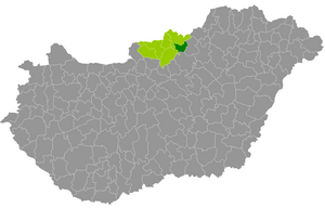
Bátonyterenye District
Districts of Hungary in Nógrád
Distance: Approx. 3778 meters
Latitude and longitude: 48,19.85
Bátonyterenye (Hungarian: Bátonyterenyei járás) is a district in eastern part of Nógrád County. Bátonyterenye is also the name of the town where the district seat is found. The district is located in the Northern Hungary Statistical Region.
Weather in this IP's area
light rain
4 Celsius
4 Celsius
2 Celsius
4 Celsius
1028 hPa
77 %
1028 hPa
995 hPa
10000 meters
0.65 m/s
0.66 m/s
76 degree
22 %
06:39:32
16:09:18