Country:
Region:
City:
Latitude and Longitude:
Time Zone:
Postal Code:
IP information under different IP Channel
ip-api
Country
Region
City
ASN
Time Zone
ISP
Blacklist
Proxy
Latitude
Longitude
Postal
Route
Luminati
Country
Region
22
City
sofia
ASN
Time Zone
Europe/Sofia
ISP
A1 Bulgaria EAD
Latitude
Longitude
Postal
IPinfo
Country
Region
City
ASN
Time Zone
ISP
Blacklist
Proxy
Latitude
Longitude
Postal
Route
db-ip
Country
Region
City
ASN
Time Zone
ISP
Blacklist
Proxy
Latitude
Longitude
Postal
Route
ipdata
Country
Region
City
ASN
Time Zone
ISP
Blacklist
Proxy
Latitude
Longitude
Postal
Route
Popular places and events near this IP address
Bulgarian National Bank
Central bank of Bulgaria
Distance: Approx. 145 meters
Latitude and longitude: 42.69638889,23.32527778
The Bulgarian National Bank (Bulgarian: Българска народна банка, romanized: Bulgarska narodna banka, IPA: [ˈbɤɫɡɐrskɐ nɐˈrɔdnɐ ˈbaŋkɐ], BNB) is the central bank of the Republic of Bulgaria. It has also been Bulgaria's national competent authority within European Banking Supervision since 2020. Headquartered in Sofia, the bank was established in 1879.

Ivan Vazov National Theatre
Distance: Approx. 154 meters
Latitude and longitude: 42.69416667,23.32638889
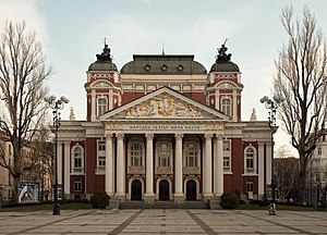
The Ivan Vazov National Theatre (Bulgarian: Народен театър „Иван Вазов“, Naroden teatar „Ivan Vazov“) is Bulgaria's national theatre, as well as the oldest and most authoritative theatre in the country and one of the important landmarks of Sofia, the capital of Bulgaria. It is located in the centre of the city, with the facade facing the City Garden. The Ivan Vazov National Theatre has a well-equipped main stage with 750 seats, a smaller 120-seat stage and an additional 70-seat one on the fourth floor.
Church of Saint George, Sofia
Red brick rotunda in Sofia, Bulgaria
Distance: Approx. 263 meters
Latitude and longitude: 42.696875,23.322875
The Church of Saint George (Bulgarian: Ротонда „Свети Георги“, romanized: Rotonda "Sveti Georgi") is a Late Antique red brick rotunda in Sofia, Bulgaria. Built in the early 4th century as Roman baths, it became a church inside the walls of Serdica, capital of ancient Dacia Mediterranea during the Roman Empire and Byzantine Empire. The Early Christian church is considered the oldest building in modern Sofia and belongs to the Bulgarian Orthodox Church.

Prince Alexander of Battenberg Square
Distance: Approx. 160 meters
Latitude and longitude: 42.69611111,23.32638889
Prince Alexander I Square (Bulgarian: площад Княз Александър I, Ploshtad Knyaz Aleksandar I), often called simply Battenberg Square (площад Батенберг) is the largest square of Sofia, the capital of Bulgaria. It is named after Alexander Joseph of Battenberg (Alexander I of Bulgaria), the first prince of modern Bulgaria. During the Communist rule of Bulgaria, the square was named September 9th Square, after a coup on September 9, 1944, made the country a Communist state.

Georgi Dimitrov Mausoleum
Former tomb in Sofia, Bulgaria
Distance: Approx. 122 meters
Latitude and longitude: 42.69583333,23.32611111
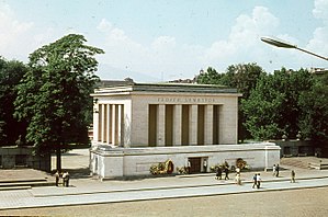
The Georgi Dimitrov Mausoleum (Bulgarian: мавзолей на Георги Димитров) was a ceremonial tomb on Prince Alexander of Battenberg Square in Sofia, Bulgaria. It was built in 1949 to house the embalmed body of Georgi Dimitrov, the first leader of Communist Bulgaria. After his death in 1950, the second communist leader of Bulgaria, Vasil Kolarov, was buried in the second niche of the east wall of the mausoleum.

National Art Gallery, Bulgaria
Art museum in Sofia, Bulgaria
Distance: Approx. 212 meters
Latitude and longitude: 42.69648111,23.32678611
The National Art Gallery (Bulgarian: Национална художествена галерия, Natsionalna hudozhestvena galeriya) is Bulgaria's national gallery, and houses over 50,000 pieces of Bulgarian art.

National Archaeological Museum, Bulgaria
Archaeological museum and research institute in Sofia, Bulgaria
Distance: Approx. 142 meters
Latitude and longitude: 42.69633056,23.32456389
The National Archaeological Museum (Bulgarian: Национален археологически музей, Natsionalen arheologicheski muzey) is an archaeological museum in the centre of Sofia, the capital of Bulgaria. It occupies the building of the largest and oldest former Ottoman mosque in the city, originally known as Koca Mahmut Paşa Camii. The construction started in 1451 under grand vizier Veli Mahmud Pasha but due to his death in 1474 the mosque has been completed in 1494.

City Garden (Sofia)
Public garden in Sofia, Bulgaria
Distance: Approx. 25 meters
Latitude and longitude: 42.695,23.32527778
The City Garden (Bulgarian: Градска градина, Gradska gradina) is Sofia, the capital of Bulgaria's oldest and most central public garden, in existence since 1872. It is located between Tsar Osvoboditel Boulevard to the north, Knyaz Alexander Battenberg Street to the west and Joseph Vladimirovich Gourko Street to the south, in the historical centre of the city. Originally arranged in the last years of the Ottoman rule of Bulgaria, it was radically transformed immediately after the Liberation of Bulgaria in 1878 and the choice of Sofia as the capital the following year under the city architect Antonín Kolář on the initiative of the temporary governor Pyotr Alabin.

Georgi Rakovski Street
Distance: Approx. 297 meters
Latitude and longitude: 42.69341389,23.32781667
Georgi Rakovski Street (Bulgarian: Улица Георги Раковски, Ulitsa Georgi Rakovski), usually called with its old name Rakovska, is an important street in the capital of Bulgaria, Sofia, located in the central area of the city. It is named after the famous Bulgarian revolutionary Georgi Sava Rakovski. It lies between the Slivnitsa Boulevard to the north and Evlogi Georgiev Boulevard to the south.

Church of St. Nicholas, Sofia
Distance: Approx. 201 meters
Latitude and longitude: 42.69596,23.32284
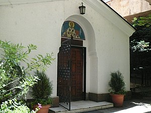
The Church of St. Nicholas (Bulgarian: Свети Николай Мирликийски чудотворец) is an Eastern Orthodox Church in the Bulgarian capital of Sofia. The church was built in the 13th century by Kaloyan the sebastocrator as a small family church on today's Kaloyan Street behind the Rila Hotel.
Stolichna Municipality
Municipality of Bulgaria
Distance: Approx. 301 meters
Latitude and longitude: 42.6976,23.3236
The Stolichna Municipality (Bulgarian: Столична община, romanized: Stolichna obshtina (also transcribed as Stolična obština), lit. 'Capital Municipality') is an obshtina (municipality) in Sofia City Province, Western Bulgaria. It is named after its administrative centre, the city of Sofia, which is also the capital of Sofia City Province and Sofia Province and the capital of Bulgaria as well. The municipality is located mainly in the Sofia Valley, and also in the foots and lower parts of the mountains of Stara planina and Vitosha, Plana, Lozen, Rila.

Royal Palace (Sofia)
Former Royal Palace in Sofia, Bulgaria
Distance: Approx. 218 meters
Latitude and longitude: 42.6963,23.3271
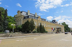
The Royal Palace, in fact called Prince's Palace (Bulgarian: Княжески дворец – Knyazheski dvorets) and later Tsar's Palace (Bulgarian: Царски дворец – Tsarski dvorets), is an architectural landmark of national historical and cultural significance, situated at Battenberg Square in the heart of Sofia, the capital of Bulgaria. The palace have witnessed the country's journey through monarchy and people's republic towards today republic democracy as its inhabitants have played a pivotal role in the history of Bulgaria. Erected in the late 19th century as the royal residence, the palace's architecture blends various styles, with prominent influences from Austrian Neo-Baroque and French Rococo.
Weather in this IP's area
clear sky
7 Celsius
6 Celsius
6 Celsius
7 Celsius
1029 hPa
63 %
1029 hPa
962 hPa
10000 meters
1.35 m/s
2 m/s
301 degree
10 %
07:05:55
17:14:40

