Country:
 Bulgaria
Region:
City:
Latitude and Longitude:
Time Zone:
Postal Code:
IP information under different IP Channel
ip-api
Country
Region
City
ASN
Time Zone
ISP
Blacklist
Proxy
Latitude
Longitude
Postal
Route
IPinfo
Country
Region
City
ASN
Time Zone
ISP
Blacklist
Proxy
Latitude
Longitude
Postal
Route
MaxMind
Country
Region
City
ASN
Time Zone
ISP
Blacklist
Proxy
Latitude
Longitude
Postal
Route
Luminati
Country
BGRegion
10
City
kyustendil
ASN
Time Zone
Europe/Sofia
ISP
A1 Bulgaria EAD
Latitude
Longitude
Postal
db-ip
Country
Region
City
ASN
Time Zone
ISP
Blacklist
Proxy
Latitude
Longitude
Postal
Route
ipdata
Country
Region
City
ASN
Time Zone
ISP
Blacklist
Proxy
Latitude
Longitude
Postal
Route
Popular places and events near this IP address

Kyustendil
Town in Bulgaria
Distance: Approx. 1089 meters
Latitude and longitude: 42.28333333,22.68333333
Kyustendil (Bulgarian: Кюстендил [kʲustenˈdiɫ]) is a town in the far west of Bulgaria, the capital of the Kyustendil Province, a former bishopric and present Latin Catholic titular see. The town is situated in the southern part of the Kyustendil Valley, near the borders of Serbia and North Macedonia; 90 km southwest of Sofia, 130 km northeast of Skopje and 243 km north of Thessaloniki. The population is 37 799, with a Bulgarian majority and a Roma minority.

Granitsa, Kyustendil Province
Place in Kyustendil, Bulgaria
Distance: Approx. 5219 meters
Latitude and longitude: 42.25,22.73333333
Granitsa (Bulgarian: Граница, pronounced [ɡrɐˈnit͡sɐ]; also transliterated Granica or Granitza) is a village in southwestern Bulgaria, part of Kyustendil Municipality, Kyustendil Province. Granitsa lies in a hilly valley in the eastern Osogovo mountains. It is bisected by a ravine, the bed of a rivulet which goes almost dry in the summer and autumn.

Church of St George, Kyustendil
Distance: Approx. 2413 meters
Latitude and longitude: 42.27061389,22.67693611
The Church of St George (Bulgarian: църква „Свети Георги“, tsarkva „Sveti Georgi“) is a medieval Eastern Orthodox church in the city of Kyustendil, which lies in southwestern Bulgaria and is the administrative capital of Kyustendil Province. The church is located in the Kolusha neighbourhood, which was historically separate from the city. The church was constructed in the 10th–11th century and its frescoes are somewhat later, as the earliest layers were painted in the 11th–12th century.

Bogoslov
Village in Kyustendil, Bulgaria; notable for Velin Alaykov
Distance: Approx. 4289 meters
Latitude and longitude: 42.25,22.68333333
Bogoslov is a village in Kyustendil Municipality, Kyustendil Province, Bulgaria. Notable people include Velin Alaykov.

Kyustendil Municipality
Municipality in Kyustendil, Bulgaria
Distance: Approx. 1089 meters
Latitude and longitude: 42.28333333,22.68333333
Kyustendil Municipality is a municipality in Kyustendil Province, Bulgaria. The administrative centre is Kyustendil.
Gramazhdano
Village in Kyustendil Province, Bulgaria
Distance: Approx. 4784 meters
Latitude and longitude: 42.2606,22.65
Gramazhdano is a village in Kyustendil Municipality, Kyustendil Province, south-western Bulgaria.
Nikolichevtsi
Village in Kyustendil Province, Bulgaria
Distance: Approx. 4268 meters
Latitude and longitude: 42.3242,22.7103
Nikolichevtsi is a village in Kyustendil Municipality, Kyustendil Province, south-western Bulgaria.
Piperkov Chiflik
Village in Kyustendil Province, Bulgaria
Distance: Approx. 3884 meters
Latitude and longitude: 42.2742,22.7389
Piperkov Chiflik is a village in Kyustendil Municipality, Kyustendil Province, south-western Bulgaria.
Skrinyano
Village in Kyustendil Province, Bulgaria
Distance: Approx. 3503 meters
Latitude and longitude: 42.3189,22.6981
Skrinyano is a village in Kyustendil Municipality, Kyustendil Province, south-western Bulgaria.
Slokostitsa
Village in Kyustendil Province, Bulgaria
Distance: Approx. 2514 meters
Latitude and longitude: 42.2667,22.7072
Slokoshtitsa is a village in Kyustendil Municipality, Kyustendil Province, south-western Bulgaria.

Zhilentsi
Village in Kyustendil Province, Bulgaria
Distance: Approx. 4391 meters
Latitude and longitude: 42.2667,22.65
Zhilentsi is a village in Kyustendil Municipality, Kyustendil Province, south-western Bulgaria.
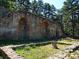
Hisarlaka fortress
Late Antiquity and medieval fortress
Distance: Approx. 1341 meters
Latitude and longitude: 42.2758,22.6914
Hisarlaka Fortress is an ancient and medieval fortress occupying a hill at 2 kilometres (1.2 mi) to the south-east of Kyustendil, in what is now Bulgaria. Originally constructed by the Romans around 400 AD, it was among the most important castles of the Bulgarian Empire in the Middle Ages before it was partially destroyed by the Ottomans in the 15th century. Hisarlaka Fortress was the administrative and religious center of the region from the 5th to the 15th centuries.
Weather in this IP's area
scattered clouds
13 Celsius
12 Celsius
13 Celsius
13 Celsius
1015 hPa
74 %
1015 hPa
955 hPa
10000 meters
1.09 m/s
1.29 m/s
314 degree
44 %
07:11:32
19:35:55