87.197.174.117 - IP Lookup: Free IP Address Lookup, Postal Code Lookup, IP Location Lookup, IP ASN, Public IP
Country:
Region:
City:
Location:
Time Zone:
Postal Code:
IP information under different IP Channel
ip-api
Country
Region
City
ASN
Time Zone
ISP
Blacklist
Proxy
Latitude
Longitude
Postal
Route
Luminati
Country
Region
bl
City
bratislava
ASN
Time Zone
Europe/Bratislava
ISP
Slovak Telekom, a.s.
Latitude
Longitude
Postal
IPinfo
Country
Region
City
ASN
Time Zone
ISP
Blacklist
Proxy
Latitude
Longitude
Postal
Route
IP2Location
87.197.174.117Country
Region
presovsky kraj
City
strba
Time Zone
Europe/Bratislava
ISP
Language
User-Agent
Latitude
Longitude
Postal
db-ip
Country
Region
City
ASN
Time Zone
ISP
Blacklist
Proxy
Latitude
Longitude
Postal
Route
ipdata
Country
Region
City
ASN
Time Zone
ISP
Blacklist
Proxy
Latitude
Longitude
Postal
Route
Popular places and events near this IP address
Kozie chrbty
Distance: Approx. 6957 meters
Latitude and longitude: 49.03333333,20.16666667
The Kozie chrbty (In Slovak, literally "goat ridges") are a mountainous area in Slovakia, part of the Fatra-Tatra Area of the Inner Western Carpathians, where uranium ore may be found. The place was previously known as Vikartovský ridge. The Kozie chrbty is located between the High Tatras and the Low Tatras, south and west of Poprad.

Štrbské Pleso
Distance: Approx. 6479 meters
Latitude and longitude: 49.11666667,20.06666667
Štrbské Pleso (, German: Tschirmer See; Hungarian: Csorbató or Csorba-tó; Polish: Szczyrbskie Jezioro) is a ski, tourist, and health resort in the High Tatras, Slovakia located on the lake by the same name. With extensive parking facilities and a stop on the Tatra trolley and rack railway, it is a starting point for a host of popular hikes including to Kriváň and Rysy.

Štrbské Pleso–Štrba rack railway
Railway in Slovakia
Distance: Approx. 2949 meters
Latitude and longitude: 49.08388889,20.06555556
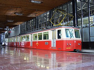
The Štrbské Pleso–Štrba rack railway is a 1,000 mm (3 ft 3+3⁄8 in) gauge narrow-gauge railway in the High Tatras. It was built in 1896 and reconstructed in 1970. At the valley terminus (Štrba railway station), it connects to the standard-gauge main line between Bratislava and Košice, and at the mountain terminus (Štrbské Pleso railway station), it connects to the Tatra Electric Railway.
Štrba
Municipality in Prešov, Slovakia
Distance: Approx. 1276 meters
Latitude and longitude: 49.06666667,20.06666667
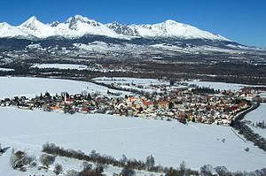
Štrba (Hungarian: Csorba, German: Tschirm) is a village in the Poprad District, Prešov Region, northern Slovakia. It is situated in the Sub-Tatra Basin, which separates the High Tatras and Low Tatras at the European continental divide between the Baltic and the Black Sea. It is approximately 16 km (9.9 mi) west of the city of Poprad.
Lučivná
Municipality in Slovakia
Distance: Approx. 4658 meters
Latitude and longitude: 49.05222222,20.14277778
Lučivná (Hungarian: Lucsivna) is a village and municipality in Poprad District in the Prešov Region of northern Slovakia. It lies on the foothills oh High Tatras. It is a small spa village.

Mengusovce
Municipality in Slovakia
Distance: Approx. 4787 meters
Latitude and longitude: 49.07444444,20.14111111
Mengusovce (Hungarian: Menguszfalva) is a village and municipality in Poprad District in the Prešov Region of northern Slovakia. It lies on the foothills of High Tatras.
Šuňava
Municipality in Slovakia
Distance: Approx. 3295 meters
Latitude and longitude: 49.03,20.08805556
Šuňava (Hungarian: Szépfalu, German: Schönau) is a village and municipality in Poprad District in the Prešov Region of northern Slovakia.
Štôla
Municipality in Slovakia
Distance: Approx. 5830 meters
Latitude and longitude: 49.0925,20.14138889
Štôla (Hungarian: Stóla, German: Stollen) is a village and small municipality in Poprad District in the Prešov Region of northern Slovakia. It lies on the foothills of High Tatras.

Lučivná Tunnel
Tunnel in Slovakia
Distance: Approx. 2219 meters
Latitude and longitude: 49.07150278,20.103625
The Lučivná Tunnel is a short covered tunnel in northern Slovakia, on the D1 motorway between Štrba and Mengusovce. Its construction started in 2005 and was open in 2007. Its purpose is to provide a safe crossing for wild animals.

Podtatranská kotlina
Distance: Approx. 6399 meters
Latitude and longitude: 49.083,20
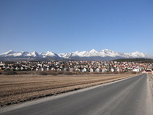
The Podtatranská kotlina (literally Sub-Tatra Basin or Basin under Tatra(s)) is a basin in northern Slovakia, part of the Fatra-Tatra Area, which belongs to the Inner Western Carpathians. Towns and cities include Ružomberok, Liptovský Mikuláš, Liptovský Hrádok, Svit, Poprad, Kežmarok, Spišská Belá and Podolínec.

Štrbské Pleso railway station
Railway station in Štrbské Pleso, Slovakia
Distance: Approx. 6706 meters
Latitude and longitude: 49.11833333,20.06305556
Štrbské Pleso railway station (Slovak: Železničná stanica Štrbské Pleso) is a junction station in the High Tatras. It serves the settlement of Štrbské Pleso, which is part of the village of Štrba, in the Prešov Region, northeastern Slovakia. Opened in 1970, the station is the northwestern terminus of the main line operated by the metre gauge Tatra Electric Railway (TEŽ), and the mountain terminus of the Štrbské Pleso – Štrba rack railway, another metre gauge line.

Štrba railway station
Railway station in Slovakia
Distance: Approx. 2949 meters
Latitude and longitude: 49.08388889,20.06555556
Štrba railway station (Hungarian: Csorba vasútállomás; Slovak: Železničná stanica Štrba) is a break-of-gauge junction station serving the village of Štrba, in the Prešov Region, northeastern Slovakia. The station forms part of the standard gauge Košice–Bohumín Railway (KBD), and is the highest point on that line. It is also the junction between the KBD and the Štrbské Pleso – Štrba rack railway, a metre gauge line of which it is the valley terminus.
Weather in this IP's area
fog
-8 Celsius
-8 Celsius
-8 Celsius
-8 Celsius
1029 hPa
93 %
1029 hPa
925 hPa
150 meters
0.51 m/s
100 %

