Country:
 Portugal
Region:
City:
Latitude and Longitude:
Time Zone:
Postal Code:
IP information under different IP Channel
ip-api
Country
Region
City
ASN
Time Zone
ISP
Blacklist
Proxy
Latitude
Longitude
Postal
Route
IPinfo
Country
Region
City
ASN
Time Zone
ISP
Blacklist
Proxy
Latitude
Longitude
Postal
Route
MaxMind
Country
Region
City
ASN
Time Zone
ISP
Blacklist
Proxy
Latitude
Longitude
Postal
Route
Luminati
Country
PTRegion
03
City
prazins
ASN
Time Zone
Europe/Lisbon
ISP
Nos Comunicacoes, S.A.
Latitude
Longitude
Postal
db-ip
Country
Region
City
ASN
Time Zone
ISP
Blacklist
Proxy
Latitude
Longitude
Postal
Route
ipdata
Country
Region
City
ASN
Time Zone
ISP
Blacklist
Proxy
Latitude
Longitude
Postal
Route
Popular places and events near this IP address
S.C. Braga
Portuguese professional football club
Distance: Approx. 3266 meters
Latitude and longitude: 41.5625,-8.43083333
Sporting Clube de Braga (Portuguese pronunciation: [ˈspɔɾtĩ ˈkluβɨ ðɨ ˈβɾaɣɐ]) (Euronext Lisbon: SCB ), commonly known as Sporting de Braga or just Braga, is a Portuguese sports club from the city of Braga. Best known for the men's professional football team playing in the Primeira Liga, the top flight of Portuguese football at the Estádio Municipal de Braga, it also has departments for athletics, badminton, basketball, beach soccer, billiards, boccia, boxing, esports, futsal, karate, kickboxing, muay thai, swimming, taekwondo and volleyball. Founded on 19 January 1921, Braga are nicknamed, Braguistas, and Os Arsenalistas (The Arsenalists) for the shirt colour that resembles English club Arsenal.
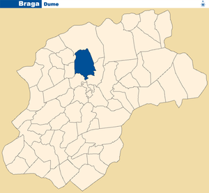
Dume
Civil parish in Norte, Portugal
Distance: Approx. 2447 meters
Latitude and longitude: 41.571,-8.434
Dume is a former freguesia ("civil parish") and former bishopric in the municipality of Braga, northern Portugal, which remains a Catholic titular see. In 2013, the parish merged into the new parish Real, Dume e Semelhe. It has a population of 3,081 and a total area of 4.34 square kilometres (1.68 sq mi).

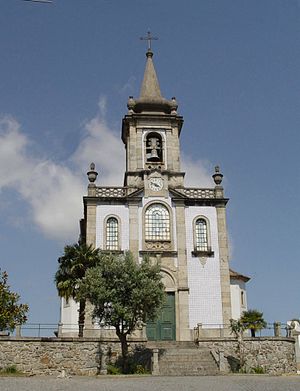
Monastery of Dumio
Distance: Approx. 2894 meters
Latitude and longitude: 41.56713333,-8.43556389
The Monastery of Dumio (sometimes Dumium or Dumio, in Portuguese São Martinho de Dume), is a former paleo-Christian monastery in the civil parish of Dume, municipality of Braga, in northwestern Portugal. Originally a Roman villa, it was the base of a basilica by Suebi tribes, and later Christian monastery headed by Martin of Braga in the 6th century (c. 550–560).
Adaúfe
Civil parish in Norte, Portugal
Distance: Approx. 1806 meters
Latitude and longitude: 41.585,-8.402
Adaúfe is a Portuguese freguesia ("civil parish"), located in the municipality of Braga. The population in 2011 was 3,711, in an area of 10.81 km2.
Merelim (São Pedro) e Frossos
Civil parish in Norte, Portugal
Distance: Approx. 2885 meters
Latitude and longitude: 41.578,-8.452
Merelim (São Pedro) e Frossos is a civil parish in the municipality of Braga, Portugal. It was formed in 2013 by the merger of the former parishes Merelim (São Pedro) and Frossos. The population in 2011 was 3,726, in an area of 3.15 km².
Palmeira (Braga)
Civil parish in Norte, Portugal
Distance: Approx. 659 meters
Latitude and longitude: 41.594,-8.429
Palmeira is a Portuguese parish, located in the municipality of Braga. The population in 2011 was 5,468, in an area of 8.88 km². It is located near the Cávado river, on the south bank, about 5 mi (8.0 km) north from the historic center of the city of Braga.

Sete Fontes (Braga)
Water supply in Braga, Portugal
Distance: Approx. 2845 meters
Latitude and longitude: 41.56948889,-8.40386111
The Sete Fontes (literally 'Seven Springs') is part of a large water supply system built in mid-18th century, that supplied potable water to the northern Portuguese municipality of Braga, until the first half of the 20th century. In reality, there are only six springs from this network that still exist, following destruction of one in the early 1990s, to allow the construction of residential homes. The remaining sections of the Sete Fontes are identifiable for the springs that are housed within their respective Mãe de aguas ('mother of waters'), which are connected via aqueducts running along the surface or through tunnels, known as minas ('mines').

Castelo da Dona Chica
Manor house (Solar) in Braga, Portugal
Distance: Approx. 568 meters
Latitude and longitude: 41.58878889,-8.42818611
The Castle of Dona Chica (Portuguese: Castelo da Dona Chica) is a neo-romantic castle and/or residence located in the civil parish of Palmeira, municipality of Braga, in the northern region of Portugal. Originally designed by Ernesto Korrodi, the project suffered from a lack of funds early, eventually changing hands and falling into the possession of creditors.
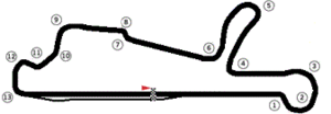
Circuito Vasco Sameiro
Distance: Approx. 1976 meters
Latitude and longitude: 41.58636944,-8.44496944
The Circuito de Velocidade Vasco Sameiro (also known as Circuit of Braga) is a racing circuit located 6 km (3.7 mi) north of Braga, Portugal at Palmeira. It was constructed in 1990 around the local aerodrome and is 3.021 km (1.877 mi) long. The track runs in an anticlockwise direction.
Lago (Amares)
Civil parish in Norte, Portugal
Distance: Approx. 2139 meters
Latitude and longitude: 41.6103,-8.4231
Lago is a parish in Amares Municipality in the Braga District in Portugal. The population in 2011 was 1,910, in an area of 3.99 km².

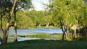
Ponte do Bico
Crossing of the River Cávado, Braga District, Portugal
Distance: Approx. 1808 meters
Latitude and longitude: 41.60638889,-8.42944444
Ponte do Bico is a bridge in Portugal. It is located in Braga District, crossing the Cávado River. It is a work from the time of minister Fontes Pereira de Melo who is mostly remembered for conducting dynamic industrial and public infrastructure policy which become known as Fontismo (after his name).
Braga Airport
Airport in Palmeira
Distance: Approx. 1962 meters
Latitude and longitude: 41.58694444,-8.445
Braga Airport (IATA: BGZ, ICAO: LPBR) is an airport in Palmeira, 3 km (1.9 mi) north northwest of Braga, Portugal.
Weather in this IP's area
overcast clouds
20 Celsius
20 Celsius
19 Celsius
20 Celsius
1020 hPa
88 %
1020 hPa
1011 hPa
10000 meters
1.06 m/s
1.21 m/s
238 degree
100 %
07:29:37
19:17:22