87.120.248.189 - IP Lookup: Free IP Address Lookup, Postal Code Lookup, IP Location Lookup, IP ASN, Public IP
Country:
 Ireland
Region:
City:
Location:
Time Zone:
Postal Code:
ISP:
ASN:
language:
User-Agent:
Proxy IP:
Blacklist:
IP information under different IP Channel
ip-api
Country
Region
City
ASN
Time Zone
ISP
Blacklist
Proxy
Latitude
Longitude
Postal
Route
db-ip
Country
Region
City
ASN
Time Zone
ISP
Blacklist
Proxy
Latitude
Longitude
Postal
Route
IPinfo
Country
Region
City
ASN
Time Zone
ISP
Blacklist
Proxy
Latitude
Longitude
Postal
Route
IP2Location
87.120.248.189Country
ieRegion
meath
City
dunboyne
Time Zone
Europe/Dublin
ISP
Language
User-Agent
Latitude
Longitude
Postal
ipdata
Country
Region
City
ASN
Time Zone
ISP
Blacklist
Proxy
Latitude
Longitude
Postal
Route
Popular places and events near this IP address

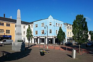
Dunboyne
Town near Dublin, Ireland
Distance: Approx. 2292 meters
Latitude and longitude: 53.42,-6.475
Dunboyne (Irish: Dún Búinne, meaning 'Búinne's stronghold') is a town in County Meath, Ireland, 15 km (9 mi) north-west of Dublin city centre. It is a commuter town for Dublin. In the 20 years between the 1996 and 2016 censuses, the population of Dunboyne more than doubled from 3,080 to 7,272 inhabitants.

Confey GAA
Irish Gaelic Athletic Association club
Distance: Approx. 2994 meters
Latitude and longitude: 53.374829,-6.482706
Confey GAA is a Gaelic Athletic Association (GAA) club based in Leixlip, County Kildare, Ireland, and won Kildare's Club of the Year award in 2004.

Leixlip Confey railway station
Railway station in Leixlip, Ireland
Distance: Approx. 3139 meters
Latitude and longitude: 53.3741,-6.4855
Leixlip Confey is a railway station in the north-eastern corner of County Kildare, Ireland. It is one of two stations that serve the civil parish of Leixlip, the other being Leixlip Louisa Bridge. Both stations lie on the Dublin to Maynooth commuter route.

Clonsilla railway station
Station in suburbs of Dublin, Ireland
Distance: Approx. 3469 meters
Latitude and longitude: 53.383,-6.423
Clonsilla railway station is a railway station that serves Clonsilla, in Fingal, Ireland.
Ongar, Dublin
Outer residential suburb of Dublin, Ireland
Distance: Approx. 1861 meters
Latitude and longitude: 53.395805,-6.439654
Ongar is a western suburb of Dublin, Ireland. Developed on a greenfield basis since 2001, it comprises the townlands of Castaheany (northerly) and "Hansfield or Phibblestown" (southerly), within the ancient Barony of Castleknock, County Dublin. It is close to Castleknock, Blanchardstown and Clonsilla.

Clonee
Village in County Meath, west of Dublin, Ireland
Distance: Approx. 1986 meters
Latitude and longitude: 53.4117,-6.4442
Clonee (Irish: Cluain Aodha, meaning 'Aodh's pasture') is a village and a townland in County Meath, Ireland. It borders County Dublin to the east at the townlands of Huntstown and Littlepace, and is sometimes used in addresses for housing in those townlands. The River Tolka passes the village.

Garda GAA
Gaelic games club in County Dublin, Ireland
Distance: Approx. 2921 meters
Latitude and longitude: 53.37621111,-6.44823611
Garda GAA is a Gaelic Athletic Association club based in Dublin, Republic of Ireland, founded in 1922. They are the GAA representative team of the Garda Síochána. Garda have won the Dublin Senior Football Championship on six occasions in 1927, 1929, 1933, 1934, 1935 and 1948.
Erin go Bragh GAA
Dublin-based Gaelic Athletic Association club
Distance: Approx. 2580 meters
Latitude and longitude: 53.40112778,-6.427975
Erin go Bragh GAA are a Dublin-based Gaelic Athletic Association club based in Clonee, Littlepace/Castaheaney/Ongar district in Dublin 15. The club currently fields one team in junior football (AFL 8 and Junior 2 Championship), one junior hurling team (AHL 8 and Junior F Championship) and one Ladies Gaelic Football team. They also have a boys and girls juvenile section fielding from Under 8-minor in football, hurling and camogie.
Hansfield railway station
Station near Dublin, Ireland
Distance: Approx. 2180 meters
Latitude and longitude: 53.3871,-6.4421
Hansfield railway station is a railway station in County Dublin, Ireland. It lies on the Docklands to M3 Parkway Commuter service and serves housing estates including Hansfield, Ongar, Littlepace, and Barnwell, among others; it is also the station nearest Clonee.

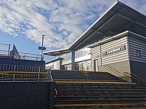
Dunboyne railway station
Railway station in Dunboyne, Ireland
Distance: Approx. 1891 meters
Latitude and longitude: 53.41694444,-6.46472222
Dunboyne railway station is a railway station serving the town of Dunboyne in County Meath, Ireland. Dunboyne station features car parking for up to 300 cars, operated by APCOA Parking, enabling it to serve as a small park & ride stop for commuters to Dublin.
R157 road (Ireland)
Road in Ireland
Distance: Approx. 3625 meters
Latitude and longitude: 53.408099,-6.519699
The R157 is a Regional road between Dunboyne and Maynooth in Ireland. It connects to the M3 motorway (Blanchardstown to Kells). This route runs in Counties Kildare and Meath.

Hartstown Community School
Secondary school in Republic of Ireland
Distance: Approx. 3404 meters
Latitude and longitude: 53.3961,-6.41594
Hartstown Community School is an Irish Secondary School located in Hartstown, Clonsilla. It serves the area of Hartstown, Huntstown and other localities in the Clonsilla suburb. Hartstown / Huntstown Community School is a co-educational, multi-denominational Community School founded in 1992 to cater for the educational needs of Hartstown & Huntstown 2nd level pupils.
Weather in this IP's area
broken clouds
8 Celsius
4 Celsius
7 Celsius
9 Celsius
1014 hPa
85 %
1014 hPa
1000 hPa
10000 meters
11.83 m/s
180 degree
75 %