87.120.241.106 - IP Lookup: Free IP Address Lookup, Postal Code Lookup, IP Location Lookup, IP ASN, Public IP
Country:
Region:
City:
Location:
Time Zone:
Postal Code:
ISP:
ASN:
language:
User-Agent:
Proxy IP:
Blacklist:
IP information under different IP Channel
ip-api
Country
Region
City
ASN
Time Zone
ISP
Blacklist
Proxy
Latitude
Longitude
Postal
Route
db-ip
Country
Region
City
ASN
Time Zone
ISP
Blacklist
Proxy
Latitude
Longitude
Postal
Route
IPinfo
Country
Region
City
ASN
Time Zone
ISP
Blacklist
Proxy
Latitude
Longitude
Postal
Route
IP2Location
87.120.241.106Country
Region
monaghan
City
monaghan
Time Zone
Europe/Dublin
ISP
Language
User-Agent
Latitude
Longitude
Postal
ipdata
Country
Region
City
ASN
Time Zone
ISP
Blacklist
Proxy
Latitude
Longitude
Postal
Route
Popular places and events near this IP address

Monaghan
Town in County Monaghan, Ireland
Distance: Approx. 365 meters
Latitude and longitude: 54.24777778,-6.97083333
Monaghan ( MON-ə-hən; Irish: Muineachán [ˈmˠɪnʲəxaːnˠ]) is the county town of County Monaghan, Ireland. It also provides the name of its civil parish and Monaghan barony. The population of the town as of the 2022 census was 7,894.
Roman Catholic Diocese of Clogher
Catholic diocese in Ireland
Distance: Approx. 817 meters
Latitude and longitude: 54.2447,-6.958
The Diocese of Clogher (Latin: Dioecesis Clogheriensis, Irish: Deoise Chlochair; , ) is a Latin Church diocese of the Catholic Church in Ireland. It was formed in 1111 at the Synod of Rathbreasail as the see for the Kingdom of Uí Chremthainn. It is part of the Province of Armagh.

Monaghan Hospital
Hospital in the town of Monaghan, County Monaghan, Ireland
Distance: Approx. 501 meters
Latitude and longitude: 54.2502,-6.9744
Monaghan General Hospital (Irish: Ospidéal Mhuineacháin) is a hospital in the town of Monaghan, County Monaghan, Ireland.

Harvest Time Blues
Annual music festival, Monaghan, Ireland
Distance: Approx. 355 meters
Latitude and longitude: 54.2479,-6.9708
Harvest Time Blues (also referred to as the Monaghan Rhythm and Blues Festival) is an annual music festival held in Monaghan town, in Ireland. Since its launch in 1990, it has been described as "one of Ireland's leading live music festivals". Performers appearing at the festival have included Van Morrison, Peter Green of Fleetwood Mac, and ex-The Rolling Stones guitarist Mick Taylor.

Rossmore Forest Park
Park on the Cavan-Monaghan county border, Ireland
Distance: Approx. 3144 meters
Latitude and longitude: 54.228,-6.997
Rossmore Forest Park is a national forest park located in County Monaghan in Ireland run by the Irish States forestry organisation, Coillte. It is situated approximately 5km outside Monaghan town and has its main entrance on the R189 Threemilehouse/Newbliss Road.

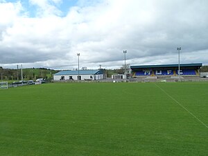
Gortakeegan
Soccer venue in Monaghan, Ireland
Distance: Approx. 1859 meters
Latitude and longitude: 54.2333,-6.9667
Gortakeegan (Irish: Gort an Chaocháin ) is an association football venue in the Republic of Ireland based in Monaghan. It has been the home ground of former League of Ireland club Monaghan United since 1988. The ground has an 528-seater covered stand and an overall capacity of 5,000.
St Macartan's Cathedral, Monaghan
Church in Monaghan, Ireland
Distance: Approx. 824 meters
Latitude and longitude: 54.24444444,-6.95833333
St Macartan's Cathedral is the cathedral church of the Roman Catholic Diocese of Clogher in Ireland. It is located in the townland of Latlurcan, Monaghan town in the ecclesiastical parish of Monaghan and Rackwallace. It was built between the years of 1861 and 1893 and is the only cathedral in the county.

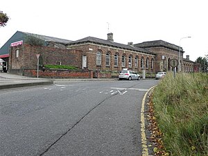
Monaghan railway station
Disused railway station in Ireland
Distance: Approx. 453 meters
Latitude and longitude: 54.246,-6.968
Monaghan railway station was on the Ulster Railway designed by Sir John Macneil located in the Republic of Ireland.

Monaghan County Museum
County museum in Monaghan, Ireland
Distance: Approx. 448 meters
Latitude and longitude: 54.24784,-6.97252
Monaghan County Museum (Irish: Músaem Chontae Mhuineacháin) is a museum which documents the history of County Monaghan.

St. Davnet's Hospital
Psychiatric hospital in County Monaghan, Ireland
Distance: Approx. 564 meters
Latitude and longitude: 54.251,-6.9582
St. Davnet's Hospital (Irish: Ospidéal Naomh Damhnait) is a psychiatric hospital in Monaghan, County Monaghan, Ireland.

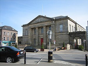
Monaghan Courthouse
Building in County Monaghan, Ireland
Distance: Approx. 347 meters
Latitude and longitude: 54.2476,-6.9701
Monaghan Courthouse is a judicial facility in Monaghan, County Monaghan, Ireland
County Offices, Monaghan
Municipal building in County Monaghan, Ireland
Distance: Approx. 900 meters
Latitude and longitude: 54.2424,-6.9714
The County Offices (Irish: Oifigí an Chontae, Muineachán) is a municipal facility at Monaghan, County Monaghan, Ireland.
Weather in this IP's area
scattered clouds
2 Celsius
0 Celsius
2 Celsius
2 Celsius
1005 hPa
95 %
1005 hPa
991 hPa
10000 meters
1.44 m/s
1.37 m/s
220 degree
33 %
