86.48.70.160 - IP Lookup: Free IP Address Lookup, Postal Code Lookup, IP Location Lookup, IP ASN, Public IP
Country:
 Netherlands
Region:
City:
Location:
Time Zone:
Postal Code:
ISP:
ASN:
language:
User-Agent:
Proxy IP:
Blacklist:
IP information under different IP Channel
ip-api
Country
Region
City
ASN
Time Zone
ISP
Blacklist
Proxy
Latitude
Longitude
Postal
Route
db-ip
Country
Region
City
ASN
Time Zone
ISP
Blacklist
Proxy
Latitude
Longitude
Postal
Route
IPinfo
Country
Region
City
ASN
Time Zone
ISP
Blacklist
Proxy
Latitude
Longitude
Postal
Route
IP2Location
86.48.70.160Country
nlRegion
gelderland
City
hedel
Time Zone
Europe/Amsterdam
ISP
Language
User-Agent
Latitude
Longitude
Postal
ipdata
Country
Region
City
ASN
Time Zone
ISP
Blacklist
Proxy
Latitude
Longitude
Postal
Route
Popular places and events near this IP address

Ammerzoden
Village in Gelderland, Netherlands
Distance: Approx. 3084 meters
Latitude and longitude: 51.75,5.21666667
Ammerzoden is a village on the northern bank of the Maas river in western Gelderland, a Dutch province. The people of the village have strong connections with the people in the province of North Brabant, especially the nearby city of 's-Hertogenbosch. Since 1 January 1999, Ammerzoden has been part of the municipality of Maasdriel.
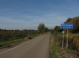
Wordragen
Hamlet in Gelderland, Netherlands
Distance: Approx. 2600 meters
Latitude and longitude: 51.75737,5.22674
Wordragen is a Dutch hamlet, north of Ammerzoden in the Maasdriel municipality of Gelderland province. It was first mentioned in the 13th century as Vurdragen. The etymology is unknown, however it contains woerd (terp, an artificial living mound).

Bokhoven
Distance: Approx. 2526 meters
Latitude and longitude: 51.73333333,5.23333333
Bokhoven is a village in the Netherlands, in the municipality of 's-Hertogenbosch. It is located about seven kilometres northwest of the city center, on the south bank of the river Maas.

Velddriel
Village in Gelderland, Netherlands
Distance: Approx. 3862 meters
Latitude and longitude: 51.7691,5.3058
Velddriel is a village in the Dutch province of Gelderland. The village is a part of the municipality of Maasdriel, and lies about 8 km north of 's-Hertogenbosch. It was first mentioned in 996 as Thrile.

Hedel
Town in Gelderland, Netherlands
Distance: Approx. 209 meters
Latitude and longitude: 51.74666667,5.25916667
Hedel (Dutch pronunciation: [ˈɦeːdəl]) is a town in the Dutch province of Gelderland. It is a part of the municipality of Maasdriel, and lies about 7 km northwest of 's-Hertogenbosch. Hedel was a separate municipality until 1999, when it was merged with Maasdriel.

Dieze
River in the Netherlands
Distance: Approx. 1595 meters
Latitude and longitude: 51.73416667,5.25527778
The Dieze is a short river in North Brabant, the Netherlands, tributary of the Meuse (Maas). It is formed by the confluence of the rivers Aa and Dommel in 's-Hertogenbosch. The part of the Dieze in the centre of 's-Hertogenbosch is called Binnendieze, a partly covered network of canals.

Californië, Gelderland
Hamlet in Gelderland, Netherlands
Distance: Approx. 1586 meters
Latitude and longitude: 51.74888889,5.23833333
Californië (Dutch for California) is a hamlet in the Dutch province of Gelderland. It is located in the municipality of Maasdriel, between the villages Ammerzoden and Hedel. It was first mentioned in 1867 as Californië, and is a reference to an inn which existed after 1852.

Empel en Meerwijk
Former municipality in North Brabant, Netherlands
Distance: Approx. 3316 meters
Latitude and longitude: 51.73555556,5.305
Empel en Meerwijk is a former municipality of the Dutch province of North Brabant.

Engelen
Place in North Brabant, Netherlands
Distance: Approx. 3508 meters
Latitude and longitude: 51.71666667,5.26666667
Engelen is a village in the Dutch province of North Brabant. It is part of the municipality of 's-Hertogenbosch.
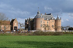
Ammersoyen Castle
Castle in Gelderland, Netherlands
Distance: Approx. 2233 meters
Latitude and longitude: 51.7515,5.2294
Ammersoyen Castle (Dutch: Kasteel Ammersoyen) is located in Ammerzoden in the Bommelerwaard region in the province of Gelderland, the Netherlands. When the original construction of the castle occurred is unclear; some sources claim it was as early as the 12th century. However, the consensus among historians is that the Van Herlaer family completed the castle in the 1350s.
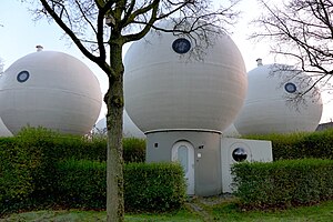
Bolwoningen
Dutch community in Den Bosch, Netherlands, consisting of 50 spherical houses
Distance: Approx. 3728 meters
Latitude and longitude: 51.7297,5.3066
Bolwoningen are Dutch spherical houses in the Maaspoort neighborhood of 's-Hertogenbosch, Netherlands. It consists of 50 spherical houses grouped together near to a canal.

Bokhoven Castle
Distance: Approx. 2277 meters
Latitude and longitude: 51.736915,5.233537
Bokhoven Castle was a big defendable castle in Bokhoven, the Netherlands. A moat and part of the northern wall of the outer bailey are all that reminds of the castle.
Weather in this IP's area
moderate rain
3 Celsius
-1 Celsius
2 Celsius
3 Celsius
1029 hPa
84 %
1029 hPa
1028 hPa
10000 meters
4.21 m/s
9.04 m/s
60 degree
100 %