Country:
 Romania
Region:
City:
Latitude and Longitude:
Time Zone:
Postal Code:
IP information under different IP Channel
ip-api
Country
Region
City
ASN
Time Zone
ISP
Blacklist
Proxy
Latitude
Longitude
Postal
Route
IPinfo
Country
Region
City
ASN
Time Zone
ISP
Blacklist
Proxy
Latitude
Longitude
Postal
Route
MaxMind
Country
Region
City
ASN
Time Zone
ISP
Blacklist
Proxy
Latitude
Longitude
Postal
Route
Luminati
Country
RORegion
tm
City
sacalaz
ASN
Time Zone
Europe/Bucharest
ISP
Orange Romania S.A.
Latitude
Longitude
Postal
db-ip
Country
Region
City
ASN
Time Zone
ISP
Blacklist
Proxy
Latitude
Longitude
Postal
Route
ipdata
Country
Region
City
ASN
Time Zone
ISP
Blacklist
Proxy
Latitude
Longitude
Postal
Route
Popular places and events near this IP address
Freidorf
District of Timișoara in Romania
Distance: Approx. 7017 meters
Latitude and longitude: 45.72833333,21.18111111
Freidorf (German for "free village"; Hungarian: Szabadfalu) was one of the first German settlements in Temes County in the Banat, Kingdom of Hungary. In 1920, it became part of Romania; since 1950 it is a district of the city of Timișoara, located on the southwest outskirts of the city. Freidorf maintains historic architecture, old Banat Swabian houses, and many green spaces.
Apa Mare (Bega)
River in Timiș, Romania
Distance: Approx. 5474 meters
Latitude and longitude: 45.7791,21.0377
The Apa Mare (also Vâna Ciurei or Apa Neagră) is a right tributary of the river Bega Veche in Romania. It discharges into the Bega Veche in Beregsău Mare. Its length is 69 km (43 mi) and its basin size is 734 km2 (283 sq mi).

Săcălaz
Commune in Timiș, Romania
Distance: Approx. 1465 meters
Latitude and longitude: 45.75,21.11666667
Săcălaz (formerly Săcalhaz; ‹See Tfd›German: Sackelhausen; Banat Swabian: Sacklass; Hungarian: Szakálháza) is a commune in Timiș County, Romania. It is composed of three villages: Beregsău Mare, Beregsău Mic and Săcălaz (commune seat).

Sânmihaiu Român
Commune in Timiș, Romania
Distance: Approx. 6475 meters
Latitude and longitude: 45.7,21.08333333
Sânmihaiu Român (Hungarian: Bégaszentmihály or Oláhszentmihály; ‹See Tfd›German: Wallachisch St. Michael) is a commune in Timiș County, Romania. It is composed of three villages: Sânmihaiu German, Sânmihaiu Român (commune seat) and Utvin.
Stadionul Gheorghe Rășcanu
Romanian rugby stadium
Distance: Approx. 6480 meters
Latitude and longitude: 45.75608333,21.18402778
Gheorghe Rășcanu Stadium (Romanian: Stadionul Gheorghe Rășcanu) is a multi-purpose stadium in Timișoara, Romania. It is currently used mostly for rugby matches by the local team, SCM Rugby Timișoara. The stadium is named after Timișoara Saracens' legend Gheorghe Rășcanu who played for Timișoara during its golden era.
Blașcovici
Distance: Approx. 7615 meters
Latitude and longitude: 45.7555579,21.1986243
Blașcovici (deprecated: Colonia Blascovici; Hungarian: Blaskovitstelep; ‹See Tfd›German: Blaskowitsch Kolonie) is a district of Timișoara. At the beginning of the 20th century, Blașcovici was a colony of Mehala. Before that, a wealthy family of Roman Catholic canons, the Blaskovits, lived here.

Circumvalațiunii
District of Timișoara, Romania
Distance: Approx. 7410 meters
Latitude and longitude: 45.7653572,21.195234
Circumvalațiunii is a district of Timișoara. Its name comes from Calea Circumvalațiunii, one of the city's most important roads, which crosses it and is so named because it surrounds the historic center and the former fortress. Circumvalațiunii is one of the most expensive residential areas in Timișoara.
Mehala
District of Timișoara in Romania
Distance: Approx. 7735 meters
Latitude and longitude: 45.76467778,21.19957222
Mehala (Hungarian: Ferencváros; ‹See Tfd›German: Franzstadt; Serbian: Мехала, romanized: Mehala; obsolete: Măhală) is a district of Timișoara. Mehala evolved from a slum-like village (in Turkish mahale means "slum") to a neighborhood of houses, villas and many gardens. It is one of the oldest satellite villages of Timișoara and was built in the higher part of the city, west of Palanca Mare.
Ronaț
District of Timișoara, Romania
Distance: Approx. 5410 meters
Latitude and longitude: 45.7561888,21.1702519
Ronaț (Hungarian: Rónáctelep; ‹See Tfd›German: Ronaz) is a district located on the western outskirts of Timișoara. It is a district where houses and villas predominate, which means a low population density.

Timișoara West railway station
Railway station in Timișoara, Romania
Distance: Approx. 6515 meters
Latitude and longitude: 45.72583333,21.17166667
Timișoara West railway station is a station located in Freidorf district of Timișoara. Crossed by CFR Line 926 (Timișoara–Cruceni), the station is currently transited mainly by freight trains serving the fuel depots in the area; a single passenger train connects Timișoara to Cruceni, a village located 49 km from the city. Traffic on the 49-km-long Timișoara–Cruceni railway began on 31 July 1897.
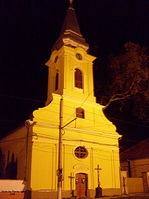
Freidorf Roman Catholic Church
Distance: Approx. 6888 meters
Latitude and longitude: 45.72416667,21.17583333
The St. Roch Church (‹See Tfd›German: Rochuskirche) is a Roman Catholic church in the Freidorf district of Timișoara. The church has 300 believers today, of which 200 are Hungarians, 45 Germans, 40 Romanians, 10 Bulgarians and five Croats (in 1970 there were 2,300 believers, of which 1,800 were Germans).
Ronaț Roman Catholic Church
Distance: Approx. 6546 meters
Latitude and longitude: 45.7536216,21.1847504
The Holy Trinity Church (Romanian: Biserica Sfânta Treime) is a Roman Catholic church in the Ronaț district of Timișoara. It was built in 1928 for the Roman Catholic employees of the Romanian Railways from Ronat, then a colony of Mehala. In fact, Ronaț was built near the railway, close to the station and the company's workplaces.
Weather in this IP's area
broken clouds
12 Celsius
12 Celsius
12 Celsius
13 Celsius
1013 hPa
98 %
1013 hPa
1004 hPa
10000 meters
3.6 m/s
280 degree
75 %
07:39:07
19:08:31