Country:
 Romania
Region:
City:
Latitude and Longitude:
Time Zone:
Postal Code:
IP information under different IP Channel
ip-api
Country
Region
City
ASN
Time Zone
ISP
Blacklist
Proxy
Latitude
Longitude
Postal
Route
IPinfo
Country
Region
City
ASN
Time Zone
ISP
Blacklist
Proxy
Latitude
Longitude
Postal
Route
MaxMind
Country
Region
City
ASN
Time Zone
ISP
Blacklist
Proxy
Latitude
Longitude
Postal
Route
Luminati
Country
RORegion
bv
City
brasov
ASN
Time Zone
Europe/Bucharest
ISP
Orange Romania S.A.
Latitude
Longitude
Postal
db-ip
Country
Region
City
ASN
Time Zone
ISP
Blacklist
Proxy
Latitude
Longitude
Postal
Route
ipdata
Country
Region
City
ASN
Time Zone
ISP
Blacklist
Proxy
Latitude
Longitude
Postal
Route
Popular places and events near this IP address

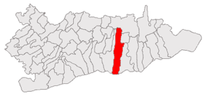
Călărași
Municipality in Romania
Distance: Approx. 2010 meters
Latitude and longitude: 44.2,27.33333333
Călărași (Romanian pronunciation: [kələˈraʃʲ] ), the capital of Călărași County in the Muntenia region, is situated in south-east Romania, on the banks of the Danube's Borcea branch, at about 12 kilometres (7 miles) from the Bulgarian border and 125 kilometres (78 miles) from Bucharest. It is one of six Romanian county seats lying on the Danube river. The city is an industrial centre for lumber and paper, food processing, glass manufacturing, textiles, medical equipment production, and heavy industry, the last one represented by the Călărași steel works.
Silistra Eyalet
Administrative division of the Ottoman Empire from 1593 to 1864
Distance: Approx. 9978 meters
Latitude and longitude: 44.11666667,27.26666667
The Eyalet of Silistra or Silistria (Ottoman Turkish: ایالت سیلیستره; Eyālet-i Silistre), later known as Özü Eyalet (Ottoman Turkish: ایالت اوزی; Eyālet-i Özi) meaning Province of Ochakiv was an eyalet of the Ottoman Empire along the Black Sea littoral and south bank of the Danube River in southeastern Europe. The fortress of Akkerman was under the eyalet's jurisdiction. Its reported area in the 19th century was 71,140 square kilometres (27,469 sq mi).

Modelu
Commune in Călărași, Romania
Distance: Approx. 5998 meters
Latitude and longitude: 44.2,27.38333333
Modelu is a commune in Călărași County, Muntenia, Romania. It is composed of four villages: Modelu, Radu Negru, Stoenești and Tonea. It has a population of 9,835 people.
Cuza Vodă, Călărași
Commune in Călărași, Romania
Distance: Approx. 8641 meters
Latitude and longitude: 44.26666667,27.25
Cuza Vodă is a commune in Călărași County, Muntenia, Romania. It is composed of three villages: Cuza Vodă, Ceacu and Călărașii Vechi. As of 2011 Cuza Vodă had a population of 4,045.

Sud - Muntenia (development region)
Region in Romania
Distance: Approx. 2010 meters
Latitude and longitude: 44.2,27.33333333
Sud - Muntenia (South - Muntenia) is a development region in Romania. As other development regions, it does not have any administrative powers, its main function being to co-ordinate regional development projects and manage funds from the European Union. It is located entirely in the historic region of Muntenia, with its Development Agency HQ in Călărași.
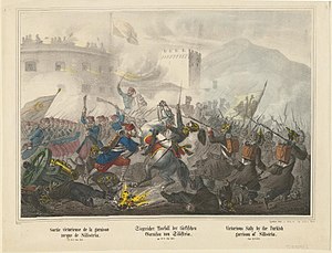
Siege of Silistria
1854 battle of the Crimean War
Distance: Approx. 9868 meters
Latitude and longitude: 44.11916944,27.26136111
The siege of Silistria, or siege of Silistra, took place during the Crimean War, from 11 May to 23 June 1854, when Russian forces besieged the Ottoman fortress of Silistria (present-day Bulgaria). Sustained Ottoman resistance had allowed French and British troops to build up a significant army in nearby Varna. Under additional pressure from Austria, the Russian command, which was about to launch a final assault on the fortress town, was ordered to lift the siege and retreat from the area, thus ending the Danubian phase of the Crimean War.
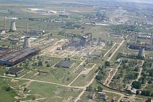
Călărași steel works
Steel mill in Călărași, Romania
Distance: Approx. 3473 meters
Latitude and longitude: 44.232,27.3013
The Călărași steel works (Romanian: Combinatul Siderurgic Călărași), formally Donasid Călărași and formerly Siderca Călărași, is a steel mill in Călărași, Romania.
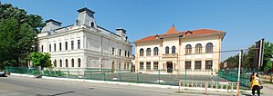
Barbu Știrbei National College
Distance: Approx. 586 meters
Latitude and longitude: 44.206,27.3112
Barbu Știrbei National College (Romanian: Colegiul Național Barbu Știrbei) is a high school located at 159 București Street, Călărași, Romania. In 1864, the sum of 20,000 lei was allocated for the construction of a new school in Călărași. Although, the amount was paid repeatedly, it was used for other purposes until 1881, when the cornerstone was finally laid.

Siege of Silistra (1828)
1829 battle of the Russo-Turkish War (1828–1829)
Distance: Approx. 9958 meters
Latitude and longitude: 44.11861111,27.26028056
The siege of Silistra (July 21 – November 8, 1828) was a siege during the Russo-Turkish War, 1828–1829.
Weather in this IP's area
clear sky
17 Celsius
17 Celsius
17 Celsius
17 Celsius
1010 hPa
95 %
1010 hPa
1009 hPa
10000 meters
2.57 m/s
2.78 m/s
269 degree
10 %
07:13:20
18:44:39