Country:
Region:
City:
Latitude and Longitude:
Time Zone:
Postal Code:
IP information under different IP Channel
ip-api
Country
Region
City
ASN
Time Zone
ISP
Blacklist
Proxy
Latitude
Longitude
Postal
Route
Luminati
Country
Region
bv
City
brasov
ASN
Time Zone
Europe/Bucharest
ISP
Orange Romania S.A.
Latitude
Longitude
Postal
IPinfo
Country
Region
City
ASN
Time Zone
ISP
Blacklist
Proxy
Latitude
Longitude
Postal
Route
db-ip
Country
Region
City
ASN
Time Zone
ISP
Blacklist
Proxy
Latitude
Longitude
Postal
Route
ipdata
Country
Region
City
ASN
Time Zone
ISP
Blacklist
Proxy
Latitude
Longitude
Postal
Route
Popular places and events near this IP address

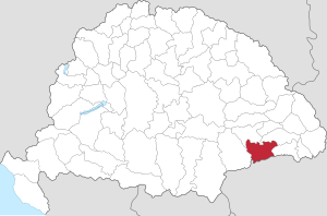
Szeben County
County of the Kingdom of Hungary
Distance: Approx. 397 meters
Latitude and longitude: 45.8,24.15
Szeben was an administrative county (comitatus) of the Kingdom of Hungary. Its territory is now in central Romania (southern Transylvania). The capital of the county was Nagyszeben (present-day Sibiu).

Brukenthal National Museum
Museum in Sibiu, Romania
Distance: Approx. 702 meters
Latitude and longitude: 45.7965,24.15061111
The Brukenthal National Museum (Romanian: Muzeul Național Brukenthal; German: Brukenthalmuseum) is a museum in Sibiu, Transylvania, Romania, established in the late 18th century by Samuel von Brukenthal (1721-1803) in his city palace. Baron Brukenthal, governor of the Grand Principality of Transylvania established his first collections around 1790. The collections were officially opened to the public in 1817, making the museum the oldest institution of its kind on the territory of modern-day Romania.

Sibiu Lutheran Cathedral
Distance: Approx. 548 meters
Latitude and longitude: 45.7978,24.1498
The Lutheran Cathedral of Saint Mary (German: Evangelische Stadtpfarrkirche in Hermannstadt, Romanian: Biserica Evanghelică din Sibiu) is the most famous Gothic-style church in Sibiu (German: Hermannstadt), Transylvania, central Romania. Its massive 73.34 m high steeple is a landmark of the city. The four turrets situated on top of the steeple are said to have been a sign to let foreigners know that the town had the right to sentence to death.
Terezian
Distance: Approx. 507 meters
Latitude and longitude: 45.805,24.141
Terezian is a residential and industrial district located in the northern part of Sibiu, Romania. It is the second oldest district after the city center, and is named after Maria Theresa.

Samuel von Brukenthal National College
School in Sibiu, Sibiu County, Romania
Distance: Approx. 598 meters
Latitude and longitude: 45.7972,24.1497
Samuel von Brukenthal National College (German: Samuel-von-Brukenthal-Gymnasium, Romanian: Colegiul Național "Samuel von Brukenthal", Hungarian: Samuel von Brukenthal Főgimnázium) is a German-language high school founded in Nagyszeben, Transylvania, Kingdom of Hungary, today in Sibiu (German: Hermannstadt), Sibiu County, Romania, located at 5 Albert Huet Square. The school is named after baron Samuel von Brukenthal, governor of the Grand Principality of Transylvania between 6 July 1774 and 9 January 1787. The earliest record of the school is from 1380, making it the oldest German-language school on the territory of present-day Romania.

Jesuit Church, Sibiu
Distance: Approx. 677 meters
Latitude and longitude: 45.7971,24.1512
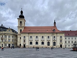
Jesuit Church (Romanian: Biserica Iezuiților), otherwise the Church of the Holy Trinity (Biserica Sfânta Treime), is a Roman Catholic church located at 3 Piața Mare, Sibiu, Romania. Immediately adjacent to Brukenthal Palace, it is one of the most notable baroque churches in Transylvania. The church is listed as a historic monument by Romania's Ministry of Culture and Religious Affairs.

Church between the Fir trees
Distance: Approx. 393 meters
Latitude and longitude: 45.7999086,24.1411418
The Church between the Fir trees (Romanian: Biserica dintre brazi), otherwise the Church of Saints Peter and Paul (Biserica Sfinții Petru și Pavel), is a Romanian Orthodox church located at 17 Reconstrucției Street, Sibiu, Romania. The church is listed as a historic monument by Romania's Ministry of Culture and Religious Affairs. The church was Greek-Catholic prior to 1948, when the nascent communist regime outlawed the church and confiscated its properties.

Lutsch House
Distance: Approx. 785 meters
Latitude and longitude: 45.79677778,24.15275
The Lutsch House (Romanian: Casa Lutsch, German: (Das) Lutschhaus, Hungarian: Lutsch-ház) is a historic monument located in the Grand Square of Sibiu (German: Hermannstadt), Transylvania, Romania. It uses the code name 143469.91 in the National Archaeological Repertory of Romania. The building hosts the headquarters of the Democratic Forum of Germans in Romania (FDGR/DFDR), as well as the headquarters of Democratic Alliance of Hungarians in Romania (UDMR/RMDSZ) in Sibiu.

Bridge of Lies
Bridge in Transylvania, Romania
Distance: Approx. 548 meters
Latitude and longitude: 45.798408,24.150745
The Bridge of Lies (Romanian: Podul Minciunilor, German: Lügenbrücke) is a legendary pedestrian bridge located in the center of the Transylvanian city of Sibiu in central Romania. There are many legends surrounding the bridge because of its name. It is the first cast iron bridge built in Romania.

St. Luke's Church, Sibiu
Heritage site in Sibiu County, Romania
Distance: Approx. 292 meters
Latitude and longitude: 45.804,24.1437
St. Luke's Church (Romanian: Biserica Sfântul Luca) is a Romanian Orthodox church located at 25 Lungă Street, Sibiu, Romania. It is dedicated to Saint Luke.

Second Battle of Nagyszeben
1849 event of the Hungarian Revolution
Distance: Approx. 771 meters
Latitude and longitude: 45.79522222,24.149
The Second Battle of Nagyszeben (or Sibiu, or Hermannstadt) was a battle in the Hungarian war of Independence of 1848-1849 fought on 11 March 1849 between the Hungarian army led by the Polish General Józef Bem and the garrison of Nagyszeben, the Habsburg headquarters of Transylvania, composed by the Russian detachment led by Colonel Grigory Skariatin Austrian troops led by Lieutenant General Alois Pfersmann, and Transylvanian Saxon national guards. Before the battle, Bem managed to make the commander of the Austrian main Commander-in-Chief of Transylvania, Lieutenant General Anton Puchner think that he barricaded himself at Segesvár, while he escaped, heading to Nagyszeben. While Puchner was trying to encircle Segesvár where he thought that Bem was hiding, the latter headed through a quick march to Nagyszeben, where he defeated the Ruso-Austro-Saxon garrison led by General Skariatin, and captured the city.

Piața Mare
Distance: Approx. 744 meters
Latitude and longitude: 45.7966,24.1517
Piața Mare (literally "Grand Square" in Romanian) is the central city square in Sibiu, Romania. It has existed since 1366. In 2005 it was completely renovated.
Weather in this IP's area
broken clouds
2 Celsius
2 Celsius
2 Celsius
2 Celsius
1030 hPa
93 %
1030 hPa
979 hPa
9000 meters
0.51 m/s
75 %
07:20:53
16:54:46