Country:
 Romania
Region:
City:
Latitude and Longitude:
Time Zone:
Postal Code:
IP information under different IP Channel
ip-api
Country
Region
City
ASN
Time Zone
ISP
Blacklist
Proxy
Latitude
Longitude
Postal
Route
IPinfo
Country
Region
City
ASN
Time Zone
ISP
Blacklist
Proxy
Latitude
Longitude
Postal
Route
MaxMind
Country
Region
City
ASN
Time Zone
ISP
Blacklist
Proxy
Latitude
Longitude
Postal
Route
Luminati
Country
RORegion
bv
City
brasov
ASN
Time Zone
Europe/Bucharest
ISP
Orange Romania S.A.
Latitude
Longitude
Postal
db-ip
Country
Region
City
ASN
Time Zone
ISP
Blacklist
Proxy
Latitude
Longitude
Postal
Route
ipdata
Country
Region
City
ASN
Time Zone
ISP
Blacklist
Proxy
Latitude
Longitude
Postal
Route
Popular places and events near this IP address

Gătaia
Town in Timiș, Romania
Distance: Approx. 5114 meters
Latitude and longitude: 45.39166667,21.39694444
Gătaia (Hungarian: Gátalja; ‹See Tfd›German: Gataja, archaically Gotthal; Serbian: Гатаја, romanized: Gataja) is a town in Timiș County, Romania. It administers five villages: Butin, Percosova, Sculia, Șemlacu Mare, and Șemlacu Mic. Declared a town in 2004, it also administered four other villages until that time, when they were split off to form Birda commune.
Fizeș (Bârzava)
River in Caraș-Severin County, Romania
Distance: Approx. 9082 meters
Latitude and longitude: 45.4439,21.5381
The Fizeș (Hungarian: Füzes) is a left tributary of the river Bârzava in Romania. It discharges into the Bârzava near Șoșdea. Its length is 26 km (16 mi) and its basin size is 74 km2 (29 sq mi).

Măureni
Commune in Romania
Distance: Approx. 7122 meters
Latitude and longitude: 45.4,21.5
Măureni (also Morițfeld; ‹See Tfd›German: Moritzfeld; Hungarian: Móricföld) is a commune in Caraș-Severin County, western Romania with a population of 2,579 people. It is composed of two villages, Măureni and Șoșdea (Sósd). At the 2011 census, 97.3% of inhabitants were Romanians, 1.3% Hungarians and 1% Germans.

Birda
Commune in Timiș, Romania
Distance: Approx. 6568 meters
Latitude and longitude: 45.42916667,21.33888889
Birda (Hungarian and German: Birda) is a commune in Timiș County, Romania. It is composed of four villages: Berecuța, Birda (commune seat), Mânăstire and Sângeorge.

Șipet
Village
Distance: Approx. 4170 meters
Latitude and longitude: 45.4,21.4
Șipet is a village in Timiș County, in the Romanian part of Banat. Administratively it is one of the villages included in the commune of Tormac. In 2002 the population of 856 people was ethnically split between Romanians (90%), Slovaks (7%), Magyars (<1%), Germans (<1%) and others (2%).
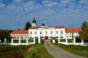
Sveti Đurađ monastery
Distance: Approx. 7244 meters
Latitude and longitude: 45.4111548,21.3358361
Sveti Đurađ or St. George Monastery (Serbian Cyrillic: Манастир Свети Ђурађ; Romanian: Mănăstirea Sfântul Gheorghe) is a medieval Serbian Orthodox monastery located in Mânăstire, Timiș County, Romania, 20 km from the Romanian-Serbian border. It was established in 1485 by Serbian despot Jovan Branković; the present buildings date to 1794, built by Iguman Augustin Petrović as a school and monastic church.
Weather in this IP's area
overcast clouds
12 Celsius
11 Celsius
12 Celsius
12 Celsius
1013 hPa
92 %
1013 hPa
1001 hPa
10000 meters
2.32 m/s
3.5 m/s
317 degree
99 %
07:37:38
19:07:25