Country:
 Romania
Region:
City:
Latitude and Longitude:
Time Zone:
Postal Code:
IP information under different IP Channel
ip-api
Country
Region
City
ASN
Time Zone
ISP
Blacklist
Proxy
Latitude
Longitude
Postal
Route
IPinfo
Country
Region
City
ASN
Time Zone
ISP
Blacklist
Proxy
Latitude
Longitude
Postal
Route
MaxMind
Country
Region
City
ASN
Time Zone
ISP
Blacklist
Proxy
Latitude
Longitude
Postal
Route
Luminati
Country
RORegion
bt
City
botosani
ASN
Time Zone
Europe/Bucharest
ISP
Orange Romania S.A.
Latitude
Longitude
Postal
db-ip
Country
Region
City
ASN
Time Zone
ISP
Blacklist
Proxy
Latitude
Longitude
Postal
Route
ipdata
Country
Region
City
ASN
Time Zone
ISP
Blacklist
Proxy
Latitude
Longitude
Postal
Route
Popular places and events near this IP address
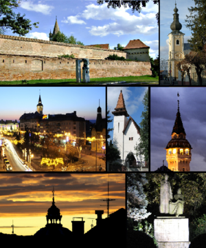
Târgu Mureș
City in Mureș County, Romania
Distance: Approx. 598 meters
Latitude and longitude: 46.54555556,24.5625
Târgu Mureș (, Romanian: [ˈtɨrɡu ˈmureʃ] ; Hungarian: Marosvásárhely [ˈmɒroʃvaːʃaːrhɛj] ; German: Neumarkt am Mieresch) is the seat of Mureș County in the historical region of Transylvania, Romania. It is the 16th-largest city in Romania, with 116,033 inhabitants as of the 2021 census. It lies on the Mureș River, the second-longest river in Romania (after the Danube).

Maros-Torda County
Administrative county (comitatus) of the Kingdom of Hungary
Distance: Approx. 825 meters
Latitude and longitude: 46.55,24.56666667
Maros-Torda was an administrative county (comitatus) of the Kingdom of Hungary. Its territory is now in central Romania (eastern Transylvania) and has been administratively succeeded by county Mureș which consist of about half the territory of the previous Maros-Torda administrative county. Its county seat was Marosvásárhely (present-day Târgu Mureș).

Ascension of the Lord Cathedral, Târgu Mureș
Distance: Approx. 581 meters
Latitude and longitude: 46.54611111,24.56333333
The Ascension of the Lord Cathedral (Romanian: Catedrala Înălţarea Domnului) is a Romanian Orthodox cathedral in Târgu Mureș, Romania. It was built between 1925 and 1934 on the initiative of Archpriest Ștefan Rusu. As the seat of an archpriest and not a bishop, it is a church and not technically a cathedral, but is commonly referred to as such.

Teleki Library
Museum and library in Romania
Distance: Approx. 279 meters
Latitude and longitude: 46.54277778,24.56555556
The Teleki Library (Hungarian: Teleki Téka, Romanian: Biblioteca Teleki-Bolyai), also known as Teleki-Bolyai Library and Bibliotheca Telekiana, is a historic public library and current museum in Târgu-Mureş, Romania. One of the richest Transylvanian collections of cultural artefacts, it was founded by the Hungarian Count Sámuel Teleki in 1802, at the time when Transylvania was part of the Habsburg monarchy, and has been open to the reading public ever since. It was among the first institutions of its kind in the Kingdom of Hungary.

Palace of Culture (Târgu Mureș)
Distance: Approx. 855 meters
Latitude and longitude: 46.54333333,24.55805556
The Palace of Culture (Romanian: Palatul Culturii, Hungarian: Kultúrpalota) is an edifice located in the centre of Târgu Mureș (Marosvásárhely), Romania. The building houses the Mureș County Library, the Mureș County Museum, and the State Philharmonic of Târgu Mureș. The Palace of Culture of Târgu Mureș is listed in the National Register of Historic Monuments.

Petru Maior University of Târgu Mureș
Distance: Approx. 436 meters
Latitude and longitude: 46.54666667,24.56833333
The Petru Maior University (Romanian: Universitatea Petru Maior) of Târgu Mureș, Romania, was a university founded in 1960. In September 2018, Petru Maior University was incorporated into the University of Medicine and Pharmacy of Târgu Mureș.

Saint John the Baptist Church, Târgu Mureș
Heritage site in Mureș County, Romania
Distance: Approx. 523 meters
Latitude and longitude: 46.545844,24.563992
Saint John the Baptist Church (Romanian: Biserica Sfântul Ioan Botezătorul, Hungarian: Keresztelő Szent János Plébánia) is a baroque, Catholic church in the city center of Târgu Mureș, Romania.
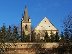
Fortress Church, Târgu Mureș
Distance: Approx. 481 meters
Latitude and longitude: 46.54666667,24.56638889
The Fortress Church or the Big Church (in Hungarian Vártemplom) is the oldest surviving church in Târgu Mureș.

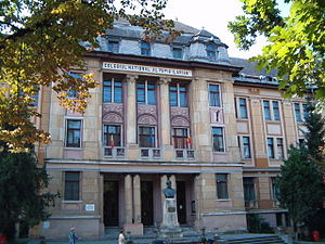
Unirea National College (Târgu Mureș)
High school in Târgu Mureș, Romania
Distance: Approx. 557 meters
Latitude and longitude: 46.54769444,24.57069444
Unirea National College (Romanian: Colegiul Național "Unirea") is a high school located at 15 Mihai Viteazul Street, Târgu Mureș, Romania. The school was founded in 1919, after the Union of Transylvania with Romania, as the successor of the local Girls' Economic School. In 1959 it was named "Unirea" and it was moved to its present-day building, which was originally built in 1903−1905 for a Hungarian Catholic college founded in 1702.

Status Quo Ante Synagogue (Târgu Mureș)
Synagogue in Târgu Mures, Romania
Distance: Approx. 894 meters
Latitude and longitude: 46.5453,24.5581
The Synagogue Status Quo Ante in Târgu Mureș (Romanian: Sinagoga Status Quo din Târgu Mureş), also known as the Great Temple in Târgu Mureş, the Big Temple in Târgu Mureş, or the Great Synagogue in Târgu Mureş, is a Status Quo Ante Jewish congregation and synagogue, located at 24 Aurel Filimon Street, Târgu Mureș, in Mureș county, Transylvania, Romania. Designed by Jakob Gartner in an eclectic architectural style, the synagogue was completed in 1900, during the Austro-Hungarian period. The synagogue was included on the National Register of Historic Monuments in Romania in 2004.

Wooden Church, Târgu Mureș
Orthodox church in Târgu Mureș, Romania
Distance: Approx. 862 meters
Latitude and longitude: 46.55054,24.56969
The Wooden Church is a Romanian Orthodox church located at 13 Mitropolit Andrei Șaguna Street in Târgu Mureș, Romania. It is dedicated to the Archangel Michael.
Alexandru Papiu Ilarian National College
Distance: Approx. 355 meters
Latitude and longitude: 46.54595,24.56844
Alexandru Papiu Ilarian National College (Romanian: Colegiul Național „Alexandru Papiu Ilarian”) is a high school located at 12 Bernády György Square, Târgu Mureș, Romania.
Weather in this IP's area
broken clouds
17 Celsius
16 Celsius
17 Celsius
17 Celsius
1011 hPa
68 %
1011 hPa
970 hPa
10000 meters
2.57 m/s
60 degree
73 %
07:23:04
18:58:04