Country:
 France
Region:
City:
Latitude and Longitude:
Time Zone:
Postal Code:
IP information under different IP Channel
ip-api
Country
Region
City
ASN
Time Zone
ISP
Blacklist
Proxy
Latitude
Longitude
Postal
Route
IPinfo
Country
Region
City
ASN
Time Zone
ISP
Blacklist
Proxy
Latitude
Longitude
Postal
Route
MaxMind
Country
Region
City
ASN
Time Zone
ISP
Blacklist
Proxy
Latitude
Longitude
Postal
Route
Luminati
Country
FRRegion
naq
City
trelissac
ASN
Time Zone
Europe/Paris
ISP
Orange
Latitude
Longitude
Postal
db-ip
Country
Region
City
ASN
Time Zone
ISP
Blacklist
Proxy
Latitude
Longitude
Postal
Route
ipdata
Country
Region
City
ASN
Time Zone
ISP
Blacklist
Proxy
Latitude
Longitude
Postal
Route
Popular places and events near this IP address

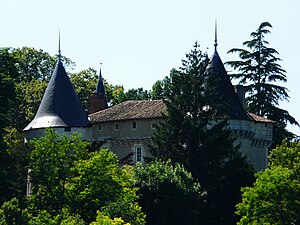
Trélissac
Commune in Nouvelle-Aquitaine, France
Distance: Approx. 527 meters
Latitude and longitude: 45.1967,0.7833
Trélissac (French pronunciation: [tʁelisak]; Occitan: Trelhissac) is a commune in the Dordogne department in Nouvelle-Aquitaine in southwestern France.

Bassillac
Part of Bassillac et Auberoche in Nouvelle-Aquitaine, France
Distance: Approx. 2982 meters
Latitude and longitude: 45.1914,0.8142
Bassillac (French pronunciation: [basijak]; Occitan: Bassilhac, before 2002: Bassilac) is a former commune in the Dordogne department in southwestern France. On 1 January 2017, it was merged into the new commune Bassillac et Auberoche.
Boulazac
Part of Boulazac Isle Manoire in Nouvelle-Aquitaine, France
Distance: Approx. 2675 meters
Latitude and longitude: 45.1719,0.7731
Boulazac (French pronunciation: [bulazak]; Limousin: Bolasac) is a former commune in the Dordogne department in southwestern France. On 1 January 2016, it was merged into the new commune Boulazac Isle Manoire.

Périgueux-Saint-Georges station
Distance: Approx. 3900 meters
Latitude and longitude: 45.17833333,0.73361111
Périgueux-Saint-Georges is a former railway station in Périgueux, Aquitaine, France. The station is located on the Coutras - Tulle railway line. The station was served by TER (local) services between Périgueux and Agen operated by SNCF. It was closed in 2017.

Château du Lieu-Dieu
Distance: Approx. 3683 meters
Latitude and longitude: 45.16277778,0.77388889
Château du Lieu-Dieu is a château in Dordogne, Nouvelle-Aquitaine, France.

Château de Rognac
Distance: Approx. 3498 meters
Latitude and longitude: 45.19861111,0.82111111
The Château de Rognac is a castle converted to a château and mill in the commune of Bassillac, Dordogne, France. The site is privately owned and is not open to the public. It has been listed since 1945 as a monument historique by the French Ministry of Culture.
Château de Trigonant
Distance: Approx. 3419 meters
Latitude and longitude: 45.20805556,0.81666667
The Château de Trigonant is a château in Antonne-et-Trigonant, Dordogne, Nouvelle-Aquitaine, France.

Boulazac Isle Manoire
Commune in Nouvelle-Aquitaine, France
Distance: Approx. 1875 meters
Latitude and longitude: 45.182,0.763
Boulazac Isle Manoire (French pronunciation: [bulazak il manwaʁ]; Limousin: Bolasac Eila Manoire) is a commune in the Dordogne department of southwestern France. The municipality was established on 1 January 2016 and consists of the former communes of Boulazac, Atur and Saint-Laurent-sur-Manoire. On 1 January 2017, the former commune of Sainte-Marie-de-Chignac was merged into Boulazac Isle Manoire.
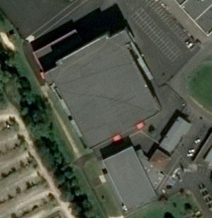
Le Palio (Boulazac)
Distance: Approx. 1833 meters
Latitude and longitude: 45.1838,0.7607
Le Palio, or Salle des sports du Palio, is an indoor sports arena that is located in Boulazac, Périgueux, Dordogne, France. It is used to host sports competitions and concerts. The arena has a seating capacity of 5,200 people for basketball games.

Bassillac et Auberoche
Commune in Nouvelle-Aquitaine, France
Distance: Approx. 2975 meters
Latitude and longitude: 45.191,0.814
Bassillac et Auberoche (French pronunciation: [basijak e obʁɔʃ]; Occitan: Bassilhac e Aubaròcha) is a commune in the department of Dordogne, southwestern France. The municipality was established on 1 January 2017 by merger of the former communes of Bassillac (the seat), Blis-et-Born, Eyliac, Le Change, Milhac-d'Auberoche and Saint-Antoine-d'Auberoche.
Canton of Isle-Manoire
Distance: Approx. 1836 meters
Latitude and longitude: 45.18,0.77
The canton of Isle-Manoire is an administrative division of the Dordogne department, southwestern France. It was created at the French canton reorganisation which came into effect in March 2015. Its seat is in Boulazac Isle Manoire.
Canton of Trélissac
Distance: Approx. 534 meters
Latitude and longitude: 45.2,0.78
The canton of Trélissac is an administrative division of the Dordogne department, southwestern France. It was created at the French canton reorganisation which came into effect in March 2015. Its seat is in Trélissac.
Weather in this IP's area
overcast clouds
7 Celsius
5 Celsius
6 Celsius
9 Celsius
1018 hPa
84 %
1018 hPa
1004 hPa
10000 meters
2.23 m/s
6 m/s
57 degree
96 %
08:00:08
19:30:03