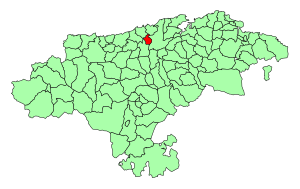
Country:
Region:
City:
Latitude and Longitude:
Time Zone:
Postal Code:
IP information under different IP Channel
ip-api
Country
Region
City
ASN
Time Zone
ISP
Blacklist
Proxy
Latitude
Longitude
Postal
Route
Luminati
Country
Region
cb
City
torrelavega
ASN
Time Zone
Europe/Madrid
ISP
Adamo Telecom Iberia S.A.
Latitude
Longitude
Postal
IPinfo
Country
Region
City
ASN
Time Zone
ISP
Blacklist
Proxy
Latitude
Longitude
Postal
Route
db-ip
Country
Region
City
ASN
Time Zone
ISP
Blacklist
Proxy
Latitude
Longitude
Postal
Route
ipdata
Country
Region
City
ASN
Time Zone
ISP
Blacklist
Proxy
Latitude
Longitude
Postal
Route
Popular places and events near this IP address

Cantabria
Autonomous community and province of Spain
Distance: Approx. 4147 meters
Latitude and longitude: 43.33333333,-4
Cantabria (, also UK: ; Spanish: [kanˈtaβɾja] ) is an autonomous community and province in northern Spain with Santander as its capital city. It is called a comunidad histórica, a historic community, in its current Statute of Autonomy. It is bordered on the east by the Basque autonomous community (province of Biscay), on the south by Castile and León (provinces of León, Palencia and Burgos), on the west by the Principality of Asturias, and on the north by the Cantabrian Sea, which forms part of the Bay of Biscay.
CD Tropezón
Association football club in Spain
Distance: Approx. 2230 meters
Latitude and longitude: 43.330304,-4.047338
Club Deportivo Tropezón is a football team based in Tanos, Torrelavega in the autonomous community of Cantabria. Founded in 1983, it plays in the Tercera Federación – Group 3. Its stadium is Santa Ana with a capacity of 1,500 seats.
Cartes
Municipality in Cantabria, Spain
Distance: Approx. 3300 meters
Latitude and longitude: 43.32555556,-4.06805556
Cartes is a municipality located in the autonomous community of Cantabria, Spain. According to the 2009 census, the city has a population of 5.118 inhabitants.

Cantabria (Congress of Deputies constituency)
Distance: Approx. 4147 meters
Latitude and longitude: 43.33333333,-4
Cantabria—Santander until 1982—is one of the 52 constituencies (Spanish: circunscripciones) represented in the Congress of Deputies, the lower chamber of the Spanish parliament, the Cortes Generales. The constituency currently elects five deputies. Its boundaries correspond to those of the Spanish province of Cantabria.
SD Barreda Balompié
Football club
Distance: Approx. 2708 meters
Latitude and longitude: 43.374201,-4.039392
Sociedad Deportiva Barreda Balompié is a football team based in Barreda, Torrelavega in the autonomous community of Cantabria. Founded in 1917, the team plays in Tercera Federación – Group 3. The club's home ground is Solvay, which has a capacity of 5,100 spectators.
CF Vimenor
Association football club in Spain
Distance: Approx. 6349 meters
Latitude and longitude: 43.356757,-3.96767
Club de Fútbol Vimenor is a football team based in Vioño de Piélagos, Piélagos in the autonomous community of Cantabria. Founded in 1929 as a section of the factory "Vimenor" ("VIdriera MEcánica del NORte"), the team plays in Tercera Federación – Group 3. The club's home ground is La Vidriera, which has a capacity of 1,500 spectators.

Estadio El Malecón
Soccer stadium in Torrelavega, Spain
Distance: Approx. 1481 meters
Latitude and longitude: 43.35055556,-4.06388889
Campos del Malecón, also known as simply El Malecón or Estadio El Malecón, is a stadium in Torrelavega, Spain. It is currently used for football matches and is the home stadium of Gimnástica de Torrelavega. The stadium holds 6,007 spectators and was extensively refurbished in 2011.
Zurita, Cantabria
Locality in Cantabria, Spain
Distance: Approx. 4684 meters
Latitude and longitude: 43.34861111,-3.98777778
Zurita is a village in the municipality of Piélagos in Cantabria, Spain. The elevation of this town is 54 meters (177 feet) above sea level, and it is located 5 kilometers (3.1 miles) from the municipal capital, Renedo de Piélagos; 21 km (13 miles) from the capital of the province, Santander, and 7 km (4.3 miles) from the second largest city in the community, Torrelavega. In 2015 it had a population of 905 inhabitants (INE).
Reocín
Place in Cantabria, Spain
Distance: Approx. 3514 meters
Latitude and longitude: 43.3611,-4.0864
Reocín is a municipality in Cantabria, Spain.

Polanco, Spain
Municipality in Cantabria, Spain
Distance: Approx. 4667 meters
Latitude and longitude: 43.38583333,-4.015
Polanco is a municipality located in the autonomous community of Cantabria, Spain. It has a population of 5,585 inhabitants (2013).

Cantabria (Senate constituency)
Senate constituency in Spain
Distance: Approx. 4147 meters
Latitude and longitude: 43.33333333,-4
Cantabria is one of the 59 constituencies (Spanish: circunscripciones) represented in the Senate of Spain, the upper chamber of the Spanish parliament, the Cortes Generales. The constituency elects four senators. Its boundaries correspond to those of the Spanish province of Cantabria.

Puente San Miguel
Distance: Approx. 3507 meters
Latitude and longitude: 43.35972222,-4.08694444
Puente San Miguel (Spain) (formerly known as Bárcena la Puente), is the capital of the municipality of Reocín in Cantabria, Spain, and its most important population center. It is located 55 kilometers from Santander and is 41 meters (ASL). It is connected to Santander by the Feve company railway.
Weather in this IP's area
clear sky
9 Celsius
7 Celsius
9 Celsius
12 Celsius
1021 hPa
100 %
1021 hPa
1017 hPa
10000 meters
3.06 m/s
4.08 m/s
126 degree
9 %
08:09:57
17:51:57
